Country:
Region:
City:
Latitude and Longitude:
Time Zone:
Postal Code:
IP information under different IP Channel
ip-api
Country
Region
City
ASN
Time Zone
ISP
Blacklist
Proxy
Latitude
Longitude
Postal
Route
Luminati
Country
Region
53
City
poltava
ASN
Time Zone
Europe/Kyiv
ISP
Omega Telecom LLC
Latitude
Longitude
Postal
IPinfo
Country
Region
City
ASN
Time Zone
ISP
Blacklist
Proxy
Latitude
Longitude
Postal
Route
db-ip
Country
Region
City
ASN
Time Zone
ISP
Blacklist
Proxy
Latitude
Longitude
Postal
Route
ipdata
Country
Region
City
ASN
Time Zone
ISP
Blacklist
Proxy
Latitude
Longitude
Postal
Route
Popular places and events near this IP address

Poltava
City and administrative center of Poltava Oblast, Ukraine
Distance: Approx. 53 meters
Latitude and longitude: 49.58944444,34.55138889
Poltava (UK: , US: ; Ukrainian: Полтава, IPA: [polˈtɑwɐ] ) is a city located on the Vorskla River in Central Ukraine. It serves as the administrative center of Poltava Oblast as well as Poltava Raion within the oblast. It also hosts the administration of Poltava urban hromada, one of the hromadas of Ukraine.

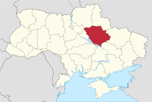
Poltava Oblast
Oblast (region) of Ukraine
Distance: Approx. 53 meters
Latitude and longitude: 49.58944444,34.55138889
Poltava Oblast (Ukrainian: Полтавська область, romanized: Poltavska oblast), also referred to as Poltavshchyna (Ukrainian: Полтавщина), is an oblast (province) of central Ukraine. The administrative center of the oblast is the city of Poltava. Most of its territory was part of the southern regions of the Cossack Hetmanate.

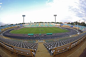
Oleksiy Butovsky Vorskla Stadium
Sports stadium in Poltava, Ukraine
Distance: Approx. 570 meters
Latitude and longitude: 49.59483333,34.54944444
Oleksiy Butovsky Vorskla Stadium is a multi-purpose stadium in Poltava, Ukraine. It is currently used mostly for football matches, and is the home of FC Vorskla Poltava. The stadium holds 24,795 people.

Poltava Governorate
1802–1925 unit of Russia
Distance: Approx. 2138 meters
Latitude and longitude: 49.5744,34.5686
Poltava Governorate was an administrative-territorial unit (guberniya) of the Russian Empire. It included the territory of left-bank Ukraine and was officially created in 1802 from the disbanded Little Russia Governorate, which was split between Chernigov and Poltava Governorates with its capital in Poltava.

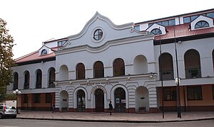
Poltava Art Museum
Distance: Approx. 325 meters
Latitude and longitude: 49.5896,34.5554
Poltava Art Museum is a public art gallery in Poltava, Ukraine which contains many works of native and foreign art and a rich ethnographic collection.

Poltava National Technical University
Public university in Poltava, Ukraine
Distance: Approx. 1922 meters
Latitude and longitude: 49.5761,34.5671
National University "Yuri Kondratyuk Poltava Polytechnic" is a Ukrainian university in Poltava. It is located on Pershotravneva Avenue.

Poltava Raion
Subdivision of Poltava Oblast, Ukraine
Distance: Approx. 53 meters
Latitude and longitude: 49.58944444,34.55138889
Poltava Raion (Ukrainian: Полтавський район) is a raion (district) in Poltava Oblast of central Ukraine. The raion's administrative center is the city of Poltava. Population: 582,391 (2022 estimate).

Poltava University of Economics and Trade
Public university in Poltava, Ukraine
Distance: Approx. 812 meters
Latitude and longitude: 49.595,34.543
Poltava University of Economics and Trade (PUET; Ukrainian: Полтавський університет економіки і торгівлі; ПУЕТ) is one of the biggest universities in Poltava, Ukraine.

Poltava-Kyivska railway station
Railway station in Poltava, Ukraine
Distance: Approx. 2350 meters
Latitude and longitude: 49.60337222,34.52595
Poltava-Kyivska (Ukrainian: Полтава Київська) is a railway station in Poltava, Ukraine.

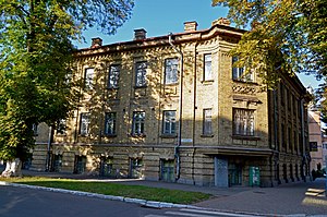
Poltava V.G. Korolenko National Pedagogical University
Higher educational institution in Ukraine
Distance: Approx. 412 meters
Latitude and longitude: 49.59166667,34.55583333
Poltava V.G. Korolenko National Pedagogical University is a higher educational institution in Ukraine that dates back to 1914. The oldest university in Poltava region.
Poltava urban hromada
Urban hromada of Poltava Oblast, Ukraine
Distance: Approx. 53 meters
Latitude and longitude: 49.58944444,34.55138889
Poltava urban territorial hromada (Ukrainian: Полтавська міська територіальна громада, romanized: Poltavska miska terytorialna hromada) is one of the hromadas of Ukraine, located in Poltava Raion, Poltava Oblast. Its administrative centre is the city of Poltava. The hromada has a total area of 550.3 km2 (212.5 sq mi), and a population of 638,519 (as of 2023).

Dynamo Stadium (Poltava)
Stadium in Poltava, Ukraine
Distance: Approx. 344 meters
Latitude and longitude: 49.59069444,34.54633333
Dynamo Stadium (Ukrainian: Стадіон Динамо) is a football stadium in Poltava, Ukraine. Stadium was built in 1938 and opened on 30 July 1938. Stadium was built on the site of police sports ground.
Weather in this IP's area
broken clouds
3 Celsius
1 Celsius
3 Celsius
3 Celsius
1011 hPa
74 %
1011 hPa
992 hPa
10000 meters
2.77 m/s
3.09 m/s
243 degree
76 %
06:58:24
15:55:55