79.171.242.205 - IP Lookup: Free IP Address Lookup, Postal Code Lookup, IP Location Lookup, IP ASN, Public IP
Country:
Region:
City:
Location:
Time Zone:
Postal Code:
ISP:
ASN:
language:
User-Agent:
Proxy IP:
Blacklist:
IP information under different IP Channel
ip-api
Country
Region
City
ASN
Time Zone
ISP
Blacklist
Proxy
Latitude
Longitude
Postal
Route
db-ip
Country
Region
City
ASN
Time Zone
ISP
Blacklist
Proxy
Latitude
Longitude
Postal
Route
IPinfo
Country
Region
City
ASN
Time Zone
ISP
Blacklist
Proxy
Latitude
Longitude
Postal
Route
IP2Location
79.171.242.205Country
Region
al 'asimah
City
jidd hafs
Time Zone
Asia/Bahrain
ISP
Language
User-Agent
Latitude
Longitude
Postal
ipdata
Country
Region
City
ASN
Time Zone
ISP
Blacklist
Proxy
Latitude
Longitude
Postal
Route
Popular places and events near this IP address
Jidhafs
City in Northern Governorate, Bahrain
Distance: Approx. 980 meters
Latitude and longitude: 26.219,50.538
Jidhafs (Arabic: جدحفص, romanized: Jid Ḥafṣ) is a city in Bahrain. It was a municipality of Bahrain in the northern part of the country. Its territory is now in the Capital and Northern Governorate.

Khamis, Bahrain
Village in Northern Governorate, Bahrain
Distance: Approx. 1434 meters
Latitude and longitude: 26.20583333,50.54972222
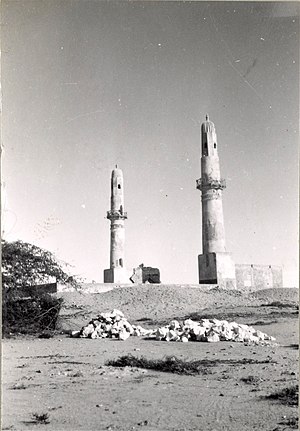
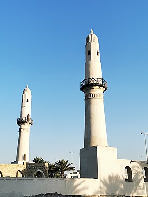
Khamis (Arabic: الخميس) is a village located between Salmaniya and Isa town in the Kingdom of Bahrain. It is largely a residential area with a number of shops and business establishments. It is also the site of the Khamis Mosque, which is the first Islamic mosque in Bahrain.

Khamis Mosque
Mosque in Khamis, Manama, Bahrain
Distance: Approx. 1159 meters
Latitude and longitude: 26.2082,50.5483
The Khamis Mosque (Arabic: مَسْجِدُ ٱلْخَمِيسِ; transliterated: Masǧid al-ḫamīs) is believed to be the first mosque in Bahrain, built during the era of the Umayyad caliph Umar II. According to Al Wasat journalist Kassim Hussain, other sources mention that it was built in a later era during the rule of Uyunids with one minaret. The second was built two centuries later during the rule of Usfurids. The identical twin minarets of this ancient Islamic monument make it easily noticeable as one drives along the Shaikh Salman Road in Khamis.
Bilad Al Qadeem
Town in Capital Governorate, Bahrain
Distance: Approx. 1636 meters
Latitude and longitude: 26.20694444,50.55777778
Bilad al-Qadeem (Arabic: البلاد القديم, The old country) is a suburb of Manama, the capital city of Bahrain. Bilad al-Qadeem used to be a separate town situated next to the village of Zinj until it was incorporated into Manama in the 20th century. The town was the historical and Islamic capital of Bahrain during much of the country's history.
Al Daih
Village in Bahrain
Distance: Approx. 1461 meters
Latitude and longitude: 26.21666667,50.53333333
Al Daih (Arabic: الديه, Persian: دِه/ديه, romanized: deh) is a village on the north of Bahrain. It lies to the east of Budaiya, west of Al Manama.
Tashan, Bahrain
Village in Bahrain
Distance: Approx. 974 meters
Latitude and longitude: 26.21,50.546
Tashan (Arabic:طشان) is a village located in the Kingdom of Bahrain, on the western outskirts of the capital city Manama. It is a village adjacent to Bilad Al Qadeem but significantly smaller.
Sanabis
Village in Manama, Bahrain
Distance: Approx. 1655 meters
Latitude and longitude: 26.23333333,50.55
Sanabis (Arabic: سنابس Sanābis) is a village located in the Kingdom of Bahrain, in the suburbs of the capital city, Manama.

Fakhro Tower
Office building in Manama, Bahrain
Distance: Approx. 1406 meters
Latitude and longitude: 26.23111111,50.54972222
Fakhro Tower is a commercial office complex in Manama, Bahrain, located across the street from the Bahrain City Centre mall. The building is constructed on 30 floors consisting of a double-height lobby with showroom space, five floors of podium parking, and 24 floors of office space. The tower was designed by The Modern Architect and constructed by Kooheji Contractors.
Al Musalla
Village in Northern Governorate, Bahrain
Distance: Approx. 1461 meters
Latitude and longitude: 26.21666667,50.53333333
Al Musalla (Arabic: المصلى) is a village situated in the northern region of the Kingdom of Bahrain, on the western outskirts of the capital city Manama. The villages lies under the Northern Governorate administrative region. The villages lies west of the village of Tashan and Khamis and north of Sehla.

Dana Mall
Shopping mall in Manama, Bahrain
Distance: Approx. 1373 meters
Latitude and longitude: 26.23015,50.55261
Dana Mall is an early shopping mall in the Seef District of Manama, the capital city of Bahrain. The exterior of the mall is in Jordanian stone and the interior includes domes and stained glass ceilings. Dana Mall is one of the first established in Bahrain, opened in 2002.
Al Darah Mosque
Mosque in Bilad Al Qadeem, Manama, Bahrain
Distance: Approx. 1103 meters
Latitude and longitude: 26.20971831,50.5527
The Al Darah Mosque (Arabic: مسجد الدارة) is considered one of the oldest mosques in the Bilad Al Qadeem, Manama, Bahrain. It is located east of the village in an earlier settlement and was founded by Shiite cleric Sheikh Ali Al-Baladi Al-Bahrani, buried in Abu Anbara Cemetery. The inscription marks it as built in 1741.

National Health Regulatory Authority (Bahrain)
Distance: Approx. 1250 meters
Latitude and longitude: 26.22971824,50.54606696
The National Health Regulatory Authority (NHRA) is an independent regulatory body established in 2010, under Law No. 38 of 2009, of the Kingdom of Bahrain.
Weather in this IP's area
clear sky
17 Celsius
17 Celsius
17 Celsius
17 Celsius
1023 hPa
85 %
1023 hPa
1023 hPa
10000 meters
2.83 m/s
3.06 m/s
338 degree
5 %
