Country:
 Czech Republic
Region:
City:
Latitude and Longitude:
Time Zone:
Postal Code:
IP information under different IP Channel
ip-api
Country
Region
City
ASN
Time Zone
ISP
Blacklist
Proxy
Latitude
Longitude
Postal
Route
IPinfo
Country
Region
City
ASN
Time Zone
ISP
Blacklist
Proxy
Latitude
Longitude
Postal
Route
MaxMind
Country
Region
City
ASN
Time Zone
ISP
Blacklist
Proxy
Latitude
Longitude
Postal
Route
Luminati
Country
CZRegion
80
City
opava
ASN
Time Zone
Europe/Prague
ISP
Core4Net, s.r.o.
Latitude
Longitude
Postal
db-ip
Country
Region
City
ASN
Time Zone
ISP
Blacklist
Proxy
Latitude
Longitude
Postal
Route
ipdata
Country
Region
City
ASN
Time Zone
ISP
Blacklist
Proxy
Latitude
Longitude
Postal
Route
Popular places and events near this IP address

Opava
City in the Czech Republic
Distance: Approx. 1538 meters
Latitude and longitude: 49.93805556,17.90444444
Opava (Czech pronunciation: [ˈopava] ; German: Troppau, Polish: Opawa) is a city in the Moravian-Silesian Region of the Czech Republic. It has about 56,000 inhabitants. It lies on the Opava River.
Chlebičov
Municipality in Moravian-Silesian, Czech Republic
Distance: Approx. 3620 meters
Latitude and longitude: 49.95944444,17.9675
Chlebičov (German: Klebsch) is a municipality and village in Opava District in the Moravian-Silesian Region of the Czech Republic. It has about 1,200 inhabitants. It is part of the historic Hlučín Region.

Velké Hoštice
Municipality in Moravian-Silesian, Czech Republic
Distance: Approx. 3992 meters
Latitude and longitude: 49.93611111,17.97388889
Velké Hoštice (German: Groß Hoschütz) is a municipality and village in Opava District in the Moravian-Silesian Region of the Czech Republic. It has about 1,800 inhabitants. It is part of the historic Hlučín Region.
Otice
Municipality in Moravian-Silesian, Czech Republic
Distance: Approx. 4965 meters
Latitude and longitude: 49.91666667,17.87
Otice (Czech pronunciation: [ˈocɪtsɛ]; German: Ottendorf) is a municipality and village in Opava District in the Moravian-Silesian Region of the Czech Republic. It has about 1,500 inhabitants.
Silesian University in Opava
Distance: Approx. 2011 meters
Latitude and longitude: 49.93777778,17.89666667
The Silesian University in Opava, (Czech: Slezská univerzita v Opavě) is a university offering tertiary education. It was established by the law (Nr. 314/199), adopted by the Czech National Council on 9 July 1991, making it one of the youngest universities in the Czech Republic.

Zimní stadion Opava
Distance: Approx. 1266 meters
Latitude and longitude: 49.93759,17.91086833
Zimní stadion Opava is an indoor sporting arena located in Opava, Czech Republic. The capacity of the arena is 5,500 people. The arena was built in 1953 and roofed in 1956 as the third arena in Czechoslovakia.
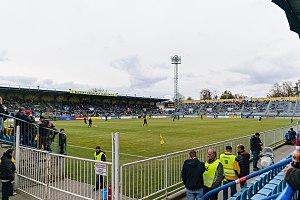
Stadion v Městských sadech
Football stadium in Opava, Czech Republic
Distance: Approx. 2221 meters
Latitude and longitude: 49.949725,17.89009167
Stadion v Městských sadech is a football stadium in Opava, Czech Republic. It is the home stadium of SFC Opava and has a capacity of 7,524 seated places. It is located in the municipal park near the Opava River.

Moravice (river)
River in Moravian-Silesian, Czech Republic
Distance: Approx. 2816 meters
Latitude and longitude: 49.9275,17.94583333
The Moravice (German: Mohra) is a river in the Czech Republic, a right tributary of the Opava River. It flows through the Moravian-Silesian Region. It is 100.5 km (62.4 mi) long, which makes it the 25th longest river in the Czech Republic.

Silesian Museum (Opava)
Distance: Approx. 1394 meters
Latitude and longitude: 49.9374,17.9083
The Silesian Museum (Czech: Slezské zemské muzeum) in Opava is the oldest and the third largest museum in the Czech Republic. The museum also manages other heritage sites.

Institute of Creative Photography
Photography school part of Silesian University (Opava)
Distance: Approx. 2188 meters
Latitude and longitude: 49.93519722,17.89638333
The Institute of Creative Photography (Czech: Institut tvůrčí fotografie, ITF), also referred as Opava School of Photography, is the largest post-secondary school of photography in the Czech Republic. It is part of Silesian University in Opava. It currently has more than 200 students from the Czech Republic, Slovakia, Poland, Germany, Italy, Russia, Ukraine and other countries, in BA, MA, and PhD programmes, taught by nine core teachers (Vladimír Birgus – the Head of the ITF, Pavel Mára, Josef Moucha, Dita Pepe, Václav Podestát, Karel Poneš, Tomáš Pospěch, Jiří Siostrzonek, Jindřich Štreit) and seven external teachers.
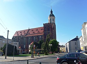
Co-Cathedral of the Assumption of the Virgin Mary, Opava
Church in Opava, Czech Republic
Distance: Approx. 1711 meters
Latitude and longitude: 49.9386,17.9008
The Co-Cathedral of the Assumption of the Virgin Mary (Czech: Konkatedrála Nanebevzetí Panny Marie; also called Our Lady of the Assumption Co-Cathedral or simply Opava Cathedral) is a Gothic church in the historic city centre of Opava in the Czech Republic.
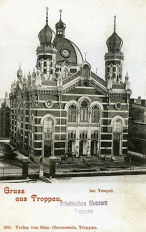
Opava Synagogue
Former synagogue in the Czech Republic
Distance: Approx. 1919 meters
Latitude and longitude: 49.93916667,17.89694444
The Opava Synagogue (Czech: Synagoga v Opavě), or Tempel, was a former Jewish synagogue, located in Opava (German: Troppau), Silesia, in the Czech Republic. Designed by Jakob Gartner in the Romanesque Revival and Moorish Revival styles, the synagogue was completed in 1895. The synagogue was destroyed in 1938, when it was burned and levelled to the ground by the local fanaticized Sudeten Germans.
Weather in this IP's area
overcast clouds
15 Celsius
15 Celsius
14 Celsius
16 Celsius
1016 hPa
92 %
1016 hPa
986 hPa
10000 meters
1.34 m/s
3.58 m/s
32 degree
100 %
06:26:08
19:00:15