Country:
Region:
City:
Latitude and Longitude:
Time Zone:
Postal Code:
IP information under different IP Channel
ip-api
Country
Region
City
ASN
Time Zone
ISP
Blacklist
Proxy
Latitude
Longitude
Postal
Route
Luminati
Country
ASN
Time Zone
Europe/Sofia
ISP
Telecom Group Ltd
Latitude
Longitude
Postal
IPinfo
Country
Region
City
ASN
Time Zone
ISP
Blacklist
Proxy
Latitude
Longitude
Postal
Route
db-ip
Country
Region
City
ASN
Time Zone
ISP
Blacklist
Proxy
Latitude
Longitude
Postal
Route
ipdata
Country
Region
City
ASN
Time Zone
ISP
Blacklist
Proxy
Latitude
Longitude
Postal
Route
Popular places and events near this IP address

Petrich
Place in Blagoevgrad, Bulgaria
Distance: Approx. 431 meters
Latitude and longitude: 41.39527778,23.20694444
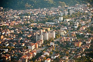
Petrich (Bulgarian: Петрич [ˈpɛtrit͡ʃ]) is a town in Blagoevgrad Province in southwestern Bulgaria, located in Sandanski–Petrich Valley at the foot of the Belasica Mountains in the Strumeshnitsa Valley. According to the 2021 census, the town has 26,778 inhabitants. It is the seat of Petrich Municipality.

Rupite
Village in Blagoevgrad, Bulgaria
Distance: Approx. 6102 meters
Latitude and longitude: 41.44166667,23.24111111
Rupite (Bulgarian: Рупите, pronounced [ˈrupitɛ]) is a village which includes a small mountainous protected area in the southeastern part of Blagoevgrad Province, Bulgaria, 11 kilometers northeast of Petrich, Petrich Municipality, on the western bank of the Struma River. It is best known as the place where alleged Bulgarian clairvoyant Baba Vanga lived. The area is also associated with the crater of an extinct volcano, the hills of Kozhuh and Pchelina, and the warm thermal springs.

Stadion Tsar Samuil
Distance: Approx. 932 meters
Latitude and longitude: 41.38916667,23.19944444
Tsar Samuil Stadium is a multi-purpose stadium in Petrich, Bulgaria. It is currently used mostly for football matches and is the home ground of PFC Belasitsa Petrich. The stadium holds 9,500 spectators.
Belasitsa (village)
Village in Blagoevgrad Province, Bulgaria
Distance: Approx. 6994 meters
Latitude and longitude: 41.36666667,23.13333333
Belasitsa is a village in Petrich Municipality, in Blagoevgrad Province, Bulgaria. As of 2013, it had a population of 1082.
Drangovo, Blagoevgrad Province
Village in Blagoevgrad Province, Bulgaria
Distance: Approx. 6714 meters
Latitude and longitude: 41.41666667,23.28333333
Drangovo is a village in Petrich Municipality, in Blagoevgrad Province, Bulgaria. As of 2013, it had a population of 516.
Kavrakirovo
Village in Blagoevgrad Province, Bulgaria
Distance: Approx. 5839 meters
Latitude and longitude: 41.43333333,23.16666667
Kavrakirovo is a village in Petrich Municipality, in Blagoevgrad Province, Bulgaria. As of 2013, it had a population of 1,545.
Mitino, Blagoevgrad Province
Distance: Approx. 5681 meters
Latitude and longitude: 41.43333333,23.25
Mitino is a village in Petrich Municipality, in Blagoevgrad Province, Bulgaria.
Mihnevo
Village in Blagoevgrad Province, Bulgaria
Distance: Approx. 6498 meters
Latitude and longitude: 41.45,23.2
Mihnevo is a village in Petrich Municipality, in Blagoevgrad Province, Bulgaria.

Parvomay, Blagoevgrad Province
Village in Blagoevgrad Province, Bulgaria
Distance: Approx. 6953 meters
Latitude and longitude: 41.41666667,23.13333333
Parvomay is a village in Petrich Municipality, in Blagoevgrad Province, Bulgaria.
Razhdak
Village in Blagoevgrad Province, Bulgaria
Distance: Approx. 3462 meters
Latitude and longitude: 41.4,23.25
Razhdak is a village in Petrich Municipality, in Blagoevgrad Province, Bulgaria.

Belasitsa Nature Park
Park in Southwest Bulgaria
Distance: Approx. 3121 meters
Latitude and longitude: 41.37011111,23.18672222
Belasitsa Nature Park (Bulgarian: Беласица Природен Парк) covers the northern slopes of Belasitsa Mountain in the Southwest Region of Bulgaria. The total area of the park is 117 km2 (45 sq mi). Belasitsa is part of the European ecological network NATURA 2000 and is managed by the Belasitsa Nature Park Directorate which is a legal entity under the authority of the Executive Forest Agency of Ministry of Agriculture and Food.

Petrich Municipality
Municipality in Blagoevgrad, Bulgaria
Distance: Approx. 3502 meters
Latitude and longitude: 41.4149,23.2388
Petrich Municipality is a municipality in Blagoevgrad Province in Southwestern Bulgaria. It had a population of 47,949 at the 2021 Census.
Weather in this IP's area
scattered clouds
11 Celsius
9 Celsius
11 Celsius
11 Celsius
1029 hPa
35 %
1029 hPa
1001 hPa
10000 meters
1.35 m/s
1.42 m/s
341 degree
28 %
07:07:24
17:14:30
