79.121.75.70 - IP Lookup: Free IP Address Lookup, Postal Code Lookup, IP Location Lookup, IP ASN, Public IP
Country:
 Hungary
Region:
City:
Location:
Time Zone:
Postal Code:
ISP:
ASN:
language:
User-Agent:
Proxy IP:
Blacklist:
IP information under different IP Channel
ip-api
Country
Region
City
ASN
Time Zone
ISP
Blacklist
Proxy
Latitude
Longitude
Postal
Route
db-ip
Country
Region
City
ASN
Time Zone
ISP
Blacklist
Proxy
Latitude
Longitude
Postal
Route
IPinfo
Country
Region
City
ASN
Time Zone
ISP
Blacklist
Proxy
Latitude
Longitude
Postal
Route
IP2Location
79.121.75.70Country
huRegion
hajdu-bihar
City
derecske
Time Zone
Europe/Budapest
ISP
Language
User-Agent
Latitude
Longitude
Postal
ipdata
Country
Region
City
ASN
Time Zone
ISP
Blacklist
Proxy
Latitude
Longitude
Postal
Route
Popular places and events near this IP address

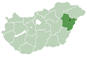
Hajdú–Bihar County
County of Hungary
Distance: Approx. 8964 meters
Latitude and longitude: 47.41666667,21.5
Hajdú–Bihar (Hungarian: Hajdú-Bihar vármegye, pronounced [ˈhɒjduː ˈbihɒr]) is an administrative county (comitatus or vármegye) in eastern Hungary, on the border with Romania. It shares borders with the Hungarian counties Szabolcs-Szatmár-Bereg, Borsod–Abaúj–Zemplén, Jász–Nagykun–Szolnok and Békés. The capital of Hajdú-Bihar county is Debrecen.

Sáránd
Place in Hajdú-Bihar, Hungary
Distance: Approx. 7497 meters
Latitude and longitude: 47.4,21.63333333
Sáránd is a village in Eastern Hungary, in Hajdú-Bihar county, with a small Romanian population. Olympian József Gyönyörű was born here.

Derecske
Town in Hajdú-Bihar, Hungary
Distance: Approx. 562 meters
Latitude and longitude: 47.35369,21.57178
Derecske is a town in Hajdú-Bihar county, in the Northern Great Plain region of eastern Hungary.
Tépe
Place in Hajdú-Bihar, Hungary
Distance: Approx. 3917 meters
Latitude and longitude: 47.31666667,21.58333333
Tépe is a village in Hajdú-Bihar county, in the Northern Great Plain region of eastern Hungary.
Hajdúbagos
Place in Hajdú-Bihar, Hungary
Distance: Approx. 8815 meters
Latitude and longitude: 47.39268,21.66519
Hajdúbagos is a village in Hajdú-Bihar county, in the Northern Great Plain region of eastern Hungary.
Hajdúszovát
Place in Hajdú-Bihar, Hungary
Distance: Approx. 7299 meters
Latitude and longitude: 47.38333333,21.48333333
Hajdúszovát is a village in Hajdú-Bihar county, in the Northern Great Plain region of eastern Hungary.
Konyár
Place in Hajdú-Bihar, Hungary
Distance: Approx. 8405 meters
Latitude and longitude: 47.31666667,21.66666667
Konyár is a village in Hajdú-Bihar county, in the Northern Great Plain region of eastern Hungary.
Weather in this IP's area
overcast clouds
-1 Celsius
-4 Celsius
-1 Celsius
2 Celsius
1026 hPa
93 %
1026 hPa
1014 hPa
7000 meters
2.57 m/s
330 degree
100 %