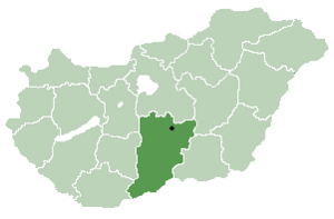
79.121.73.66 - IP Lookup: Free IP Address Lookup, Postal Code Lookup, IP Location Lookup, IP ASN, Public IP
Country:
Region:
City:
Location:
Time Zone:
Postal Code:
ISP:
ASN:
language:
User-Agent:
Proxy IP:
Blacklist:
IP information under different IP Channel
ip-api
Country
Region
City
ASN
Time Zone
ISP
Blacklist
Proxy
Latitude
Longitude
Postal
Route
db-ip
Country
Region
City
ASN
Time Zone
ISP
Blacklist
Proxy
Latitude
Longitude
Postal
Route
IPinfo
Country
Region
City
ASN
Time Zone
ISP
Blacklist
Proxy
Latitude
Longitude
Postal
Route
IP2Location
79.121.73.66Country
Region
csongrad-csanad
City
kistelek
Time Zone
Europe/Budapest
ISP
Language
User-Agent
Latitude
Longitude
Postal
ipdata
Country
Region
City
ASN
Time Zone
ISP
Blacklist
Proxy
Latitude
Longitude
Postal
Route
Popular places and events near this IP address

Pannonian Basin
Large sedimentary basin in Central Europe
Distance: Approx. 3434 meters
Latitude and longitude: 46.5,20
The Pannonian Basin or Carpathian Basin is a large sedimentary basin situated in southeast Central Europe. After the Treaty of Trianon following World War I, the geomorphological term Pannonian Plain became more widely used for roughly the same region, referring to the lowlands in the area occupied by the Pannonian Sea during the Pliocene Epoch. "Pannonian Plain" term being considered not only unhistorical but also topologically erroneous term.

Kömpöc
Place in Bács-Kiskun, Hungary
Distance: Approx. 8691 meters
Latitude and longitude: 46.46666667,19.86666667
Kömpöc is a village in Bács-Kiskun county, in the Southern Great Plain region of southern Hungary. Croats in Hungary call this village Kempac and Kompac.
Kistelek
Town in Csongrád, Hungary
Distance: Approx. 60 meters
Latitude and longitude: 46.473,19.98
Kistelek is a town in Csongrad-Csanád county, in the Southern Great Plain region of southern Hungary.

Pusztaszer
Village in Csongrád, Hungary
Distance: Approx. 8632 meters
Latitude and longitude: 46.55,19.98333333
Pusztaszer is a village in Csongrád county, in the Southern Great Plain region of southern Hungary.
Ópusztaszer
Village in Csongrád, Hungary
Distance: Approx. 8035 meters
Latitude and longitude: 46.48333333,20.08333333
Ópusztaszer (till 1974 Sövényháza) is a village in Csongrád county, in the Southern Great Plain region of southern Hungary. It is most known as the location of the Ópusztaszer National Heritage Park.
Balástya
Village in Csongrád, Hungary
Distance: Approx. 6832 meters
Latitude and longitude: 46.41666667,20.01666667
Balástya is a village in Csongrád County, in the Southern Great Plain region of southern Hungary.
Arrival of the Hungarians
Panoramic painting by Árpád Feszty
Distance: Approx. 9121 meters
Latitude and longitude: 46.48944444,20.09611111
The Arrival of the Hungarians (Hungarian: A magyarok bejövetele; commonly known as Feszty Panorama or Feszty Cyclorama, Hungarian: Feszty-körkép) is a large cyclorama – a circular panoramic painting – by Hungarian painter Árpád Feszty and his assistants, depicting the beginning of the Hungarian conquest of the Carpathian Basin in 895. It was completed in 1894 for the 1000th anniversary of the event. Since the 1100th anniversary of the event in 1995, the painting has been displayed in the Ópusztaszer National Heritage Park, Hungary.
Ópusztaszer National Heritage Park
Memorial park in Ópusztaszer, Hungary
Distance: Approx. 9129 meters
Latitude and longitude: 46.48949167,20.09620278
The Ópusztaszer National Heritage Park is an open-air museum of Hungarian history in Ópusztaszer, Hungary. It was established in 1982 and is most famous for being the location of the Feszty Panorama, a cyclorama by Árpád Feszty and his assistants, depicting the beginning of the Hungarian conquest of the Carpathian Basin in 895. The painting was completed in 1894 for the 1000th anniversary of the event.

Kistelek District
Districts of Hungary in Csongrád
Distance: Approx. 702 meters
Latitude and longitude: 46.4667,19.9833
Kistelek (Hungarian: Kisteleki járás) is a district in western part of Csongrád County. Kistelek is also the name of the town where the district seat is found. The district is located in the Southern Great Plain Statistical Region.
Weather in this IP's area
overcast clouds
1 Celsius
1 Celsius
1 Celsius
1 Celsius
1032 hPa
85 %
1032 hPa
1021 hPa
10000 meters
0.83 m/s
0.9 m/s
1 degree
100 %


