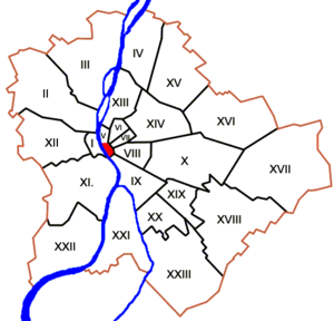
Country:
 Hungary
Region:
City:
Latitude and Longitude:
Time Zone:
Postal Code:
IP information under different IP Channel
ip-api
Country
Region
City
ASN
Time Zone
ISP
Blacklist
Proxy
Latitude
Longitude
Postal
Route
IPinfo
Country
Region
City
ASN
Time Zone
ISP
Blacklist
Proxy
Latitude
Longitude
Postal
Route
MaxMind
Country
Region
City
ASN
Time Zone
ISP
Blacklist
Proxy
Latitude
Longitude
Postal
Route
Luminati
Country
HUASN
Time Zone
Europe/Budapest
ISP
Magyar Telekom plc.
Latitude
Longitude
Postal
db-ip
Country
Region
City
ASN
Time Zone
ISP
Blacklist
Proxy
Latitude
Longitude
Postal
Route
ipdata
Country
Region
City
ASN
Time Zone
ISP
Blacklist
Proxy
Latitude
Longitude
Postal
Route
Popular places and events near this IP address
Inner City (Budapest)
Distance: Approx. 19 meters
Latitude and longitude: 47.498,19.04
Inner City (Hungarian: Belváros; German: Innenstadt) the central part of Budapest. It is more or less equivalent with the historic old town of Pest.

Kingdom of Hungary
Central European monarchy (1000–1946)
Distance: Approx. 207 meters
Latitude and longitude: 47.49611111,19.03944444
The Kingdom of Hungary was a monarchy in Central Europe that existed for nearly a millennium, from the Middle Ages into the 20th century. The Principality of Hungary emerged as a Christian kingdom upon the coronation of the first king Stephen I at Esztergom around the year 1000; his family (the Árpád dynasty) led the monarchy for 300 years. By the 12th century, the kingdom became a European power.

Zero Kilometre Stone
Distance: Approx. 23 meters
Latitude and longitude: 47.49805556,19.04
The Zero Kilometre Stone is a 3 m high limestone sculpture in Budapest that represents Kilometre Zero in Hungary. It consists of a zero sign, with an inscription on its pedestal reading "KM" for kilometres. It was initially located at the threshold of Buda Royal Palace, but was moved to its present location by Széchenyi Chain Bridge when the crossing was completed in 1849.

Buda Castle
Castle complex in Budapest, Hungary
Distance: Approx. 202 meters
Latitude and longitude: 47.49611111,19.03972222
Buda Castle (Hungarian: Budavári Palota, German: Burgpalast), formerly also called the Royal Palace (Hungarian: Királyi-palota) and the Royal Castle (Hungarian: Királyi Vár, German: Königliche Burg), is the historical castle and palace complex of the Hungarian kings in Budapest. First completed in 1265, the Baroque palace that occupies most of the site today was built between 1749 and 1769, severely damaged during the Siege of Budapest in World War II, and rebuilt in a simplified Baroque style during the state communist era. Presently, it houses the Hungarian National Gallery, the Budapest Historical Museum, and the National Széchényi Library.
Bridges of Budapest
Distance: Approx. 145 meters
Latitude and longitude: 47.49666667,19.04083333
The bridges of Budapest, Hungary, crossing the River Danube from north to south are as follows:

Hungarian National Gallery
National art museum in Hungary
Distance: Approx. 189 meters
Latitude and longitude: 47.49622806,19.03977306
The Hungarian National Gallery (also known as Magyar Nemzeti Galéria), was established in 1957 as the national art museum. It is located in Buda Castle in Budapest, Hungary. Its collections cover Hungarian art in all genres, including the works of many nineteenth- and twentieth-century Hungarian artists who worked in Paris and other locations in the West.

Budapest Castle Hill Funicular
Historical funicular railway in Hungary
Distance: Approx. 79 meters
Latitude and longitude: 47.49777778,19.03916667
The Budapest Castle Hill Funicular or Budavári Sikló is a funicular railway in the city of Budapest, in Hungary. It links the Adam Clark Square and the Széchenyi Chain Bridge at river level to Buda Castle above. The line was opened on March 2, 1870, and has been in municipal ownership since 1920.

Kingdom of Hungary (1920–1946)
State in Central Europe between 1920–1946
Distance: Approx. 49 meters
Latitude and longitude: 47.49833333,19.04027778
The Kingdom of Hungary (Hungarian: Magyar Királyság), referred to retrospectively as the Regency and the Horthy era, existed as a country from 1920 to 1946 under the rule of Miklós Horthy, Regent of Hungary, who officially represented the Hungarian monarchy. In reality there was no king, and attempts by King Charles IV to return to the throne shortly before his death were prevented by Horthy. Hungary under Horthy was characterized by its conservative, nationalist, and fiercely anti-communist character.
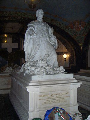
Palatinal Crypt
Habsburg family crypt in the Royal Castle of Buda
Distance: Approx. 185 meters
Latitude and longitude: 47.49628,19.03967
The Palatinal Crypt (Hungarian: Nádori kripta; German: Palatinsgruft) in Buda Castle, Budapest is the burial place of the Hungarian branch of the Habsburg dynasty, founded by Archduke Joseph, Palatine of Hungary. It is the only interior part of Buda Castle which survived the destruction of World War II and was not demolished during the subsequent decades of rebuilding.

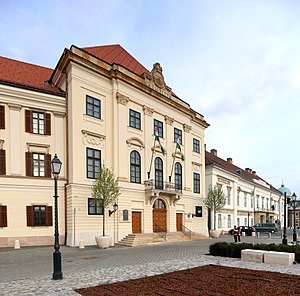
Sándor Palace, Budapest
Building in Budapest, Hungary
Distance: Approx. 181 meters
Latitude and longitude: 47.4978,19.0378
Sándor Palace (Hungarian: Sándor-palota) is a palace in Budapest, Hungary. Located beside the Buda Castle complex in the ancient Castle District, it has served as the official residence and workspace of the president of Hungary since 2003. Sándor Palace is the 37th largest palace in present-day Hungary.
Carmelite Monastery of Buda
Historic theatre in Budapest, Hungary
Distance: Approx. 186 meters
Latitude and longitude: 47.49832778,19.03781111
The Carmelite Monastery of Buda (Hungarian: Karmelita or Karmelita kolostor) is a building in the Castle Quarter of Budapest, the capital city of Hungary, that serves as the seat of the Prime Minister of Hungary. It was formerly a Carmelite Catholic monastery and theatre. The Carmelite Order built the monastery on a parcel that had been occupied by a mosque during the Ottoman occupation of Hungary.

Matthias Fountain
Monument in Budapest, Hungary
Distance: Approx. 210 meters
Latitude and longitude: 47.49617,19.03908
Matthias Fountain (Hungarian: Mátyás kútja, German: König Matthias Brunnen) is a monumental fountain group in the western forecourt of Buda Castle, Budapest. Alajos Stróbl’s Neo-Baroque masterpiece is one of the most frequently photographed landmark in the Hungarian capital. It is sometimes called the ’Trevi Fountain of Budapest’.
Weather in this IP's area
clear sky
26 Celsius
26 Celsius
25 Celsius
26 Celsius
1016 hPa
48 %
1016 hPa
1002 hPa
10000 meters
4.12 m/s
110 degree
06:12:18
19:10:56