Country:
 Hungary
Region:
City:
Latitude and Longitude:
Time Zone:
Postal Code:
IP information under different IP Channel
ip-api
Country
Region
City
ASN
Time Zone
ISP
Blacklist
Proxy
Latitude
Longitude
Postal
Route
IPinfo
Country
Region
City
ASN
Time Zone
ISP
Blacklist
Proxy
Latitude
Longitude
Postal
Route
MaxMind
Country
Region
City
ASN
Time Zone
ISP
Blacklist
Proxy
Latitude
Longitude
Postal
Route
Luminati
Country
HUASN
Time Zone
Europe/Budapest
ISP
Magyar Telekom plc.
Latitude
Longitude
Postal
db-ip
Country
Region
City
ASN
Time Zone
ISP
Blacklist
Proxy
Latitude
Longitude
Postal
Route
ipdata
Country
Region
City
ASN
Time Zone
ISP
Blacklist
Proxy
Latitude
Longitude
Postal
Route
Popular places and events near this IP address

Esztergom County
County of the Kingdom of Hungary
Distance: Approx. 1382 meters
Latitude and longitude: 47.8,18.75
Esztergom County (Latin: comitatus Stringoniensis, Hungarian: Esztergom (vár)megye, Slovak: Ostrihomský komitát / Ostrihomská stolica / Ostrihomská župa, German: Graner Gespanschaft / Komitat Gran) was an administrative county of the Kingdom of Hungary, situated on both sides of the Danube river. Its territory is now divided between Hungary and Slovakia. The territory to the north of the Danube is part of Slovakia, while the territory to the south of the Danube is part of Hungary.

Esztergom
City with county rights in Komárom-Esztergom, Hungary
Distance: Approx. 393 meters
Latitude and longitude: 47.78555556,18.74027778
Esztergom (Hungarian pronunciation: [ˈɛstɛrɡom] ; German: Gran; Latin: Solva or Strigonium; Slovak: Ostrihom, known by alternative names) is a city with county rights in northern Hungary, 46 kilometres (29 miles) northwest of the capital Budapest. It lies in Komárom-Esztergom County, on the right bank of the river Danube, which forms the border with Slovakia there. Esztergom was the capital of Hungary from the 10th until the mid-13th century when King Béla IV of Hungary moved the royal seat to Buda.

Roman Catholic Archdiocese of Esztergom–Budapest
Latin Catholic archdiocese in Hungary
Distance: Approx. 1281 meters
Latitude and longitude: 47.7989,18.7364
The Archdiocese of Esztergom–Budapest (Latin: Archidioecesis Strigoniensis–Budapestinensis) is a Latin Church archdiocese and primatial seat of the Roman Catholic Church in Hungary and the metropolitan see of one of Hungary's four Latin Church ecclesiastical provinces. The archdiocese's archbishop retains the title of "Primate", which gives this see precedence over all other Latin Hungarian dioceses, including the fellow Metropolitan Archbishops of Eger, Kalocsa–Kecskemét and Veszprém, but the incumbent may be individually (and temporarily) outranked if one of them holds a (higher) cardinalate. Its current Archbishop is Péter Erdő.
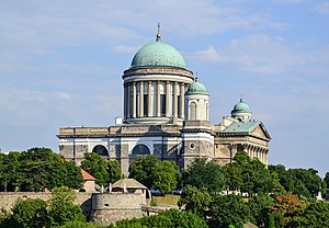
Esztergom Basilica
Ecclesiastic basilica in Esztergom, Hungary
Distance: Approx. 1280 meters
Latitude and longitude: 47.79888889,18.73638889
The Primatial Basilica of the Assumption of the Blessed Virgin Mary and St Adalbert (Hungarian: Nagyboldogasszony és Szent Adalbert prímási főszékesegyház), also known as the Esztergom Basilica (Hungarian: Esztergomi bazilika), is an ecclesiastic basilica in Esztergom, Hungary, the mother church of the Archdiocese of Esztergom-Budapest, and the seat of the Catholic Church in Hungary. It is dedicated to the Assumption of Saint Mary and Saint Adalbert. It is the largest church in Hungary.

Christian Museum, Esztergom
Distance: Approx. 1199 meters
Latitude and longitude: 47.7975,18.73483333
The Christian Museum (Hungarian: Keresztény Múzeum) is the largest ecclesiastical collection in Hungary; it conserves European and Hungarian works of art from the period between the 13th and 19th centuries. The permanent exhibition of the Christian Museum is situated on the second floor of the Primate's Palace in Esztergom-Víziváros, on the bank of the Danube river. The extensive collections of Hungarian, Italian, Dutch, German and Austrian paintings make this museum the third most important picture gallery in Hungary.
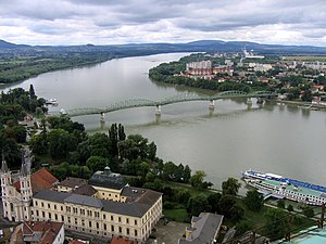
Mária Valéria Bridge
Distance: Approx. 1245 meters
Latitude and longitude: 47.79527778,18.73027778
The Mária Valéria Bridge joins Esztergom in Hungary and Štúrovo in Slovakia, across the River Danube. The bridge is some 500 metres in length. It is named after Archduchess Marie Valerie of Austria (1868–1924), the fourth child of the Emperor of Austria-Hungary, Franz Josef and Elisabeth.

Solva (Hungary)
Early name for what is now Esztergom, Hungary
Distance: Approx. 807 meters
Latitude and longitude: 47.79555556,18.74166667
Solva was an early name for what is now Esztergom, Hungary, in the province of Pannonia, during the Roman period. It was an important part of the limes line along the Danube.

Dark Gate
Distance: Approx. 1311 meters
Latitude and longitude: 47.79955556,18.73777778
The Dark Gate (or alternatively Dark Portal, Hungarian: Sötétkapu) is a tunnel located under the artificial slopes of Castle Hill near St. Adalbert's Basilica in Esztergom, Hungary. The tunnel is 90 metres long and follows the line of the castle's former eastern walls.

Víziváros
Neighborhood of Esztergom, Hungary
Distance: Approx. 1293 meters
Latitude and longitude: 47.79833333,18.73444444
Víziváros (meaning Watertown, Latin: Civitas Archiepiscopalis, German: Wasserstadt) is a neighborhood of Esztergom, Hungary on the right bank of the Danube, under the royal castle and the St. Adalbert Primatial Basilica. The name Watertown derives from the numerous hot springs in the area.

Esztergom District
Districts of Hungary in Komárom-Esztergom
Distance: Approx. 945 meters
Latitude and longitude: 47.7833,18.7333
Esztergom (Hungarian: Esztergomi járás) is a district in north-eastern part of Komárom-Esztergom County. Esztergom is also the name of the town where the district seat is found. The district is located in the Central Transdanubia Statistical Region.

Szenttamás (Esztergom)
Distance: Approx. 924 meters
Latitude and longitude: 47.79666667,18.74222222
Szenttamás (meaning: "Saint Thomas" (for Saint Thomas Becket) is the eastern part of the city of Esztergom in Hungary, on the right bank of the river Danube. It was a separate village until 1895, when it was merged with the "Royal Esztergom" as 2nd district, along with neighboring Víziváros and Szentgyörgymező. It's located on the Szent Tamás Hill.

Esztergom Synagogue
Former synagogue in Esztergom, Hungary
Distance: Approx. 772 meters
Latitude and longitude: 47.79531881,18.74266268
The Esztergom Synagogue is a former Jewish congregation and synagogue, located in the town of Esztergom, Hungary. The synagogue was built in 1859, renovated in 1888, and severely damaged by a bombing during World War II. Since almost all Jewish people in the town were deported during the Holocaust and Communists subsequently gained control of the country, the building has not been used for religious purposes since the 1940s. The synagogue continued to deteriorate until 1962, when the city council bought it from the National Office of the Hungarian Israelites, according to contemporary historian, János Németh.
Weather in this IP's area
clear sky
12 Celsius
10 Celsius
10 Celsius
13 Celsius
1022 hPa
58 %
1022 hPa
1009 hPa
10000 meters
2.39 m/s
2.33 m/s
98 degree
3 %
07:08:33
17:51:22