79.106.28.77 - IP Lookup: Free IP Address Lookup, Postal Code Lookup, IP Location Lookup, IP ASN, Public IP
Country:
 Albania
Region:
City:
Location:
Time Zone:
Postal Code:
ISP:
ASN:
language:
User-Agent:
Proxy IP:
Blacklist:
IP information under different IP Channel
ip-api
Country
Region
City
ASN
Time Zone
ISP
Blacklist
Proxy
Latitude
Longitude
Postal
Route
db-ip
Country
Region
City
ASN
Time Zone
ISP
Blacklist
Proxy
Latitude
Longitude
Postal
Route
IPinfo
Country
Region
City
ASN
Time Zone
ISP
Blacklist
Proxy
Latitude
Longitude
Postal
Route
IP2Location
79.106.28.77Country
alRegion
vlore
City
himare
Time Zone
Europe/Tirane
ISP
Language
User-Agent
Latitude
Longitude
Postal
ipdata
Country
Region
City
ASN
Time Zone
ISP
Blacklist
Proxy
Latitude
Longitude
Postal
Route
Popular places and events near this IP address

Himarë
Municipality in Vlorë, Albania
Distance: Approx. 1927 meters
Latitude and longitude: 40.11666667,19.73333333
Himarë (Albanian definite form: Himara; Greek: Χιμάρα, Chimara or Χειμάρρα, Cheimarra) is a municipality and region in Vlorë County, southern Albania. The municipality has a total area of 571.94 km2 (220.83 sq mi) and consists of the administrative units of Himarë, Horë-Vranisht and Lukovë. It lies between the Ceraunian Mountains and the Albanian Ionian Sea Coast and is part of the Albanian Riviera.

Porto Palermo Castle
Castle near Himarë in southern Albania
Distance: Approx. 5923 meters
Latitude and longitude: 40.062,19.791
Porto Palermo Castle (Albanian: Kalaja e Porto Palermos) is a castle near Himarë in southern Albania. It is situated in the bay of Porto Palermo, a few kilometers south of Himarë along the Albanian Riviera. The area together with Llamani beach will be proclaimed a protected area holding the status of Protected Landscape by the Albanian Government.

Vuno
Village in Vlorë, Albania
Distance: Approx. 6069 meters
Latitude and longitude: 40.13972222,19.69361111
Vuno is a village in the municipality of Himarë, Vlorë County, Albania. It is situated along the road that connects the center of Himarë with the village of Dhërmi on the Albanian Riviera. The population of Vuno is exclusively composed of Orthodox Albanian.

St. Mary's Church, Himarë
Historic site in Himarë
Distance: Approx. 2766 meters
Latitude and longitude: 40.11555556,19.77166667
St. Mary's Church (Albanian: Kisha e Shën Mërisë së Athalit, Greek: Καθολικό Μονής Παναγίας Αθαλιώτισσας) is the katholikon of the monastery of Panagia (Theotokos) Athaliottisa, in Himarë, Vlorë County, Albania. It is a Cultural Monument of Albania.
All Saints' Church, Himarë
Historic site in Himarë
Distance: Approx. 1985 meters
Latitude and longitude: 40.1175,19.73388889
All Saints' Church (Albanian: Kisha e Gjithshenjtorëve, Greek: Ναός Αγιών Πάντων) is a church in Himarë, Vlorë County, Albania. It is a Cultural Monument of Albania.
Pilur
Village in Vlorë, Albania
Distance: Approx. 3953 meters
Latitude and longitude: 40.12861111,19.775
Pilur is a village on the Albanian Riviera in Vlorë County, Albania. It is part of the Himarë municipality.
Kudhës
Village in Vlorë, Albania
Distance: Approx. 6179 meters
Latitude and longitude: 40.09972222,19.81722222
Kudhës is a village on the Albanian Riviera, Vlorë County, Albania. It is part of the Himarë municipality.
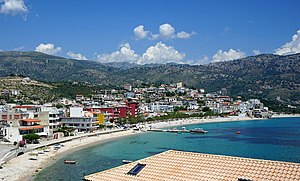
Himarë (town)
Town in Vlorë County, Albania
Distance: Approx. 171 meters
Latitude and longitude: 40.10138889,19.74666667
Himarë (Albanian definite form: Himara, Greek: Χειμάρρα, romanized: Himárra) is a town in Southern Albania along the Albanian Riviera and part of the Vlorë County. It is the largest settlement and the seat of the municipality of Himarë. The town is populated predominantly by an ethnic Greek community.
Qafa e Vishës bus accident
2012 motor vehicle incident in Albania
Distance: Approx. 1931 meters
Latitude and longitude: 40.1167,19.7333
The Qafa e Vishës bus accident occurred on 21 May 2012, at Qafa e Vishës (Albanian pronunciation: [cafa ɛ viʃəs]) near Himarë, Albania, when a bus plunged 80 metres (260 ft) off a cliff. Most of the victims were students of Aleksandër Xhuvani University of Elbasan. The driver is also believed to have been killed.
Petro Ruci Stadium
Multi-use stadium in Orikum, Albania
Distance: Approx. 386 meters
Latitude and longitude: 40.10294444,19.74047222
Petro Ruci Stadium is a multi-use stadium in Orikum, Albania. The stadium has a capacity of 2,000 people and it is mostly used for football matches and it is the home ground of KF Oriku.
Maja 'e Shën Mërtirit
Peninsula in Vlorë, Albania
Distance: Approx. 2394 meters
Latitude and longitude: 40.1,19.71667
Maj 'e Shën Mërtirit is a Peninsula in Albania. It is located in the prefecture of Vlorë County, in the southern part of the country, 140 km south of the country capital, Tirana. The terrain of Maja 'e Shën is hilly in the southeast and mountains in the north.

Bay of Porto Palermo
Bay and a tourist attraction in Southern Albania
Distance: Approx. 5773 meters
Latitude and longitude: 40.06,19.785
The Porto Palermo (Albanian: Gjiri i Panormës or Gjiri i Palermos) is a bay in southwestern Albania. In the middle of the bay there is a small peninsula, it connection to the mainland serves as a parking space for campers and it has sandy beach.
Weather in this IP's area
overcast clouds
10 Celsius
10 Celsius
10 Celsius
10 Celsius
1030 hPa
58 %
1030 hPa
991 hPa
10000 meters
1.35 m/s
2.32 m/s
157 degree
85 %