78.41.136.211 - IP Lookup: Free IP Address Lookup, Postal Code Lookup, IP Location Lookup, IP ASN, Public IP
Country:
Region:
City:
Location:
Time Zone:
Postal Code:
IP information under different IP Channel
ip-api
Country
Region
City
ASN
Time Zone
ISP
Blacklist
Proxy
Latitude
Longitude
Postal
Route
Luminati
Country
Region
eng
City
chesham
ASN
Time Zone
Europe/London
ISP
Unchained ISP Limited
Latitude
Longitude
Postal
IPinfo
Country
Region
City
ASN
Time Zone
ISP
Blacklist
Proxy
Latitude
Longitude
Postal
Route
IP2Location
78.41.136.211Country
Region
england
City
aston clinton
Time Zone
Europe/London
ISP
Language
User-Agent
Latitude
Longitude
Postal
db-ip
Country
Region
City
ASN
Time Zone
ISP
Blacklist
Proxy
Latitude
Longitude
Postal
Route
ipdata
Country
Region
City
ASN
Time Zone
ISP
Blacklist
Proxy
Latitude
Longitude
Postal
Route
Popular places and events near this IP address

Aston Clinton
Human settlement in England
Distance: Approx. 331 meters
Latitude and longitude: 51.799,-0.721
Aston Clinton is a historic village and civil parish in the Vale of Aylesbury in Buckinghamshire, England. The village lies at the foot of the Chiltern Hills, between the Wendover and Aylesbury arms of the Grand Union Canal. Surrounding towns include Wendover to the south, Aylesbury to the west, and Tring to the east - across the nearby county border with Hertfordshire.

RAF Halton
Royal Air Force training base in Buckinghamshire, England
Distance: Approx. 1203 meters
Latitude and longitude: 51.79166667,-0.73611111
Royal Air Force Halton, or more simply RAF Halton, is one of the largest Royal Air Force stations in the United Kingdom. It is located near the village of Halton near Wendover, Buckinghamshire. The site has been in use since the First World War but is due to close by December 2027.

Halton, Buckinghamshire
Human settlement in England
Distance: Approx. 1994 meters
Latitude and longitude: 51.78307,-0.73388
Halton is a small village and civil parish in the Buckinghamshire district of the ceremonial county of Buckinghamshire, England, located about two miles north of Wendover and five miles southeast of Aylesbury.

Buckland, Buckinghamshire
Human settlement in England
Distance: Approx. 909 meters
Latitude and longitude: 51.803,-0.713
Buckland is a village and civil parish in Aylesbury Vale district in Buckinghamshire, England. The village is near the boundary with Hertfordshire, close to Aston Clinton. The hamlet of Buckland Wharf is in the parish.

Drayton Beauchamp
Human settlement in England
Distance: Approx. 2232 meters
Latitude and longitude: 51.801,-0.693
Drayton Beauchamp (pronounced 'Beecham') is a village and civil parish within Aylesbury Vale district in Buckinghamshire, England. It is in the east of the county bordering Hertfordshire, about six miles from Aylesbury and two miles from Tring.

Halton House
Country house in Chiltern Hills, Buckinghamshire, England
Distance: Approx. 2098 meters
Latitude and longitude: 51.78136667,-0.72640556
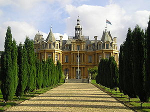
Halton House is a country house in the Chiltern Hills above the village of Halton in Buckinghamshire, England. It was built for Alfred Freiherr de Rothschild between 1880 and 1883. It is used as the main officers' mess for RAF Halton and is listed Grade II* on the National Heritage List for England.

Aston Clinton House
Former mansion in Buckinghamshire, England
Distance: Approx. 791 meters
Latitude and longitude: 51.7943,-0.719
Aston Clinton House (also known as Green Park though referred to as simply Aston Clinton by the Rothschild family) was a large mansion to the south-east of the village of Aston Clinton in Buckinghamshire, England.

Aston Hill Mountain Bike Area
Bike Park in Buckinghamshire
Distance: Approx. 2119 meters
Latitude and longitude: 51.78205,-0.71613
Aston Hill Bike Park is located adjacent to Wendover Woods on the ridge of the Chiltern Hills, above Aston Clinton, Buckinghamshire, England. It is managed by Forestry England and the Community Interest Company (CIC) Chiltern Hills Bike park. Aston Hill is a challenging venue, better suited to intermediate and expert riders when dry and more experienced riders when wet.
St Michael and All Angels Church, Aston Clinton
Distance: Approx. 113 meters
Latitude and longitude: 51.79934,-0.726278
St Michael and All Angels’ Church, Aston Clinton, Buckinghamshire, England. This beautiful 12th-century church lies within the Anglican Diocese of Oxford.
Aston Clinton Hillclimb
Distance: Approx. 1438 meters
Latitude and longitude: 51.789,-0.715
Aston Hill Climb (not "Aston Clinton Hillclimb") was a speed hill climb on public roads up Aston Hill near Aston Clinton in Buckinghamshire which was active from 1904 until 1925. The hill's enduring claim to fame came when Lionel Martin and his partner Robert Bamford achieved success with their self-built 'special' car, and hence named their fledgling car manufacturing business Aston Martin.
Aston Clinton Ragpits
Distance: Approx. 1479 meters
Latitude and longitude: 51.789261,-0.71322
Aston Clinton Ragpits is a 2.9-hectare (7.2-acre) biological Site of Special Scientific Interest in Aston Clinton in Buckinghamshire. It is a former chalk quarry, which is now a nature reserve managed by the Berkshire, Buckinghamshire and Oxfordshire Wildlife Trust. It is in the Chilterns Area of Outstanding Natural Beauty.
Arla Aylesbury
British dairy
Distance: Approx. 1351 meters
Latitude and longitude: 51.812,-0.73
Arla Aylesbury is the largest dairy in the UK; at opening it was the world's biggest dairy, processing over 1.75 billion pints (1 billion litres) of milk per year, around 10% of the milk in the UK. It is owned by Arla Foods UK which is a subsidiary of Arla Foods, a large producer of dairy products in Scandinavia.
Weather in this IP's area
overcast clouds
9 Celsius
9 Celsius
8 Celsius
9 Celsius
1008 hPa
74 %
1008 hPa
992 hPa
10000 meters
0.45 m/s
2.24 m/s
225 degree
89 %
