Country:
 Great Britain
Region:
City:
Latitude and Longitude:
Time Zone:
Postal Code:
IP information under different IP Channel
ip-api
Country
Region
City
ASN
Time Zone
ISP
Blacklist
Proxy
Latitude
Longitude
Postal
Route
IPinfo
Country
Region
City
ASN
Time Zone
ISP
Blacklist
Proxy
Latitude
Longitude
Postal
Route
MaxMind
Country
Region
City
ASN
Time Zone
ISP
Blacklist
Proxy
Latitude
Longitude
Postal
Route
Luminati
Country
GBASN
Time Zone
Europe/London
ISP
CloudCoCo Connect Limited
Latitude
Longitude
Postal
db-ip
Country
Region
City
ASN
Time Zone
ISP
Blacklist
Proxy
Latitude
Longitude
Postal
Route
ipdata
Country
Region
City
ASN
Time Zone
ISP
Blacklist
Proxy
Latitude
Longitude
Postal
Route
Popular places and events near this IP address

Bromley South railway station
National Rail station in London, England
Distance: Approx. 123 meters
Latitude and longitude: 51.4,0.017
Bromley South railway station is on the Chatham Main Line in England, serving the town centre and high street of Bromley, south-east London. It is 10 miles 71 chains (17.5 km) down the line from London Victoria and is situated between Shortlands and Bickley. The station and most trains that serve the station are operated by Southeastern, with some services also operated by Thameslink.

Municipal Borough of Bromley
Distance: Approx. 134 meters
Latitude and longitude: 51.4,0.01666667
Bromley was a local government district in northwest Kent from 1867 to 1965 around the town of Bromley. The area was suburban to London, and formed part of the Metropolitan Police District and from 1933 was included in the area of the London Passenger Transport Board.
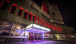
Churchill Theatre
Theatre in Bromley, London, England
Distance: Approx. 370 meters
Latitude and longitude: 51.403611,0.014444
The Churchill Theatre in Bromley, southeast London, was built by the London Borough of Bromley according to designs by the borough architect's department. The Churchill is an example of a repertory theatre built in the style of European opera houses, with a large stage and sub-stage workshops. Integrated into the central library complex overlooking Church House Gardens and Library Gardens, it was built on the side of a hill, disguising the number and size of the lower levels and giving the impression of being smaller by setting the auditorium below ground level which is entered by descending staircases from the foyer.

St. Blaise's Well
Monument in Bromley Palace
Distance: Approx. 370 meters
Latitude and longitude: 51.403,0.022
St Blaise's Well is a holy well located in the grounds of the old Bishop's Palace (residence of Bishops of the see of Rochester until 1845), now part of Bromley Civic Centre in Bromley, London.

The Glades (Bromley)
Shopping mall in Greater London, England
Distance: Approx. 362 meters
Latitude and longitude: 51.4042,0.0168
The Glades is a shopping centre in Bromley, England. It has a total of 135 stores trading from a combined floorspace of 464,000 sq ft (43,100 m2). Opened as The Glades on Tuesday 22 October 1991, the centre is currently jointly owned by Alaska Permanent Fund (85%) and the London Borough of Bromley (15%).
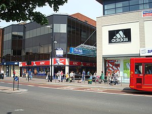
The Mall (Bromley)
Shopping centre in Bromley, England
Distance: Approx. 159 meters
Latitude and longitude: 51.4024,0.0173
The Mall is a shopping centre in Bromley, South East London, England. It is small in size compared to the main shopping centre in Bromley, The Glades.

Bromley Palace
Historic site in Bromley, England
Distance: Approx. 373 meters
Latitude and longitude: 51.4034,0.0215
Bromley Palace (also known as the Bishop's Palace) is a manor house at Bromley in the London Borough of Bromley. It was the bishop's palace of the Bishops of Rochester from the 12th century to 1845. The building, which is now part of Bromley Civic Centre, is a Grade II listed building.
Simpson's Manor
Distance: Approx. 254 meters
Latitude and longitude: 51.4011,0.0141
Simpson's Manor, or Simpson's Place, was a moated medieval manor house in Bromley, Kent, England, with evidence of habitation going back to the reign of Edward I (r. 1272–1307). It was demolished around 1870 but survives in the name of a (minor) local road – Simpson's Place.
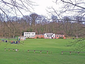
White Hart Field
Cricket ground in London, England
Distance: Approx. 446 meters
Latitude and longitude: 51.405,0.018
White Hart Field was a cricket ground in Bromley in south-east London. The ground, which was in the county of Kent until 1965, was on an area of open space and farm land which stretched from Bromley Palace to Widmore Green. The area was used regularly for cricket in the 18th century and the cricket field was at the back of the White Hart Inn which it was named after, although the only recorded matches on the ground took place in the 1840s.
Gore Court
Distance: Approx. 446 meters
Latitude and longitude: 51.405,0.018
The Grove, Gore Court is a sports ground in Sittingbourne in Kent. It is used for cricket and hockey by Gore Court. The ground is to the west of the centre of Sittingbourne, along the main A2 London road.

St Mark's Church, Bromley
Church in United Kingdom
Distance: Approx. 321 meters
Latitude and longitude: 51.39837,0.01586
St Mark's Church, Bromley is a Church of England parish church in Bromley. It is located on Westmoreland Road, to the south of the town centre.
Stockwell College of Education
Teacher's college in London (1860–1980)
Distance: Approx. 373 meters
Latitude and longitude: 51.4034,0.0215
Stockwell College of Education was a teacher-training college based in South London, England. It was located in Stockwell, South London from 1860 to 1935 and then relocated to the grounds of Bromley Palace, Bromley until its closure in 1980.
Weather in this IP's area
scattered clouds
16 Celsius
16 Celsius
15 Celsius
17 Celsius
1026 hPa
85 %
1026 hPa
1020 hPa
10000 meters
2.57 m/s
40 degree
40 %
06:40:11
19:07:55