Country:
Region:
City:
Latitude and Longitude:
Time Zone:
Postal Code:
IP information under different IP Channel
ip-api
Country
Region
City
ASN
Time Zone
ISP
Blacklist
Proxy
Latitude
Longitude
Postal
Route
Luminati
Country
ASN
Time Zone
Europe/Vienna
ISP
AZISTA GmbH
Latitude
Longitude
Postal
IPinfo
Country
Region
City
ASN
Time Zone
ISP
Blacklist
Proxy
Latitude
Longitude
Postal
Route
db-ip
Country
Region
City
ASN
Time Zone
ISP
Blacklist
Proxy
Latitude
Longitude
Postal
Route
ipdata
Country
Region
City
ASN
Time Zone
ISP
Blacklist
Proxy
Latitude
Longitude
Postal
Route
Popular places and events near this IP address

Liesing
23rd District of Vienna in Austria
Distance: Approx. 583 meters
Latitude and longitude: 48.13777778,16.28444444
Liesing (German pronunciation: [ˈliːzɪŋ] ) is the 23rd district of Vienna. It is on the southwest edge of Vienna, Austria. It was formed after Austria's Anschluss with Germany, when Vienna expanded from 21 districts to 26.

Mauer, Vienna
Distance: Approx. 2184 meters
Latitude and longitude: 48.15055556,16.26888889
Mauer (German for "wall"; Central Bavarian: Maua) is a former village of Lower Austria that has been part of Vienna since 1938. Today's cadastral community belongs to the 23rd District of Vienna, called Liesing. In the west, Mauer borders the Vienna Woods.

Atzgersdorf
Distance: Approx. 891 meters
Latitude and longitude: 48.1461,16.2964
Atzgersdorf (German pronunciation: [ˈat͡sɡɐsˌdɔʁf] ; Central Bavarian: Atzgasduaf) is a former municipality in Lower Austria that is now a part of the 23rd Viennese district Liesing. A small part of the former municipality today is part of the 12th Viennese district Meidling. Today, the cadastral commune Atzgersdorf has an area of 411,42 hectares.
Erlaaer Straße station
Vienna U-Bahn station
Distance: Approx. 1847 meters
Latitude and longitude: 48.1421,16.3165
Erlaaer Straße is a station on U6 of the Vienna U-Bahn. It is located in the Liesing District. It opened on 15 April 1995 as part of the section between Philadelphiabrücke and Siebenhirten.
Perfektastraße station
Vienna U-Bahn station
Distance: Approx. 1585 meters
Latitude and longitude: 48.13666667,16.31333333
Perfektastraße is a station on U6 of the Vienna U-Bahn. It is located in the Liesing District. It opened on 15 April 1995 as part of the section between Philadelphiabrücke and Siebenhirten.

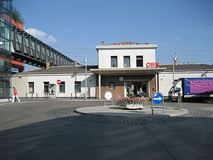
Wien Liesing railway station
Railway station in Vienna, Austria
Distance: Approx. 753 meters
Latitude and longitude: 48.13472222,16.28388889
Wien Liesing is a railway station in the 23 district of Vienna. The station is located 7 km (4.3 mi) southwest of Meidling station and is served by S-Bahn and most ÖBB Regional trains. The station was opened in 1841 along with the Southern Railway.

First Vienna Mountain Spring Pipeline
Distance: Approx. 1382 meters
Latitude and longitude: 48.1383,16.2736
The First Vienna Mountain Spring Pipeline (I. Wiener Hochquellenwasserleitung) is a major part of Vienna's water supply and was the first source of safe drinking water for that city. The 95 km long line was opened on 24 October 1873, after four years of construction. Today, it delivers 62 million cubic meters of water per year (53% of Vienna's total supply in 2007).
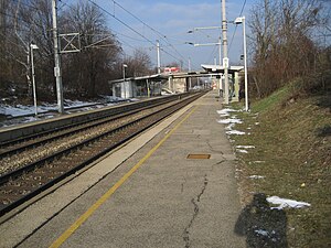
Wien Hetzendorf railway station
Railway station in Vienna, Austria
Distance: Approx. 753 meters
Latitude and longitude: 48.13472222,16.28388889
Wien Hetzendorf is a Vienna S-Bahn station, served by S1 and S2. The station is 1.63 km (1.01 mi) west of Wien Meidling. The station is situated between Altmannsdorfer Straße and Hetzendorfer Straße.

Siebenhirten station
Vienna U-Bahn station
Distance: Approx. 1598 meters
Latitude and longitude: 48.13027778,16.30972222
Siebenhirten (German pronunciation: [ˌziːbm̩ˈhɪʁtn̩] ) is a station on U6 of the Vienna U-Bahn. It is located in the Liesing District. It opened on 15 April 1995 as the southern terminus of the extension of the line from Philadelphiabrücke.

Perchtoldsdorf railway station
Railway station in Lower Austria
Distance: Approx. 1799 meters
Latitude and longitude: 48.12305556,16.28555556
Perchtoldsdorf is a railway station serving the town of Perchtoldsdorf in Lower Austria.

Wien Atzgersdorf railway station
Railway station in Vienna, Austria
Distance: Approx. 966 meters
Latitude and longitude: 48.14694444,16.28861111
Wien Atzgersdorf is a railway station serving Atzgersdorf in the 23rd District of Vienna.

Alterlaa
Residential development in Vienna, Austria
Distance: Approx. 2168 meters
Latitude and longitude: 48.15222222,16.31305556
Alterlaa (Austrian German pronunciation: [altˈɛʁlaː]) is a residential development in Vienna, Austria, designed by Harry Glück. Built from 1975 to 1986, it features distinctive set-backs on its lower floors and large terraces with planting troughs for use by residents. It houses around 9,000 people in 3,200 apartments.
Weather in this IP's area
overcast clouds
5 Celsius
3 Celsius
4 Celsius
7 Celsius
1014 hPa
88 %
1014 hPa
988 hPa
10000 meters
2.35 m/s
7.15 m/s
310 degree
100 %
07:06:36
16:13:49


