Country:
 Italy
ItalyRegion:
City:
Latitude and Longitude:
Time Zone:
Postal Code:
IP information under different IP Channel
ip-api
Country
Region
City
ASN
Time Zone
ISP
Blacklist
Proxy
Latitude
Longitude
Postal
Route
IPinfo
Country
Region
City
ASN
Time Zone
ISP
Blacklist
Proxy
Latitude
Longitude
Postal
Route
MaxMind
Country
Region
City
ASN
Time Zone
ISP
Blacklist
Proxy
Latitude
Longitude
Postal
Route
Luminati
Country
ITRegion
34
City
sernagliadellabattaglia
ASN
Time Zone
Europe/Rome
ISP
ASDASD srl a socio unico
Latitude
Longitude
Postal
db-ip
Country
Region
City
ASN
Time Zone
ISP
Blacklist
Proxy
Latitude
Longitude
Postal
Route
ipdata
Country
Region
City
ASN
Time Zone
ISP
Blacklist
Proxy
Latitude
Longitude
Postal
Route
Popular places and events near this IP address

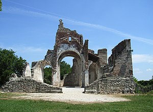
Second Battle of the Piave River
World War I battle won by Italy
Distance: Approx. 7274 meters
Latitude and longitude: 45.83055556,12.20944444
The Second Battle of the Piave River (or Battle of the Solstice), fought between 15 and 23 June 1918, was a decisive victory for the Italian Army against the Austro-Hungarian Empire during World War I, as Italy was part of the Allied Forces, while Austria-Hungary was part of the Central Powers. Though the battle proved to be a decisive blow to the Austro-Hungarian Empire and by extension the Central Powers, its full significance was not initially appreciated in Italy. Yet Erich Ludendorff, on hearing the news, is reported to have said he 'had the sensation of defeat for the first time'.

Crocetta del Montello
Comune in Veneto, Italy
Distance: Approx. 8916 meters
Latitude and longitude: 45.83333333,12.03333333
Crocetta del Montello (or Croseta del Montel in the local Venetian dialect), formerly Crocetta Trevigiana, is a comune (municipality) in the province of Treviso, in the Italian region of Veneto, located about 50 kilometres (31 mi) northwest of Venice and about 25 kilometres (16 mi) northwest of Treviso. As of 31 December 2004, it had a population of 5,807 and an area of 26.4 square kilometres (10.2 sq mi). The town lies about 3 kilometres (2 mi) southwest of the Piave river, and borders the municipalities of Cornuda, Montebelluna, Moriago della Battaglia, Pederobba, Vidor, and Volpago del Montello.
Farra di Soligo
Comune in Veneto, Italy
Distance: Approx. 2026 meters
Latitude and longitude: 45.88333333,12.11666667
Farra di Soligo is a comune (municipality) in the Province of Treviso in the Italian region Veneto, located about 50 kilometres (31 miles) northwest of Venice and about 25 km (16 mi) northwest of Treviso and borders the following municipalities: Follina, Miane, Moriago della Battaglia, Pieve di Soligo, Sernaglia della Battaglia, Valdobbiadene, Vidor.

Follina
Comune in Veneto, Italy
Distance: Approx. 8966 meters
Latitude and longitude: 45.95,12.11666667
Follina is a comune (municipality) in the Province of Treviso in the Italian region Veneto, located about 60 kilometres (37 miles) northwest of Venice and about 35 km (22 mi) northwest of Treviso. It is one of I Borghi più belli d'Italia ("The most beautiful villages of Italy"). Follina is situated in the Treviso countryside, on the "Strada del Prosecco" ("Prosecco wine route"), in the Venetian Prealps.
Nervesa della Battaglia
Comune in Veneto, Italy
Distance: Approx. 7551 meters
Latitude and longitude: 45.83333333,12.21666667
Nervesa della Battaglia is a comune (municipality) in the Province of Treviso in the Italian region Veneto, located about 45 kilometres (28 mi) north of Venice and about 20 kilometres (12 mi) north of Treviso. In February 1358 Nervesa was the scene of a battle in which the Republic of Venice was defeated by the forces of King Louis I of Hungary. That defeat forced the Venetians to sign the highly unfavorable Treaty of Zadar.
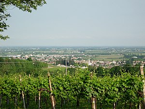
Sernaglia della Battaglia
Comune in Veneto, Italy
Distance: Approx. 521 meters
Latitude and longitude: 45.875,12.13333333
Sernaglia della Battaglia is a comune (municipality) in the Province of Treviso in the Italian region Veneto, located about 50 kilometres (31 miles) northwest of Venice and about 25 kilometres (16 miles) northwest of Treviso. Sernaglia della Battaglia borders the following municipalities: Farra di Soligo, Giavera del Montello, Moriago della Battaglia, Nervesa della Battaglia, Pieve di Soligo, Susegana, Volpago del Montello.
Susegana
Comune in Veneto, Italy
Distance: Approx. 9188 meters
Latitude and longitude: 45.85,12.25
Susegana is a comune (municipality) in the Province of Treviso in the Italian region Veneto, located about 45 km (28 mi) north of Venice and about 20 km (12 mi) north of Treviso.

Montello (hill)
Distance: Approx. 7426 meters
Latitude and longitude: 45.8095361,12.096325
Montello is a hill in the province of Treviso, Veneto, northern Italy, and the site of a World War I battle. The bean-shaped hill measures about 5 km north–south by 13 km east–west. It rises to a maximum of 371 m elevation from the alluvial plain of the Piave River, which runs along the north and west edges of the hill, at about 140 m elevation.
Bavaria, Nervesa della Battaglia
Distance: Approx. 8144 meters
Latitude and longitude: 45.80694444,12.18722222
Bavaria is a ward of the municipality of Nervesa della Battaglia in Treviso province. The village has 1280 residents, is located 78 m asl and its inhabitants are called Bavariani.

Collalto, Susegana
Village in Treviso, Italy
Distance: Approx. 4885 meters
Latitude and longitude: 45.8717,12.1982
Collalto is a village in the province of Treviso in northern Italy, forming a 'frazione' or part of the municipality of Susegana.
Falzè di Piave
Distance: Approx. 3115 meters
Latitude and longitude: 45.861,12.173
Falzè di Piave is a frazione of the municipality of Sernaglia della Battaglia in the Province of Treviso. It is located in the south-east corner of the Piave quarter between the Piave river and its tributary the Soligo.
Soligo (river)
River in Italy
Distance: Approx. 4385 meters
Latitude and longitude: 45.8529,12.1858
The Soligo is a river in the Province of Treviso in Italy. It is supplied by the artificial canal known as the Tajada, flowing out of the lakes of Revine Lago, known as Lago and Santa Maria - the stretch of the canal after the village of Soller is known as the Soligo. It flows west along the Valmareno, before turning south at Follina and finally flowing into the Piave to the south-east of Falzè di Piave.
Weather in this IP's area
few clouds
23 Celsius
22 Celsius
21 Celsius
24 Celsius
1022 hPa
54 %
1022 hPa
1008 hPa
10000 meters
1.38 m/s
2.3 m/s
122 degree
19 %
06:57:26
19:11:31