Country:
 Italy
ItalyRegion:
City:
Latitude and Longitude:
Time Zone:
Postal Code:
IP information under different IP Channel
ip-api
Country
Region
City
ASN
Time Zone
ISP
Blacklist
Proxy
Latitude
Longitude
Postal
Route
IPinfo
Country
Region
City
ASN
Time Zone
ISP
Blacklist
Proxy
Latitude
Longitude
Postal
Route
MaxMind
Country
Region
City
ASN
Time Zone
ISP
Blacklist
Proxy
Latitude
Longitude
Postal
Route
Luminati
Country
ITRegion
45
City
bologna
ASN
Time Zone
Europe/Rome
ISP
ASDASD srl a socio unico
Latitude
Longitude
Postal
db-ip
Country
Region
City
ASN
Time Zone
ISP
Blacklist
Proxy
Latitude
Longitude
Postal
Route
ipdata
Country
Region
City
ASN
Time Zone
ISP
Blacklist
Proxy
Latitude
Longitude
Postal
Route
Popular places and events near this IP address
The Johns Hopkins University SAIS Europe
Italian campus of Johns Hopkins SAIS
Distance: Approx. 1710 meters
Latitude and longitude: 44.49472222,11.35583333
The Johns Hopkins University SAIS Europe in Bologna, Italy, is the European campus of the Paul H. Nitze School of Advanced International Studies (SAIS), a division of Johns Hopkins University located in Washington, D.C. SAIS Europe's degree programs emphasize international economics, international relations, European Union policy, and global risk with options to specialize in a broad range of other policy areas and geographic regions. The Bologna Center, later renamed SAIS Europe in 2013, was founded in 1955 by American academic Charles Grove Haines. In 1961, the school moved to its current location on Via Beniamino Andreatta (formerly named Via Belmeloro), where it was inaugurated by the then university president, Milton S. Eisenhower.

Policlinico Sant'Orsola-Malpighi
Hospital in Emilia-Romagna, Italy
Distance: Approx. 890 meters
Latitude and longitude: 44.49083333,11.36472222
The Sant’Orsola-Malpighi Polyclinic (official Italian name: Azienda ospedaliero-universitaria Policlinico Sant’Orsola Malpighi) is a public research hospital and district general hospital in Bologna. Sant’Orsola-Malpighi Polyclinc is the largest district general hospital in Italy, and the first of the four public hospitals of the city of Bologna (Ospedale Maggiore, Istituto Ortopedico Rizzoli, Ospedale Bellaria). The Polyclinic has approximately 1,535 beds and 5,153 employees (857 doctors).

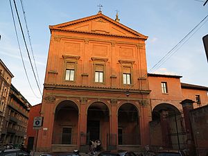
Palazzo Hercolani, Bologna
Palace in Bologna, Italy
Distance: Approx. 1725 meters
Latitude and longitude: 44.49127611,11.35396306
The Palazzo Hercolani or Ercolani is a large Rococo or Neoclassic-style palace in Strada Maggiore in central Bologna, which now serves as the offices for the Political Science Department (Facoltà di Scienze Politiche) of the University of Bologna.
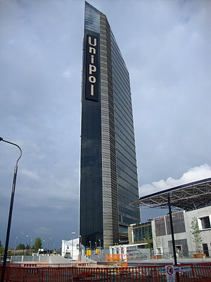
Unipol Tower
Office in Bologna, Italy
Distance: Approx. 1511 meters
Latitude and longitude: 44.495531,11.39103
Unipol Tower is a 33-story skyscraper located at Via Larga in Bologna, Italy. Rising to a height of approximately 127 metres (417 ft), the building serves as the new headquarters of Unipol Bank and includes office and retail space in its 13,000 m2 (140,000 sq ft) square metres of floor area. Construction was completed in 2012.
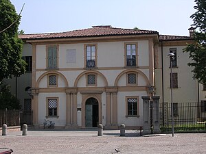
Palazzo Zani, Bologna
Distance: Approx. 946 meters
Latitude and longitude: 44.48888889,11.36334722
Palazzo Zani is a Renaissance palace on via Santo Stefano 56 in central Bologna, region of Emilia Romagna, Italy.
Santa Maria Lacrimosa degli Alemanni
Distance: Approx. 806 meters
Latitude and longitude: 44.487311,11.3651
Santa Maria Lacrimosa degli Alemanni is a small church and sanctuary, built during the Renaissance era, and located on Via Mazzini number 65 in central Bologna, Italy.
Santa Cristina, Bologna
Distance: Approx. 1622 meters
Latitude and longitude: 44.4887,11.3548
Santa Cristina or Santa Cristina della Fondazza is a deconsecrated Roman Catholic church and adjacent former convent, located on Piazzetta Morandi in central Bologna, region of Emilia Romagna, Italy. Since 2007, the barrel-vaulted church has served as a performance hall for concerts, mainly of choir and classical formats, while the convent houses the Department of Visual Arts of the University of Bologna.

San Giuliano, Bologna
Distance: Approx. 1602 meters
Latitude and longitude: 44.485215,11.355411
San Giuliano is a late-Baroque style, Roman Catholic church located on Via Santo Stefano #121 in central Bologna, Italy.

Porta Maggiore, Bologna
Distance: Approx. 1445 meters
Latitude and longitude: 44.49,11.35722222
Porta Maggiore, now known as Porta Mazzini, was the main eastern portal of the former medieval walls of the city of Bologna, Italy. It straddles the site in which the Strada Maggiore of Bologna changes name to via Mazzini, immediately west of the intersection with the Viale di Ciconvallazione. First erected in the 13th century, in 1507, under Pope Julius II a further fortification was added.
Museum of the Risorgimento, Bologna
Distance: Approx. 1414 meters
Latitude and longitude: 44.4882,11.3574
The Civic Museum of the Risorgimento is located in the ground floor of the Casa Carducci, located in Piazza Carducci 5, in central Bologna, Italy.
Bologna San Vitale railway station
Railway station in Italy
Distance: Approx. 925 meters
Latitude and longitude: 44.4962,11.3733
Bologna San Vitale (Italian: Stazione di Bologna San Vitale) is a railway station in Bologna, Italy. The station opened in 2013 and is located on the Bologna–Ancona and Bologna–Florence lines. The train services are operated by Trenitalia Tper.
Bologna Mazzini railway station
Railway station in Italy
Distance: Approx. 596 meters
Latitude and longitude: 44.4827,11.3763
Bologna Mazzini (Italian: Stazione di Bologna Mazzini) is a railway station in Bologna, Italy. The station opened in 2013 and is located on the Bologna–Florence railway. Train services are operated by Trenitalia Tper.
Weather in this IP's area
scattered clouds
21 Celsius
21 Celsius
20 Celsius
23 Celsius
1022 hPa
77 %
1022 hPa
1015 hPa
10000 meters
0.89 m/s
3.13 m/s
281 degree
27 %
07:00:42
19:14:20