Country:
Region:
City:
Latitude and Longitude:
Time Zone:
Postal Code:
IP information under different IP Channel
ip-api
Country
Region
City
ASN
Time Zone
ISP
Blacklist
Proxy
Latitude
Longitude
Postal
Route
Luminati
Country
ASN
Time Zone
Europe/Rome
ISP
ASDASD srl a socio unico
Latitude
Longitude
Postal
IPinfo
Country
Region
City
ASN
Time Zone
ISP
Blacklist
Proxy
Latitude
Longitude
Postal
Route
db-ip
Country
Region
City
ASN
Time Zone
ISP
Blacklist
Proxy
Latitude
Longitude
Postal
Route
ipdata
Country
Region
City
ASN
Time Zone
ISP
Blacklist
Proxy
Latitude
Longitude
Postal
Route
Popular places and events near this IP address
Stadio Virgilio Fedini
Distance: Approx. 1985 meters
Latitude and longitude: 43.57388889,11.52666667
Stadio Virgilio Fedini is a multi-use stadium in San Giovanni Valdarno, Italy. It is currently used mostly for football matches and is the home ground of A.C. Sangiovannese 1927. The stadium holds 3,378.

Montevarchi
Comune in Tuscany, Italy
Distance: Approx. 7625 meters
Latitude and longitude: 43.52861111,11.57
Montevarchi is a town and comune in the province of Arezzo, Tuscany, Italy.

Terranuova Bracciolini
Comune in Tuscany, Italy
Distance: Approx. 7167 meters
Latitude and longitude: 43.55,11.58333333
Terranuova Bracciolini is a comune (municipality) in the Province of Arezzo in the Italian region Tuscany, located about 35 kilometres (22 mi) southeast of Florence and about 25 kilometres (16 mi) northwest of Arezzo. Terranuova Bracciolini borders the following municipalities: Castelfranco Piandiscò, Castiglion Fibocchi, Laterina Pergine Valdarno, Loro Ciuffenna, Montevarchi, San Giovanni Valdarno. Known historically as just Terranuova, the municipality was the birthplace in 1380 of the famed early humanist Poggio Bracciolini, for which it was renamed in 1862.
Valdarno
Valley of the river Arno
Distance: Approx. 2727 meters
Latitude and longitude: 43.56666667,11.53333333
The Valdarno is the valley of the river Arno, from Florence to the sea. The name applies to the entire river basin, though usage of the term generally excludes Casentino and the valleys formed by major tributaries.
Figline Valdarno railway station
Railway station in Tuscany
Distance: Approx. 5554 meters
Latitude and longitude: 43.62166667,11.47333333
The railway station of Figline Valdarno serves the Tuscan town of Figline Valdarno. The station situated on the Florence–Rome railway line, 40 km from Florence, on the stretch between Florence and Arezzo. It is mostly used by commuters coming from Figline Valdarno, Reggello and Pian di Scò going to Florence.
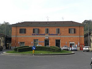
San Giovanni Valdarno railway station
Distance: Approx. 2333 meters
Latitude and longitude: 43.56611111,11.5275
San Giovanni Valdarno railway station (Italian: Stazione di San Giovanni Valdarno) is situated on the Florence–Rome railway line, 50 km from Florence, on the section between Florence and Arezzo. The station is situated near the connection with the "direttissima" (high speed track). One train an hour passes on the direttissima without stopping.
Faella
Frazione in Tuscany, Italy
Distance: Approx. 5663 meters
Latitude and longitude: 43.62621,11.51657
Faella is a frazione of Pian di Scò in the Province of Arezzo in the Italian region Tuscany, located about 30 km southeast of Florence and about 35 km northwest of Arezzo, in the Valdarno. Faella borders the following municipalities: Castelfranco di Sopra, Figline Valdarno, Reggello.
San Filippo Neri, Castelfranco Piandiscò
Distance: Approx. 6458 meters
Latitude and longitude: 43.6209,11.5537
San Filippo Neri is a baroque-style, Roman Catholic church located in the frazione of Castelfranco di Sopra of the town of Castelfranco Piandiscò, in the Valdarno of the region of Tuscany, Italy.
Castelfranco Piandiscò
Comune in Tuscany, Italy
Distance: Approx. 6930 meters
Latitude and longitude: 43.62361111,11.55833333
Castelfranco Piandiscò is a commune in the province of Arezzo, Tuscany, central Italy. It was created on 1 January 2014 from the merger of previous comuni of Castelfranco di Sopra and Pian di Scò. It is located about 30 kilometres (19 mi) southeast of Florence and about 30 kilometres (19 mi) northwest of Arezzo.

Ponte agli Stolli
Frazione in Tuscany, Italy
Distance: Approx. 7808 meters
Latitude and longitude: 43.60111111,11.41166667
Ponte agli Stolli is a hamlet (frazione) in the comune of Figline e Incisa Valdarno in the Metropolitan City of Florence in Tuscany, Italy. As of 2011, it had a population of 177. The hamlet lies to the east of Greve in Chianti and to the west of Figline Valdarno, and, as such, is located on the SP16 Chianti-Valdarno road.

Castelnuovo dei Sabbioni
Frazione in Tuscany, Italy
Distance: Approx. 5656 meters
Latitude and longitude: 43.54083333,11.45222222
Castelnuovo dei Sabbioni is a village (frazione) in the comune of Cavriglia in the province of Arezzo in Tuscany, Italy. As of 2011, it had a population of 1,242. Starting from the mid-sixties, the town was gradually abandoned by the inhabitants due to excavation activity in favor of the nearby Camonti, a newly established hamlet.

San Romolo, Gaville
Distance: Approx. 6065 meters
Latitude and longitude: 43.5869,11.4285
San Romolo is a Romanesque-style, Roman Catholic pieve or parish church located in the frazione of Gaville, within the town limits of Figline Valdarno, region of Tuscany, Italy. This church was originally erected between 1007 and 1070, and was encompassed by walls of a castle of the Ubertini family. The church is dedicated to St Romulus.
Weather in this IP's area
clear sky
9 Celsius
8 Celsius
8 Celsius
10 Celsius
1023 hPa
81 %
1023 hPa
1004 hPa
10000 meters
1.95 m/s
1.91 m/s
53 degree
07:03:03
16:53:11


