Country:
 Italy
ItalyRegion:
City:
Latitude and Longitude:
Time Zone:
Postal Code:
IP information under different IP Channel
ip-api
Country
Region
City
ASN
Time Zone
ISP
Blacklist
Proxy
Latitude
Longitude
Postal
Route
IPinfo
Country
Region
City
ASN
Time Zone
ISP
Blacklist
Proxy
Latitude
Longitude
Postal
Route
MaxMind
Country
Region
City
ASN
Time Zone
ISP
Blacklist
Proxy
Latitude
Longitude
Postal
Route
Luminati
Country
ITASN
Time Zone
Europe/Rome
ISP
ASDASD srl a socio unico
Latitude
Longitude
Postal
db-ip
Country
Region
City
ASN
Time Zone
ISP
Blacklist
Proxy
Latitude
Longitude
Postal
Route
ipdata
Country
Region
City
ASN
Time Zone
ISP
Blacklist
Proxy
Latitude
Longitude
Postal
Route
Popular places and events near this IP address

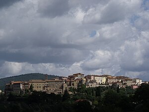
Monte San Savino
Comune in Tuscany, Italy
Distance: Approx. 4848 meters
Latitude and longitude: 43.33333333,11.73333333
Monte San Savino is a town and comune in the province of Arezzo, Tuscany (Italy). It is located on the Essa stream in the Valdichiana. Several of its frazioni occupy higher hills, like Gargonza at 560 metres (1,840 ft) and Palazzuolo, at an elevation of 600 metres (2,000 ft).
Rapolano Terme
Comune in Tuscany, Italy
Distance: Approx. 8729 meters
Latitude and longitude: 43.28333333,11.6
Rapolano Terme is a comune (municipality) in the Province of Siena in the Italian region Tuscany, located about 60 kilometres (37 mi) southeast of Florence and about 20 kilometres (12 mi) east of Siena in the area known as the Crete Senesi. Until 1949 it was known simply as Rapolano. The municipality includes several minor towns, among which the village of Serre di Rapolano.

Rapale, Italy
Frazione in Tuscany, Italy
Distance: Approx. 7923 meters
Latitude and longitude: 43.36666667,11.58333333
Rapale is a village located in south-western Arezzo within the municipality of Bucine in Tuscany, Italy.
San Francesco, Lucignano
Distance: Approx. 9348 meters
Latitude and longitude: 43.274727,11.74646
San Francesco is a Romanesque- and Gothic-style Roman Catholic church located in the center of Lucignano, region of Tuscany, Italy.
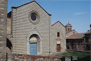
Santissima Annunziata, Lucignano
Distance: Approx. 4268 meters
Latitude and longitude: 43.33122222,11.72544444
The Chiesa della Santissima Annunziata, also once called the Chiesa della Misericordia, is a Renaissance-style Roman Catholic church located in the town of Lucignano, Province of Arezzo, region of Tuscany, Italy. The church was built in 1468 as an oratory for the Company of the Battenti Neri, a fraternity of flagellants. That company was suppressed under the Granduke Leopold in the 1780s, and substituted by the Compagnia di Carità, then by the present Venerabile Arciconfraternita di Misericordia, whose coat of arms is on the portal.

Collegiata di San Michele Arcangelo, Lucignano
Roman Catholic church in Tuscany, Italy
Distance: Approx. 9355 meters
Latitude and longitude: 43.2741845,11.7456716
The Collegiata di San Michele Arcangelo is Renaissance-style Roman Catholic church located on Via San Giuseppe #1, at one end of the Piazza del Tribunale, in the town of Lucignano, Province of Arezzo, region of Tuscany, Italy.

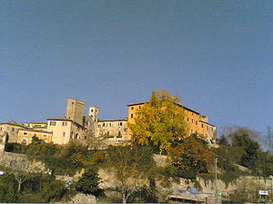
Rigomagno
Frazione in Tuscany, Italy
Distance: Approx. 8869 meters
Latitude and longitude: 43.26222222,11.69666667
Rigomagno is a village in Tuscany, central Italy, administratively a frazione of the comune of Sinalunga, Province of Siena. At the time of the 2001 census its population was 144.
Armaiolo
Frazione in Tuscany, Italy
Distance: Approx. 7582 meters
Latitude and longitude: 43.30388889,11.595
Armaiolo is a village in Tuscany, central Italy, administratively a frazione of the comune of Rapolano Terme, province of Siena. At the time of the 2001 census its population was 79. Armaiolo is about 26 km from Siena and 2 km from Rapolano Terme.
Modanella
Frazione in Tuscany, Italy
Distance: Approx. 7340 meters
Latitude and longitude: 43.27444444,11.6675
Modanella is a village in Tuscany, central Italy, administratively a frazione of the comune of Rapolano Terme, province of Siena. Modanella is about 33 km from Siena and 7 km from Rapolano Terme.

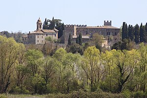
Poggio Santa Cecilia
Frazione in Tuscany, Italy
Distance: Approx. 6088 meters
Latitude and longitude: 43.29305556,11.63611111
Poggio Santa Cecilia is a village in Tuscany, central Italy, administratively a frazione of the comune of Rapolano Terme, province of Siena. Poggio Santa Cecilia is about 30 km from Siena and 4 km from Rapolano Terme.
Weather in this IP's area
clear sky
21 Celsius
20 Celsius
20 Celsius
22 Celsius
1020 hPa
55 %
1020 hPa
965 hPa
10000 meters
1.69 m/s
1.86 m/s
78 degree
2 %
06:59:41
19:12:58