78.24.233.10 - IP Lookup: Free IP Address Lookup, Postal Code Lookup, IP Location Lookup, IP ASN, Public IP
Country:
 Czech Republic
Region:
City:
Location:
Time Zone:
Postal Code:
ISP:
ASN:
language:
User-Agent:
Proxy IP:
Blacklist:
IP information under different IP Channel
ip-api
Country
Region
City
ASN
Time Zone
ISP
Blacklist
Proxy
Latitude
Longitude
Postal
Route
db-ip
Country
Region
City
ASN
Time Zone
ISP
Blacklist
Proxy
Latitude
Longitude
Postal
Route
IPinfo
Country
Region
City
ASN
Time Zone
ISP
Blacklist
Proxy
Latitude
Longitude
Postal
Route
IP2Location
78.24.233.10Country
czRegion
zlinsky kraj
City
uherske hradiste
Time Zone
Europe/Prague
ISP
Language
User-Agent
Latitude
Longitude
Postal
ipdata
Country
Region
City
ASN
Time Zone
ISP
Blacklist
Proxy
Latitude
Longitude
Postal
Route
Popular places and events near this IP address

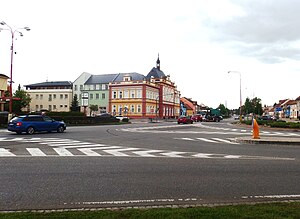
Uherské Hradiště
Town in Zlín Region, Czech Republic
Distance: Approx. 9 meters
Latitude and longitude: 49.06972222,17.45972222
Uherské Hradiště (Czech pronunciation: [ˈuɦɛrskɛː ˈɦraɟɪʃcɛ]; German: Ungarisch Hradisch) is a town in the Zlín Region of the Czech Republic. It has about 25,000 inhabitants. The agglomeration with the two neighbouring towns of Staré Město and Kunovice has over 37,000 inhabitants.
Staré Město (Uherské Hradiště District)
Town in Zlín, Czech Republic
Distance: Approx. 1553 meters
Latitude and longitude: 49.07722222,17.44166667
Staré Město (Czech pronunciation: [ˈstarɛː ˈmɲɛsto]; in 1950–1996 Staré Město u Uherského Hradiště) is a town in Uherské Hradiště District in the Zlín Region of the Czech Republic. It has about 6,600 inhabitants.

Městský fotbalový stadion Miroslava Valenty
Football stadium in Uherské Hradiště
Distance: Approx. 975 meters
Latitude and longitude: 49.06555556,17.47138889
Městský fotbalový stadion Miroslava Valenty is a multi-use stadium in Uherské Hradiště, Czech Republic. It is used mostly for football matches and is the home ground of 1. FC Slovácko.

Kunovice
Town in Zlín, Czech Republic
Distance: Approx. 3139 meters
Latitude and longitude: 49.04194444,17.46638889
Kunovice (Czech pronunciation: [ˈkunovɪtsɛ]; German: Kunowitz) is a town in Uherské Hradiště District in the Zlín Region of the Czech Republic. It has about 5,700 inhabitants.

Kunovice Airport
Airport in Kunovice
Distance: Approx. 4723 meters
Latitude and longitude: 49.02944444,17.43972222
Kunovice Airport (IATA: UHE, ICAO: LKKU) is an airport located about 5 km (3 mi) from Uherské Hradiště, Czech Republic in the town of Kunovice. The airport is home to three aircraft manufacturers: Czech Sport Aircraft, Evektor-Aerotechnik and Let Kunovice. There are currently no scheduled flights operating to the airport.

Huštěnovice
Municipality in Zlín, Czech Republic
Distance: Approx. 4273 meters
Latitude and longitude: 49.10805556,17.46444444
Huštěnovice is a municipality and village in Uherské Hradiště District in the Zlín Region of the Czech Republic. It has about 1,000 inhabitants. Huštěnovice lies approximately 5 kilometres (3 mi) north of Uherské Hradiště, 21 km (13 mi) south-west of Zlín, and 246 km (153 mi) south-east of Prague.

Jalubí
Municipality in Zlín, Czech Republic
Distance: Approx. 5684 meters
Latitude and longitude: 49.11638889,17.42777778
Jalubí is a municipality and village in Uherské Hradiště District in the Zlín Region of the Czech Republic. It has about 1,800 inhabitants. Jalubí lies approximately 6 kilometres (4 mi) north of Uherské Hradiště, 22 km (14 mi) south-west of Zlín, and 243 km (151 mi) south-east of Prague.

Kněžpole
Municipality in Zlín, Czech Republic
Distance: Approx. 5248 meters
Latitude and longitude: 49.09861111,17.51666667
Kněžpole is a municipality and village in Uherské Hradiště District in the Zlín Region of the Czech Republic. It has about 1,100 inhabitants.

Kostelany nad Moravou
Municipality in Zlín, Czech Republic
Distance: Approx. 4718 meters
Latitude and longitude: 49.04527778,17.40694444
Kostelany nad Moravou is a municipality and village in Uherské Hradiště District in the Zlín Region of the Czech Republic. It has about 900 inhabitants. Kostelany nad Moravou lies approximately 5 kilometres (3 mi) south-west of Uherské Hradiště, 29 km (18 mi) south-west of Zlín, and 245 km (152 mi) south-east of Prague.

Popovice (Uherské Hradiště District)
Municipality in Zlín, Czech Republic
Distance: Approx. 5288 meters
Latitude and longitude: 49.0525,17.52722222
Popovice is a municipality and village in Uherské Hradiště District in the Zlín Region of the Czech Republic. It has about 1,000 inhabitants. Popovice lies approximately 6 kilometres (4 mi) east of Uherské Hradiště, 23 km (14 mi) south-west of Zlín, and 253 km (157 mi) south-east of Prague.

Sušice (Uherské Hradiště District)
Municipality in Zlín, Czech Republic
Distance: Approx. 5861 meters
Latitude and longitude: 49.12222222,17.45222222
Sušice is a municipality and village in Uherské Hradiště District in the Zlín Region of the Czech Republic. It has about 700 inhabitants. Sušice lies approximately 7 kilometres (4 mi) north of Uherské Hradiště, 21 km (13 mi) south-west of Zlín, and 244 km (152 mi) south-east of Prague.

Olšava
River in Zlín, Czech Republic
Distance: Approx. 4018 meters
Latitude and longitude: 49.0475,17.41638889
The Olšava is a river in the Czech Republic, a left tributary of the Morava River. It flows through the Zlín Region. It is 44.9 km (27.9 mi) long.
Weather in this IP's area
clear sky
-3 Celsius
-5 Celsius
-3 Celsius
-3 Celsius
1031 hPa
71 %
1031 hPa
998 hPa
10000 meters
1.44 m/s
1.35 m/s
39 degree
6 %