Country:
Region:
City:
Latitude and Longitude:
Time Zone:
Postal Code:
IP information under different IP Channel
ip-api
Country
Region
City
ASN
Time Zone
ISP
Blacklist
Proxy
Latitude
Longitude
Postal
Route
Luminati
Country
Region
14
City
warsaw
ASN
Time Zone
Europe/Warsaw
ISP
Global Connectivity Solutions Llp
Latitude
Longitude
Postal
IPinfo
Country
Region
City
ASN
Time Zone
ISP
Blacklist
Proxy
Latitude
Longitude
Postal
Route
db-ip
Country
Region
City
ASN
Time Zone
ISP
Blacklist
Proxy
Latitude
Longitude
Postal
Route
ipdata
Country
Region
City
ASN
Time Zone
ISP
Blacklist
Proxy
Latitude
Longitude
Postal
Route
Popular places and events near this IP address

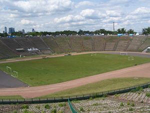
10th-Anniversary Stadium
Stadium in Warsaw
Distance: Approx. 713 meters
Latitude and longitude: 52.23947222,21.04571667
The 10th-Anniversary Stadium (Polish: Stadion Dziesięciolecia), opened in 1955, was for decades the largest stadium in Warsaw, and one of the largest in Poland. Under the Polish People's Republic, it was one of the most advertised construction sites and a principal venue for Party and state festivities. In the 1980s the stadium became dilapidated, as no funds could be found to refurbish it.

Powiśle, Warsaw
Neighborhood in Warsaw, Poland
Distance: Approx. 490 meters
Latitude and longitude: 52.2374,21.0295
Powiśle (Polish pronunciation: [pɔˈviɕlɛ]; literally along-the-Vistula) is a neighbourhood in Warsaw's borough of Śródmieście (Downtown). It is located between the Vistula river and its escarpment. Historically, it is composed of three neighbourhoods: central Powiśle, Mariensztat to the north (just below the Warsaw's Old Town) and Solec to the south.

Tamka Street, Warsaw
Street in Warsaw
Distance: Approx. 699 meters
Latitude and longitude: 52.23722222,21.02611111
Tamka Street, ulica Tamka in Polish, is a street in the Powiśle district of Warsaw, Poland. The street runs downhill from central Warsaw toward the Vistula River and connects ulica Świętokrzyska with the Świętokrzyski Bridge. The street's name originates from a small dam (Polish: tama) that once dammed a stream that formerly flowed along the course of the present street.

Poniatowski Bridge
Bridge in Poland, Poland
Distance: Approx. 613 meters
Latitude and longitude: 52.23611111,21.04166667
The Poniatowski Bridge (Polish: Most Poniatowskiego) is a bridge in Warsaw, Poland. Originally built between 1904 and 1914, it was damaged in each World War and rebuilt after each. It spans the Vistula River, connecting Warsaw's Powiśle and Praga districts.

Kazimierz Górski National Stadium
Sports venue in Warsaw, Poland
Distance: Approx. 702 meters
Latitude and longitude: 52.23944444,21.04555556
The Kazimierz Górski National Stadium (Polish pronunciation: [ˈstadʲjɔn narɔˈdɔvɨ], Polish: Stadion Narodowy im. Kazimierza Górskiego), known for sponsorship reasons as the PGE Narodowy since 2015 (with patron being added in 2021), is a retractable roof football stadium located in Warsaw, Poland. It is used mostly for concerts and football matches and is the home stadium of the Poland national team.

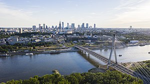
Holy Cross Bridge
Bridge in Warsaw, Poland
Distance: Approx. 217 meters
Latitude and longitude: 52.24194444,21.035
The Holy Cross Bridge (Polish: most Świętokrzyski) is a bridge over the Vistula river in Warsaw, Poland linking Powiśle neighborhood with Praga Północ district. It is a cable-stayed bridge, 479 m long, with two lanes for vehicles, a pavement and a cycle path each way. The single tower, 90 m high, located on the right (eastern) river bank, has 48 cables attached supporting the deck.
Copernicus Science Centre
Science museum in Warsaw, Poland
Distance: Approx. 522 meters
Latitude and longitude: 52.24194444,21.02833333
Copernicus Science Centre (Polish: Centrum Nauki Kopernik) is a science museum standing on the bank of the Vistula River in Warsaw, Poland. It contains over 450 interactive exhibits that enable visitors to single-handedly carry out experiments and discover the laws of science for themselves. The centre is the largest institution of its type in Poland and one of the most advanced in Europe.

Asia and Pacific Museum
Distance: Approx. 784 meters
Latitude and longitude: 52.23305556,21.03722222
The Asia and Pacific Museum (Polish: Muzeum Azji i Pacyfiku), in Warsaw, Poland, was founded in 1973 from a private collection of Oriental art amassed by Andrzej Wawrzyniak, sailor, diplomat, and connoisseur–collector of Oriental art. After returning to Poland, he donated his collection, numbering over 3,000 objects, to Poland. Thus the Museum of the Nusantara Archipelago was created in Warsaw in 1973.

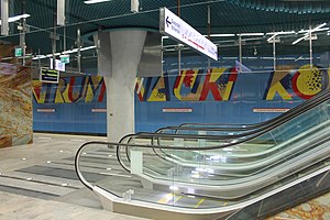
Centrum Nauki Kopernik metro station
Warsaw metro station
Distance: Approx. 248 meters
Latitude and longitude: 52.24,21.03166667
Centrum Nauki Kopernik is a station on the central part of Line M2 of the Warsaw Metro. The station fully opened for passenger use on 8 March 2015 as part of the inaugural stretch of Line M2 between Rondo Daszyńskiego and Dworzec Wileński. It was designed by Polish architect Andrzej M. Chołdzyński and constructed by Metroprojekt.

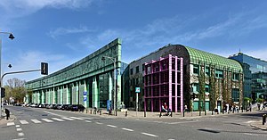
University of Warsaw Library
Distance: Approx. 749 meters
Latitude and longitude: 52.24203333,21.02483333
The University of Warsaw Library (Polish: Biblioteka Uniwersytecka w Warszawie, BUW) is a library of the University of Warsaw, Poland. Established in 1816 following the formation of the Royal Warsaw University, it was led by the first director Samuel Linde, a linguist and educator. By 1831, the library housed over 134,000 volumes.
Warszawa Stadion railway station
Railway station in Warsaw, Poland
Distance: Approx. 767 meters
Latitude and longitude: 52.24444444,21.04388889
Warszawa Stadion, in English Warsaw Stadium, is a railway station in Warsaw, Poland, located in the district of Praga-Południe close to the Kazimierz Górski National Stadium (Stadion Narodowy). The station has two side platforms flanking the suburban tracks of the Warsaw Cross-City Line. The platforms are used by regional trains run by Koleje Mazowieckie and Szybka Kolej Miejska.

Cross-City Bridge
Bridge in Warsaw
Distance: Approx. 198 meters
Latitude and longitude: 52.23883333,21.0375
The Cross-City Bridge (Polish: Most średnicowy) is a rail bridge over the Vistula River in Warsaw, north of the Poniatowski Bridge. It forms a part of the Warsaw Cross-City Line and was originally built between 1921 and 1931 to connect the (now defunct) Warszawa Główna railway station and what is now the Warszawa Wschodnia railway station.
Weather in this IP's area
overcast clouds
4 Celsius
1 Celsius
3 Celsius
6 Celsius
1036 hPa
88 %
1036 hPa
1027 hPa
10000 meters
4.12 m/s
80 degree
100 %
06:44:33
15:54:45

