Country:
 Portugal
Region:
City:
Latitude and Longitude:
Time Zone:
Postal Code:
IP information under different IP Channel
ip-api
Country
Region
City
ASN
Time Zone
ISP
Blacklist
Proxy
Latitude
Longitude
Postal
Route
IPinfo
Country
Region
City
ASN
Time Zone
ISP
Blacklist
Proxy
Latitude
Longitude
Postal
Route
MaxMind
Country
Region
City
ASN
Time Zone
ISP
Blacklist
Proxy
Latitude
Longitude
Postal
Route
Luminati
Country
PTRegion
06
City
coimbra
ASN
Time Zone
Europe/Lisbon
ISP
Nos Comunicacoes, S.A.
Latitude
Longitude
Postal
db-ip
Country
Region
City
ASN
Time Zone
ISP
Blacklist
Proxy
Latitude
Longitude
Postal
Route
ipdata
Country
Region
City
ASN
Time Zone
ISP
Blacklist
Proxy
Latitude
Longitude
Postal
Route
Popular places and events near this IP address
Afife
Civil parish in Norte, Portugal
Distance: Approx. 3631 meters
Latitude and longitude: 41.779,-8.861
Afife is a civil parish located in the Portuguese municipality of Viana do Castelo. The population in 2011 was 1,632, in an area of 13.03 km2.
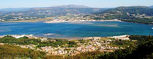
Caminha
Municipality in Norte, Portugal
Distance: Approx. 2953 meters
Latitude and longitude: 41.83333333,-8.83333333
Caminha (Portuguese pronunciation: [kɐˈmiɲɐ] ) is a municipality in the north-west of Portugal, 21 km north from Viana do Castelo, located in the Viana do Castelo District. The population in 2011 was 16,684, in an area of 136.52 km². Caminha is subdivided into 14 civil parishes.

Minho (river)
River in Portugal and Spain
Distance: Approx. 6364 meters
Latitude and longitude: 41.86666667,-8.87
The Minho ( MEEN-yoo; Portuguese: [ˈmiɲu]) or Miño ( MEEN-yoh; Spanish: [ˈmiɲo] ; Galician: [ˈmiɲʊ]; Proto-Celtic: *Miniu) is the longest river in the autonomous community of Galicia in Spain, with a length of 340 kilometres (210 mi). It forms a part of the international border between Spain and Portugal. By discharge volume, it is the fourth largest river of the Iberian Peninsula after the Douro, Ebro, and Tagus rivers.
Castro of Vieito
Portuguese archaeological site
Distance: Approx. 9706 meters
Latitude and longitude: 41.73065,-8.80716111
The Castro of Vieito (Portuguese: Castro do Vieito) is an archaeological site of the Castro culture of northwestern Iberian Peninsula, situated on the right margin of the Lima River estuary, in the civil parish of Perre, municipality of Viana do Castelo.

Ponte de Vilar de Mouros
Bridge in Viana do Castelo District, Portugal
Distance: Approx. 9995 meters
Latitude and longitude: 41.8875,-8.78944444
Vilar de Mouros Bridge crosses the Coura river in Vilar de Mouros, Portugal. It was classified as a National Monument in 1910.
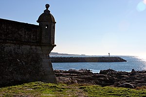
Fort of Lagarteira
Distance: Approx. 1371 meters
Latitude and longitude: 41.81552778,-8.86791667
The Fort of Lagarteira (Portuguese: Forte de Âncora/Forte da Lagarteira) is a medieval fort in the civil parish of Vila Praia de Âncora, municipality of Caminha in the Portuguese Norte, classified as a Property of Public Interest (Imóvel de Interesse Público).

Igreja Matriz de Caminha
Distance: Approx. 7550 meters
Latitude and longitude: 41.87805556,-8.83888889
Igreja Matriz de Caminha is a church in Portugal. It is classified as a National Monument.

Cividade de Âncora
Archaeological site in Viana do Castelo, Portugal
Distance: Approx. 2112 meters
Latitude and longitude: 41.79205556,-8.85125
The Cividade de Âncora (also known as Cividade de Afife) is an archaeological site of the Castro culture located in the border between the municipalities of Viana do Castelo (Afife) and Vila Praia de Âncora. The Cividade was built during the Iron Age (2nd Century BCE) and was occupied up to the Romanization of Hispania (1st Century CE). Despite no evidence of occupation after the Roman period, two Stelae belonging to the Middle Ages were found in the area.
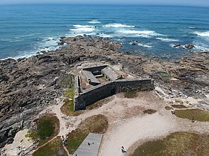
Fort of Cão
Distance: Approx. 2303 meters
Latitude and longitude: 41.79777778,-8.87388889
The Fort of Cão (Forte do Cão in Portuguese), also referred to as Fortlet of Cão (Fortim do Cão in Portuguese), is located in the place of Gelfa, by the Gelfa Beach and Gelfa Woodland, south of the village and parish of Âncora, in the municipality of Caminha, district of Viana do Castelo, in Portugal.
Montedor Fort
Distance: Approx. 6129 meters
Latitude and longitude: 41.75888889,-8.87638889
The Montedor Fort (Forte de Montedor in Portuguese), also referred to as Montedor Fortlet (Fortim de Montedor in Portuguese) or Paçô Fort (Forte de Paçô in Portuguese), is located on Paçô beach, in the parish of Carreço, municipality of Viana do Castelo, in Portugal. It is classified as a Property of Public Interest by Decree No. 47,508, published in DG No.

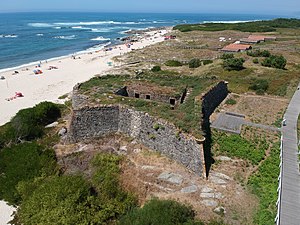
Areosa Fort
Distance: Approx. 2303 meters
Latitude and longitude: 41.79777778,-8.87388889
the Areosa Fort (Forte da Areosa in Portuguese), also referred to as Areosa Fortlet (Fortim da Areosa in Portuguese), is located in the place of Rego de Fontes, by the bay of Vinha, in the village and parish of Areosa, in the municipality of Caminha, district of Viana do Castelo, in Portugal. It is classified as a "Property of Public Interest" since 1970.

Montedor Lighthouse
Lighthouse in Portugal
Distance: Approx. 7042 meters
Latitude and longitude: 41.75,-8.875
The Montedor Lighthouse (Portuguese: Farol de Montedor) is located on the Atlantic Ocean on a promontory in the parish of Carreço in the municipality of Viana do Castelo in Portugal. It is the northernmost lighthouse in Portugal, situated 4 nautical miles (7.4 km; 4.6 mi) north of the mouth of the Lima River and 7 nautical miles (13 km; 8.1 mi) south of the mouth of the Minho River. It was opened on 20 March 1910.
Weather in this IP's area
light rain
18 Celsius
19 Celsius
18 Celsius
18 Celsius
1020 hPa
96 %
1020 hPa
1017 hPa
10000 meters
2.15 m/s
2.26 m/s
176 degree
100 %
07:31:24
19:19:02