78.129.71.85 - IP Lookup: Free IP Address Lookup, Postal Code Lookup, IP Location Lookup, IP ASN, Public IP
Country:
Region:
City:
Location:
Time Zone:
Postal Code:
ISP:
ASN:
language:
User-Agent:
Proxy IP:
Blacklist:
IP information under different IP Channel
ip-api
Country
Region
City
ASN
Time Zone
ISP
Blacklist
Proxy
Latitude
Longitude
Postal
Route
db-ip
Country
Region
City
ASN
Time Zone
ISP
Blacklist
Proxy
Latitude
Longitude
Postal
Route
IPinfo
Country
Region
City
ASN
Time Zone
ISP
Blacklist
Proxy
Latitude
Longitude
Postal
Route
IP2Location
78.129.71.85Country
Region
hainaut
City
charleroi
Time Zone
Europe/Brussels
ISP
Language
User-Agent
Latitude
Longitude
Postal
ipdata
Country
Region
City
ASN
Time Zone
ISP
Blacklist
Proxy
Latitude
Longitude
Postal
Route
Popular places and events near this IP address

Stade du Pays de Charleroi
Football stadium in Charleroi, Belgium
Distance: Approx. 749 meters
Latitude and longitude: 50.414609,4.453787
Stade du Pays de Charleroi is a football stadium in the city of Charleroi, Belgium. It was built for the 2000 UEFA European Championship in Belgium and the Netherlands in replacement of the old stadium known as Mambourg. The name Stade du Mambourg officially changed in front of 25,000 spectators on 24 May 1999 during the inaugural match between Sporting and Metz.

Lodelinsart
Former municipality of Belgium in Wallonia
Distance: Approx. 704 meters
Latitude and longitude: 50.41666667,4.45
Lodelinsart (Walloon: Lodlinsåt) is a town of Wallonia and a district of the municipality of Charleroi, located in the province of Hainaut, Belgium. It was a municipality of its own before the fusion of the Belgian municipalities in 1977.
Charleroi-West railway station
Railway station in Hainaut, Belgium
Distance: Approx. 583 meters
Latitude and longitude: 50.41055556,4.43638889
Charleroi-West railway station (French: Gare de Charleroi-Ouest; Dutch: Station Charleroi-West) is a secondary railway station serving Charleroi, Hainaut, Belgium. It is one of two railway stations located in downtown Charleroi, the other one being the much larger Charleroi-Central railway station. It is operated by the National Railway Company of Belgium (SNCB/NMBS).
Palais metro station
Chareloi metro station
Distance: Approx. 384 meters
Latitude and longitude: 50.41472222,4.44305556
Palais (French pronunciation: [palɛ] , lit. 'Palace'), formerly Beaux-Arts (pronounced [boz‿aʁ] , lit. 'Fine arts'), is the largest station in the Charleroi Metro network, located in Charleroi downtown, in fare zone 1. Because of its situation on a slope, the station terminates on a viaduct at one end (toward Ouest and Piges), and in a tunnel at the other end (toward Waterloo). The station has two street entrances leading to a mezzanine level where ticket counters and shops are located.

Piges metro station
Metro station in Charleroi, Belgium
Distance: Approx. 673 meters
Latitude and longitude: 50.41527778,4.43722222
Piges (French pronunciation: [piʒ] ) is a Charleroi Metro station, located in Dampremy (part of the Charleroi municipality), in fare zone 1. The station is built on a viaduct and is accessed through escalators and stairs from a street entrance located on Chaussée de Bruxelles (Brussels Road). Although the station is built on a viaduct, tracks enter a tunnel at its western end, as they pass under a spoil tip (Terril des Piges) toward Dampremy.

Parc metro station (Charleroi)
Metro station in Charleroi, Belgium
Distance: Approx. 364 meters
Latitude and longitude: 50.40944444,4.44861111
Parc (French pronunciation: [paʁk] ) is a Charleroi Metro station, located in downtown Charleroi, in fare zone 1. It is an underground station with a central platform accessible from the street at both ends. Interior decoration, themed around the Lucky Luke Belgian comics character, features a fresco of the comics main characters on one side, and a short comics strip depicting a train attack by the Daltons on the other side.
Janson metro station
Metro station in Charleroi, Belgium
Distance: Approx. 559 meters
Latitude and longitude: 50.41305556,4.45194444
Janson is a Charleroi Metro station, located in downtown Charleroi, Belgium, in fare zone 1. It is an underground station featuring a central platform, with street access at both ends. Interior decoration, designed by architect Jean Yernaux, is themed around the Belgian comics characters from Dupuis Publishing, a well-known Belgian comics publishing company based in Marcinelle (part of the Charleroi municipality).
Tirou metro station
Metro station in Charleroi, Belgium
Distance: Approx. 594 meters
Latitude and longitude: 50.40611111,4.44555556
Tirou (French pronunciation: [tiʁu]) is a Charleroi Metro station, located in downtown Charleroi, in fare zone 1. Tirou is an open-air station located at street level (Rue de l'écluse) and offers same-platform bus transfer. The station's lateral platform are publicly accessible and serve as regular street sidewalks.

2016 stabbing of Charleroi police officers
Terrorist attack in Charleroi, Belgium
Distance: Approx. 649 meters
Latitude and longitude: 50.412,4.4536
On 6 August 2016, a man attacked two police officers with a machete in Charleroi, Belgium, before being shot dead by another police officer.

Athénée Royal Vauban
School in Charleroi, Belgium
Distance: Approx. 210 meters
Latitude and longitude: 50.4118,4.4474
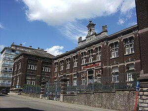
Athénée Royal Vauban is a Francophone secondary school in Charleroi, Belgium. For much of its history it was a school for girls, originating from a private school opened by Mrs Dupuis in 1831. The royal decree of 26 Septembre 1881 created a state school for girls, Ecole Moyenne de l'Etat pour Demoiselles.

Maison Mattot
Modernist residential building in Charleroi, Belgium
Distance: Approx. 709 meters
Latitude and longitude: 50.41583333,4.45166667
The Maison Mattot is a modernist-style residential building on Frans Dewandre Boulevard in Charleroi, Belgium. It was designed in 1937 by architect Marcel Leborgne for the Reine Astrid Maternity Hospital's director, Dr. Mattot.

Digue Square
Square in Charleroi, Belgium
Distance: Approx. 498 meters
Latitude and longitude: 50.40955,4.4381091
The Digue Square and Digue Street are located in the lower town of Charleroi, Belgium. The triangular-shaped square rises from Dampremy Street in the east to Grand Central Street in the west. Before the works, it was a paved parking lot; since May 2014, it has been a pedestrian space above an underground parking lot.
Weather in this IP's area
clear sky
5 Celsius
5 Celsius
5 Celsius
5 Celsius
1021 hPa
62 %
1021 hPa
1000 hPa
10000 meters
0.86 m/s
1.12 m/s
246 degree


