Country:
 Italy
ItalyRegion:
City:
Latitude and Longitude:
Time Zone:
Postal Code:
IP information under different IP Channel
ip-api
Country
Region
City
ASN
Time Zone
ISP
Blacklist
Proxy
Latitude
Longitude
Postal
Route
IPinfo
Country
Region
City
ASN
Time Zone
ISP
Blacklist
Proxy
Latitude
Longitude
Postal
Route
MaxMind
Country
Region
City
ASN
Time Zone
ISP
Blacklist
Proxy
Latitude
Longitude
Postal
Route
Luminati
Country
ITASN
Time Zone
Europe/Rome
ISP
TIM
Latitude
Longitude
Postal
db-ip
Country
Region
City
ASN
Time Zone
ISP
Blacklist
Proxy
Latitude
Longitude
Postal
Route
ipdata
Country
Region
City
ASN
Time Zone
ISP
Blacklist
Proxy
Latitude
Longitude
Postal
Route
Popular places and events near this IP address
Rubicon
River in northeastern Italy
Distance: Approx. 672 meters
Latitude and longitude: 44.1681,12.4431
The Rubicon (Latin: Rubico; Italian: Rubicone [rubiˈkoːne]; Romagnol: Rubicôn [rubiˈkoːŋ]) is a shallow river in northeastern Italy, just south of Cesena and north of Rimini. It was known as Fiumicino until 1933, when it was identified with the ancient river Rubicon, famously crossed by Julius Caesar in 49 BC. The river flows for around 80 km (50 mi) from the Apennine Mountains to the Adriatic Sea through the south of the Emilia-Romagna region, between the towns of Rimini and Cesena.
Bellaria – Igea Marina
Comune in Emilia-Romagna, Italy
Distance: Approx. 2579 meters
Latitude and longitude: 44.15,12.45
Bellaria – Igea Marina (Romagnol: Belària – Igea Maròina) is a town and comune in the province of Rimini, northern Italy, with approximately 18,300 inhabitants.
Gatteo
Comune in Emilia-Romagna, Italy
Distance: Approx. 8906 meters
Latitude and longitude: 44.1,12.38333333
Gatteo (Romagnol: Gatì) is a comune (municipality) in the Province of Forlì-Cesena in the Italian region Emilia-Romagna, located about 90 kilometres (56 mi) southeast of Bologna and about 30 kilometres (19 mi) southeast of Forlì. As of 31 December 2004, it had a population of 7,252 and an area of 14.1 square kilometres (5.4 sq mi). Gatteo borders the following municipalities: Cesenatico, Gambettola, Longiano, Savignano sul Rubicone.

San Mauro Pascoli
Comune in Emilia-Romagna, Italy
Distance: Approx. 8013 meters
Latitude and longitude: 44.1,12.41666667
San Mauro Pascoli (Romagnol: San Mevar) is a comune (municipality) in the Province of Forlì-Cesena in the Italian region Emilia-Romagna, located about 100 kilometres (62 mi) southeast of Bologna and about 35 kilometres (22 mi) southeast of Forlì. It is at some 7.5 kilometres (4.7 mi) from the sea, the frazione of San Mauro Mare facing it. The comune was called San Mauro di Romagna until 1932, when its name was changed in honor of the poet Giovanni Pascoli and his beloved sister Maria, who were born here.

Savignano sul Rubicone
Comune in Emilia-Romagna, Italy
Distance: Approx. 8366 meters
Latitude and longitude: 44.1,12.4
Savignano sul Rubicone (Romagnol: Savgnèn) is a comune (municipality) in the Province of Forlì-Cesena in the Italian region Emilia-Romagna, located about 90 kilometres (56 mi) southeast of Bologna and about 30 kilometres (19 mi) southeast of Forlì. The comune takes its name from the Rubicon, famous for Julius Caesar's historic crossing. A combination of natural and man-made changes caused the original Rubicon to change course repeatedly.

Crossing the Rubicon
Idiom to mean a point of no return
Distance: Approx. 9207 meters
Latitude and longitude: 44.093,12.396
The phrase "crossing the Rubicon" is an idiom that means "passing a point of no return". Its meaning comes from allusion to the crossing of the river Rubicon from the north by Julius Caesar in early January 49 BC. The exact date is unknown. Scholars usually place it on the night of 10 and 11 January because of the speeds at which messengers could travel at that time.
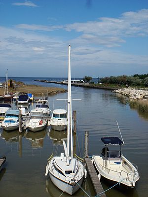
Battle of Cesenatico
1815 battle during the Neapolitan War
Distance: Approx. 4156 meters
Latitude and longitude: 44.19901111,12.40156111
The Battle of Cesenatico was a minor battle in the Neapolitan War that took place on 23 April 1815 in the town of Cesenatico on Adriatic coast. The main Neapolitan army, commanded by their king, Joachim Murat, was retreating to their original headquarters in Ancona following a string a defeats in northern Italy. The Neapolitans were being pursued by an Austrian corps under the command of Adam Albert von Neipperg.

Cesenatico Lighthouse
Lighthouse
Distance: Approx. 4783 meters
Latitude and longitude: 44.206108,12.401554
Cesenatico Lighthouse (Italian: Faro di Cesenatico) is an active lighthouse located on the south-west of the entrance to the channel-harbour of Cesenatico, Emilia-Romagna on the Adriatic Sea.

Ponte di San Vito
Roman bridge near Rimini, Italy
Distance: Approx. 9476 meters
Latitude and longitude: 44.08656111,12.45346944
The Roman Bridge of San Vito (Italian: Ponte romano di San Vito), also locally known as the Pontaccio (Romagnol: e Puntaz, lit. 'ugly bridge'), was a Roman bridge in San Vito, a frazione on the borders of Rimini, Santarcangelo di Romagna, and San Mauro Pascoli, in the region of Emilia-Romagna, northern Italy. Dating to the reign of emperor Augustus, the bridge was on a route of the Via Aemilia, the ancient Roman road running between Ariminum (modern Rimini) and Placentia (Piacenza). The bridge crossed the river Uso, which now flows a few metres to the east.

San Vito, Emilia-Romagna
Town in Romagna, Italy
Distance: Approx. 9854 meters
Latitude and longitude: 44.08365,12.45785
San Vito is a town in Emilia-Romagna, northern Italy. The town is divided between the comuni of Rimini and Santarcangelo di Romagna, both in the Province of Rimini, with a northern part in San Mauro Pascoli, in the Province of Forlì-Cesena. Culturally, the town is closest to Santarcangelo.
Weather in this IP's area
overcast clouds
19 Celsius
20 Celsius
19 Celsius
20 Celsius
1015 hPa
92 %
1015 hPa
1015 hPa
10000 meters
2.68 m/s
8.49 m/s
72 degree
100 %
07:30:11
18:19:50