Country:
 Great Britain
Region:
City:
Latitude and Longitude:
Time Zone:
Postal Code:
IP information under different IP Channel
ip-api
Country
Region
City
ASN
Time Zone
ISP
Blacklist
Proxy
Latitude
Longitude
Postal
Route
IPinfo
Country
Region
City
ASN
Time Zone
ISP
Blacklist
Proxy
Latitude
Longitude
Postal
Route
MaxMind
Country
Region
City
ASN
Time Zone
ISP
Blacklist
Proxy
Latitude
Longitude
Postal
Route
Luminati
Country
GBRegion
eng
City
sheffield
ASN
Time Zone
Europe/London
ISP
ASK4 Limited
Latitude
Longitude
Postal
db-ip
Country
Region
City
ASN
Time Zone
ISP
Blacklist
Proxy
Latitude
Longitude
Postal
Route
ipdata
Country
Region
City
ASN
Time Zone
ISP
Blacklist
Proxy
Latitude
Longitude
Postal
Route
Popular places and events near this IP address
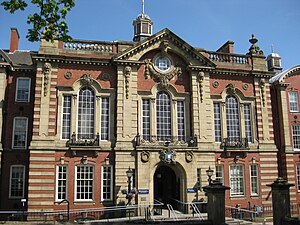
Sir Frederick Mappin Building
Distance: Approx. 241 meters
Latitude and longitude: 53.38196,-1.47929
The Sir Frederick Mappin Building, or more familiarly the Mappin Building, is a Grade II listed building fronting onto Mappin Street, Sheffield, England, part of the University of Sheffield. The building and street (formerly Charlotte Street) are named after Sir Frederick Mappin (1821–1910), the so-called Father of Sheffield University.

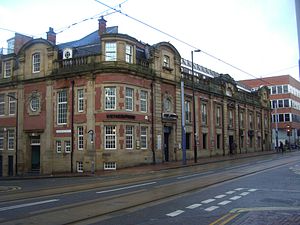
Devonshire Quarter
Distance: Approx. 132 meters
Latitude and longitude: 53.379393,-1.478595
The Devonshire Quarter is an area in the centre of Sheffield, England. Its heart is the Division Street and Devonshire Street shopping areas, known for their small independent shops and variety of pubs and bars. The district also has The Forum shopping centre and Devonshire Green, one of the largest open areas in central Sheffield.

St George's Church, Portobello
Distance: Approx. 202 meters
Latitude and longitude: 53.3817,-1.4808
St George's Church, Portobello, is a former Church of England parish church in the City of Sheffield, England. It is now part of the University of Sheffield and is a lecture theatre and student housing. St George's is the first of three Commissioners' churches to have been built in Sheffield under the Church Building Act 1818.
Glossop Road Baths
Distance: Approx. 107 meters
Latitude and longitude: 53.3798,-1.482
Glossop Road Baths is a building in Sheffield, South Yorkshire, England, which originally housed a swimming pool and Victorian Turkish baths. The first public baths in the city were opened on the site in 1836, following the cholera epidemic of 1832. The complex was rebuilt from 1877 to 1879 to a design by E. M. Gibbs, including an indoor swimming pool was opened, a Turkish bath suite and a hairdresser.

Jessop Hospital
Hospital in South Yorkshire, England
Distance: Approx. 239 meters
Latitude and longitude: 53.3816,-1.4826
The Jessop Hospital for Women was a hospital in Sheffield, South Yorkshire, England. At the time of its closure in 2001, it was managed by the Central Sheffield University Hospitals NHS Trust.

West One
Mixed-use development in Sheffield, South Yorkshire, England
Distance: Approx. 80 meters
Latitude and longitude: 53.379188,-1.480494
West One is also the name of a retail park in Salford. West One is a mixed-use development at the centre of the Devonshire Quarter in the city centre of Sheffield, South Yorkshire, England. It comprises bars, restaurants and shops at ground-level (including the large Revolution bar) and apartments housing over 1,000 people above, including a penthouse.

Division Street, Sheffield
Street in Sheffield, South Yorkshire, England
Distance: Approx. 132 meters
Latitude and longitude: 53.379393,-1.478595
Division Street is a street and shopping area located in the Devonshire Quarter of Sheffield, England. It is home to many small independent shops, a few large ones such as Costa Coffee and Sainsburys Local, and a few local pubs such as the Frog & Parrot, as well as a Lloyd's No. 1 bar.

Devonshire Green
Distance: Approx. 178 meters
Latitude and longitude: 53.3789,-1.4783
Devonshire Green is a small public open space at 53.3789°N 1.4783°W / 53.3789; -1.4783 within Sheffield city centre in South Yorkshire, England. It covers an area of approximately 9000 square metres and is designated as a district park by Sheffield City Council. It stands in the Devonshire Quarter of the city centre, bordered on its four sides by Devonshire Street, Fitzwilliam Street, Eldon Street and Wellington Street.

Somme Barracks, Sheffield
Barracks in South Yorkshire, UK
Distance: Approx. 217 meters
Latitude and longitude: 53.38027778,-1.48361111
Somme Barracks, Sheffield is a military establishment on Glossop Road in Sheffield, England. The building is owned by the Ministry of Defence and serves as the base of the University of Sheffield Officers' Training Corps, which has been a part of the Yorkshire Officer Training Regiment since 2011. It is a Grade II listed building.

The Diamond, Sheffield
Building at the University of Sheffield, England
Distance: Approx. 199 meters
Latitude and longitude: 53.38154,-1.4816
The Diamond is a building in Sheffield, South Yorkshire, part of the University of Sheffield. Housing specialist engineering facilities as well as seminar room and open plan study spaces, it was completed in September 2015 at a cost of £81 million, the largest capital investment ever made by the university. It is situated on Leavygreave Road, between the Jessop Wing and St George's Church.

Department of Archaeology, University of Sheffield
Distance: Approx. 57 meters
Latitude and longitude: 53.3804,-1.4806
The Department of Archaeology at the University of Sheffield, UK, is an academic department providing undergraduate and postgraduate courses in archaeology and its sub-disciplines based in the city of Sheffield, South Yorkshire. It conducts archaeological associated research with several dedicated research centres. It was founded in 1976, stemming from early archaeology programs in the 1960s as one of the first universities in the UK with a dedicated Department of Archaeology.
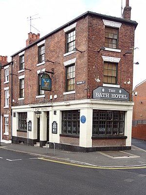
Bath Hotel, Sheffield
Distance: Approx. 144 meters
Latitude and longitude: 53.37923,-1.48225
The Bath Hotel is a pub in Broomhall district of Sheffield, in England. The building was built in about 1868, as a grocers' shop at the end of a terrace of houses, on Victoria Street. The grocery also operated as a beerhouse, and it was sold to Ind Coope in 1914.
Weather in this IP's area
overcast clouds
11 Celsius
9 Celsius
10 Celsius
12 Celsius
993 hPa
34 %
993 hPa
982 hPa
10000 meters
1.11 m/s
1.24 m/s
87 degree
86 %
07:20:21
18:26:06