77.92.119.155 - IP Lookup: Free IP Address Lookup, Postal Code Lookup, IP Location Lookup, IP ASN, Public IP
Country:
Region:
City:
Location:
Time Zone:
Postal Code:
ISP:
ASN:
language:
User-Agent:
Proxy IP:
Blacklist:
IP information under different IP Channel
ip-api
Country
Region
City
ASN
Time Zone
ISP
Blacklist
Proxy
Latitude
Longitude
Postal
Route
db-ip
Country
Region
City
ASN
Time Zone
ISP
Blacklist
Proxy
Latitude
Longitude
Postal
Route
IPinfo
Country
Region
City
ASN
Time Zone
ISP
Blacklist
Proxy
Latitude
Longitude
Postal
Route
IP2Location
77.92.119.155Country
Region
kayseri
City
kayseri
Time Zone
Europe/Istanbul
ISP
Language
User-Agent
Latitude
Longitude
Postal
ipdata
Country
Region
City
ASN
Time Zone
ISP
Blacklist
Proxy
Latitude
Longitude
Postal
Route
Popular places and events near this IP address

Kayseri
Metropolitan municipality in Central Anatolia, Turkey
Distance: Approx. 1037 meters
Latitude and longitude: 38.7225,35.4875
Kayseri (Turkish pronunciation: [ˈkajseɾi]) is a large city in Central Anatolia, Turkey, and the capital of Kayseri province. Historically known as Caesarea, it has been the historical capital of Cappadocia since ancient times. The Kayseri Metropolitan Municipality area is composed of five districts: the two central districts of Kocasinan and Melikgazi, and since 2004, also outlying Hacılar, İncesu, and Talas.
Kayseri Atatürk Stadium
Distance: Approx. 1360 meters
Latitude and longitude: 38.72305556,35.49666667
Kayseri Atatürk Stadium, opened in 1960, was a multi-purpose stadium in Kayseri, Turkey. It was mainly used for football matches, and was shared by the two largest clubs in the region, Kayserispor who currently play in the Süper Lig and Kayseri Erciyesspor who became dissolved. The stadium was able to hold 25,918 seated people, and was mostly uncovered.

Kocasinan
District and municipality in Kayseri, Turkey
Distance: Approx. 268 meters
Latitude and longitude: 38.73333333,35.48333333
Kocasinan is a municipality and district of Kayseri Province, Turkey. Its area is 1,471 km2, and its population is 409,005 (2022). It covers the northern part of the agglomeration of Kayseri and the adjacent countryside.

Melikgazi
District and municipality in Kayseri, Turkey
Distance: Approx. 2089 meters
Latitude and longitude: 38.71666667,35.5
Melikgazi is a municipality and district of Kayseri Province, Turkey. Its area is 668 km2, and its population is 594,344 (2022). It covers the southern and eastern part of the agglomeration of Kayseri and the adjacent countryside.
Kayseri Atatürk Stadium disaster
Distance: Approx. 1360 meters
Latitude and longitude: 38.723056,35.496667
The Kayseri Atatürk Stadium disaster refers to an occurrence of football hooliganism, resulting in 43 deaths and at least 300 injuries (according to newspaper Hürriyet's headline 600), during the football match held on September 17, 1967 between the clubs of Kayserispor and Sivasspor at the Atatürk Stadium of Kayseri in Turkey. It was known as the worst sports-related violence to occur in Turkey.

Kayseri Castle
Castle in Kayseri, Turkey
Distance: Approx. 1221 meters
Latitude and longitude: 38.7211,35.4892
Kayseri Castle is a castle built in antiquity and first mentioned in a coin during the rule of Gordian III between 238 and 244 AD. It went through multiple additions starting with the Romans, continuing with the Byzantines, Danishmends, Seljuqs, Dulqadirs, Karamanids, and Ottomans. The castle, located in the eponymous city, is made of an inner and an outer section with a total of 18 towers.
Kayseri railway station
Railway station in Turkey
Distance: Approx. 684 meters
Latitude and longitude: 38.7304,35.4779
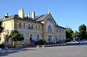
Kayseri station is the main station in Kayseri, Turkey. It is on Kocasinan Boulevard in the Kocasinan second level municipality of Kayseri at 38°43′49″N 35°28′41″E. The station was built in 1927. It is an important junction for those trains to East Anatolia.
Kayseri Archaeology Museum
Museum in Kayseri, Turkey
Distance: Approx. 1177 meters
Latitude and longitude: 38.72138889,35.48861111
Kayseri Archaeology Museum is a museum in Kayseri, Turkey. Kayseri Archeology Museum, which has been serving here for about 50 years, has been moved to the new museum building within the Kayseri Castle and has been opened to visitors since 19 October 2019. In the new museum, there are 14 exhibition halls in chronological order.

Hunat Hatun Complex
Islamic religious complex in Turkey
Distance: Approx. 1321 meters
Latitude and longitude: 38.72055556,35.49083333
The Hunat Hatun Complex is a historic Islamic religious complex in Kayseri, Turkey. Early in the 13th century, Kayqubad I, Sultan of the Anatolian Selçuks (1219–1237), captured the Alanya fortress (then called Kalon Oros, later renamed Ala'iyya) from its Armenian ruler, Kir Vart. One of the conditions of Vart's surrender was that his daughter Hunat (“lady” in Persian) Mahperi Hatun would become the sultan's wife.

Caesarea (Mazaca)
Ancient city in Asia-Minor, predecessor to modern Kayseri
Distance: Approx. 1037 meters
Latitude and longitude: 38.7225,35.4875
Caesarea (/ˌsɛzəˈriːə, ˌsɛsəˈriːə, ˌsiːzəˈriːə/; Greek: Καισάρεια, romanized: Kaisareia), also known historically as Mazaca (Greek: Μάζακα), was an ancient city in what is now Kayseri, Turkey. In Hellenistic and Roman times, the city was an important stop for merchants headed to Europe on the ancient Silk Road. The city was the capital of Cappadocia, and Armenian and Cappadocian kings regularly fought over control of the strategic city.
Köşkmedrese
Historic building in Kayseri, Turkey
Distance: Approx. 2745 meters
Latitude and longitude: 38.71657,35.51056
Köşkmedrese is a khanqah located on Mount Köşk to the southeast of the city of Kayseri in central Turkey. According to the inscriptions on the building that ceased to exist, it was built by Eretna in memory of his consort Suli Pasha in 1339. Although originally a khanqah, it was later known and used as a madrasa.

Sahabiye Madrasa
13th-century madrasa in Kayseri, Turkey
Distance: Approx. 932 meters
Latitude and longitude: 38.72338611,35.48685
Sahabiye Madrasa (Turkish: Sahabiye Medresesi) is a historical 13th-century madrasa in Kayseri, Turkey.
Weather in this IP's area
clear sky
1 Celsius
-1 Celsius
1 Celsius
1 Celsius
1025 hPa
69 %
1025 hPa
884 hPa
10000 meters
2.06 m/s
60 degree

