Country:
 Germany
Region:
City:
Latitude and Longitude:
Time Zone:
Postal Code:
IP information under different IP Channel
ip-api
Country
Region
City
ASN
Time Zone
ISP
Blacklist
Proxy
Latitude
Longitude
Postal
Route
IPinfo
Country
Region
City
ASN
Time Zone
ISP
Blacklist
Proxy
Latitude
Longitude
Postal
Route
MaxMind
Country
Region
City
ASN
Time Zone
ISP
Blacklist
Proxy
Latitude
Longitude
Postal
Route
Luminati
Country
DEASN
Time Zone
Europe/Berlin
ISP
Nerdscave
Latitude
Longitude
Postal
db-ip
Country
Region
City
ASN
Time Zone
ISP
Blacklist
Proxy
Latitude
Longitude
Postal
Route
ipdata
Country
Region
City
ASN
Time Zone
ISP
Blacklist
Proxy
Latitude
Longitude
Postal
Route
Popular places and events near this IP address
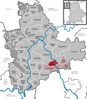
Main-Spessart
District in Bavaria, Germany
Distance: Approx. 4812 meters
Latitude and longitude: 49.92,9.75
Main-Spessart is a Landkreis (district) in the northwest of Bavaria, Germany. It is located in Lower Franconia and derives its name from the river Main and the wooded hills of the Spessart.

Karlstadt am Main
Town in Bavaria, Germany
Distance: Approx. 92 meters
Latitude and longitude: 49.96027778,9.77222222
Karlstadt is a town in the Main-Spessart in the Regierungsbezirk of Lower Franconia (Unterfranken) in Bavaria, Germany. It is the administrative centre of Main-Spessart (Kreisstadt), and has a population of around 15,000.

Eußenheim
Municipality in Bavaria, Germany
Distance: Approx. 4004 meters
Latitude and longitude: 49.98333333,9.81666667
Eußenheim (or Eussenheim) is a community in the Main-Spessart district in the Regierungsbezirk of Lower Franconia (Unterfranken) in Bavaria, Germany.

Gössenheim
Municipality in Bavaria, Germany
Distance: Approx. 6292 meters
Latitude and longitude: 50.01666667,9.78333333
Gössenheim is a community in the Main-Spessart district in the Regierungsbezirk of Lower Franconia (Unterfranken) in Bavaria, Germany and a member of the Verwaltungsgemeinschaft (Administrative Community) of Gemünden am Main.
Himmelstadt
Municipality in Bavaria, Germany
Distance: Approx. 5237 meters
Latitude and longitude: 49.91666667,9.8
Himmelstadt is a community in the Main-Spessart district in the Regierungsbezirk of Lower Franconia (Unterfranken) in Bavaria, Germany and a member of the Verwaltungsgemeinschaft (Administrative Community) of Zellingen. Because of the community’s “heavenly” name – Himmel means “heaven” or “sky” in German – the Weihnachtspostamt Himmelstadt (“Himmelstadt Christmas Post Office”) has existed since 1986, jointly run by Deutsche Post and the community.

Steinfeld, Bavaria
Municipality in Bavaria, Germany
Distance: Approx. 7400 meters
Latitude and longitude: 49.95138889,9.67111111
Steinfeld (German pronunciation: [ˈʃtaɪnˌfɛlt]) is a community in the Main-Spessart district in the Regierungsbezirk of Lower Franconia (Unterfranken) in Bavaria, Germany and a member of the Verwaltungsgemeinschaft (Administrative Community) of Lohr am Main. Spoken here is an East Franconian dialect (according to the Language Atlas of the Bavarian Library, Lower East Franconian). The inhabitants are often called Steeflder Russe in the local area.

Thüngen
Municipality in Bavaria, Germany
Distance: Approx. 6486 meters
Latitude and longitude: 49.94222222,9.85944444
Thüngen (German: [ˈtʏŋən] ) is a market community in the Main-Spessart district in the Regierungsbezirk of Lower Franconia (Unterfranken) in Bavaria, Germany and a member of the Verwaltungsgemeinschaft (Administrative Community) of Zellingen.

Zellingen
Municipality in Bavaria, Germany
Distance: Approx. 7412 meters
Latitude and longitude: 49.9,9.81666667
Zellingen is a market community in the Main-Spessart district in the Regierungsbezirk of Lower Franconia (Unterfranken) in Bavaria, Germany and the seat of the Verwaltungsgemeinschaft (Administrative Community) of Zellingen.
Adelsberg (Gemünden am Main)
Ortsteil of Gemünden am Main in Bavaria, Germany
Distance: Approx. 8649 meters
Latitude and longitude: 50.035,9.73916667
Adelsberg is an outlying centre (Stadtteil) of Gemünden am Main in the Main-Spessart district, in Bavaria, Germany. It lies roughly 40 km northwest of Würzburg.

Aschbach (Wern)
River in Germany
Distance: Approx. 4957 meters
Latitude and longitude: 49.9982,9.8103
Aschbach is a river in Lower Franconia, Bavaria, Germany. The source of the Aschbach is in the district of Bad Kissingen, south of the military training ground Hammelburg, near the Bildeiche. It starts southwards, along the street 2294 to Gauaschach, a district of Hammelburg.

Wern
River in Germany
Distance: Approx. 8259 meters
Latitude and longitude: 50.0283,9.7266
The Wern is a river in Bavaria, Germany. It is a right tributary of the river Main, which it joins in Wernfeld.

Karlstadt (Main) station
Railway station in Karlstadt am Main, Germany
Distance: Approx. 479 meters
Latitude and longitude: 49.9629,9.7679
Karlstadt (Main) station (German: Bahnhof Karlstadt (Main)) is a railway station in the municipality of Karlstadt am Main, located in the Main-Spessart district in Bavaria, Germany.
Weather in this IP's area
overcast clouds
15 Celsius
15 Celsius
14 Celsius
16 Celsius
1019 hPa
87 %
1019 hPa
998 hPa
10000 meters
4.36 m/s
6.27 m/s
217 degree
100 %
07:49:22
18:21:56