Country:
Region:
City:
Latitude and Longitude:
Time Zone:
Postal Code:
IP information under different IP Channel
ip-api
Country
Region
City
ASN
Time Zone
ISP
Blacklist
Proxy
Latitude
Longitude
Postal
Route
Luminati
Country
ASN
Time Zone
Europe/London
ISP
Fiberax Networking&Cloud Ltd.
Latitude
Longitude
Postal
IPinfo
Country
Region
City
ASN
Time Zone
ISP
Blacklist
Proxy
Latitude
Longitude
Postal
Route
db-ip
Country
Region
City
ASN
Time Zone
ISP
Blacklist
Proxy
Latitude
Longitude
Postal
Route
ipdata
Country
Region
City
ASN
Time Zone
ISP
Blacklist
Proxy
Latitude
Longitude
Postal
Route
Popular places and events near this IP address

Thames Tunnel
Tunnel crossing under the River Thames in London
Distance: Approx. 485 meters
Latitude and longitude: 51.50305556,-0.05444444
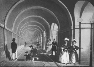
The Thames Tunnel is a tunnel beneath the River Thames in London, connecting Rotherhithe and Wapping. It measures 35 ft (11 m) wide by 20 ft (6.1 m) high and is 1,300 ft (400 m) long, running at a depth of 75 ft (23 m) below the river surface measured at high tide. It is the first tunnel known to have been constructed successfully underneath a navigable river.

Canada Water station
London Underground and London Overground station
Distance: Approx. 304 meters
Latitude and longitude: 51.498333,-0.05
Canada Water is a London Underground and London Overground station located in Canada Water, in south London, England. It takes its name from Canada Water, a lake which was created from a former dock in the Port of London. The station is located on the Jubilee line between Bermondsey and Canary Wharf stations and on the East London line between Rotherhithe and Surrey Quays stations, and provides an interchange point between the two lines.

Rotherhithe railway station
London Overground station
Distance: Approx. 277 meters
Latitude and longitude: 51.5008,-0.0522
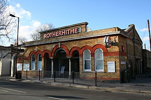
Rotherhithe is a station on the East London Line located on the southern bank of the River Thames at Rotherhithe within the London Borough of Southwark, Greater London and is served by London Overground services. The station is between Wapping and Canada Water, and is in fare zone 2. The station re-opened for a preview service on 27 April 2010 to New Cross / New Cross Gate and 23 May 2010 for full service to New Cross / West Croydon / Crystal Palace.
St Mary's Church, Rotherhithe
Church in London, England
Distance: Approx. 303 meters
Latitude and longitude: 51.50140697,-0.05393947
St Mary's Church, Rotherhithe, is the local Church of England parish church in Rotherhithe, formerly in Surrey and now part of south east London. The parish is now within the diocese of Southwark and under the jurisdiction of the Bishop of Fulham. The 18th-century church is in St Marychurch Street and is dedicated to Mary, mother of Jesus, and it is particularly proud of its connections with the Pilgrim Fathers.

Canada Water
Area in south-east London
Distance: Approx. 461 meters
Latitude and longitude: 51.49703056,-0.04825278
Canada Water is an area of the Docklands in south-east London. It is named after a freshwater lake and wildlife refuge. Canada Water tube, Overground and bus station is immediately north of the lake, along with Canada Water Library which overhangs the lake and Deal Porter Square.

Brunel Museum
Engineering museum in London, England
Distance: Approx. 336 meters
Latitude and longitude: 51.5016,-0.053
The Brunel Museum is a small museum situated at the Brunel Engine House, Rotherhithe, London Borough of Southwark. The Engine House was designed by Sir Marc Isambard Brunel as part of the infrastructure of the Thames Tunnel which opened in 1843 and was the first tunnel to be built under a navigable river anywhere in the world. It comprises the Engine House and the Tunnel Shaft, with rooftop garden.

St Olave's Hospital
Hospital in England
Distance: Approx. 227 meters
Latitude and longitude: 51.49666667,-0.05416667
St Olave's Hospital was a general hospital serving the Rotherhithe area of London until its closure in 1985.

Southwark Park
Park in Rotherhithe, East London
Distance: Approx. 428 meters
Latitude and longitude: 51.495,-0.056
Southwark Park is located in Rotherhithe, in central South East London, England, and is managed by the London Borough of Southwark. It first opened in 1869 by the Metropolitan Board of Works as one of its first parks. It was designed by Alexander McKenzie and covers 63 acres (250,000 m2).

Canada Water bus station
Bus station in London, England
Distance: Approx. 321 meters
Latitude and longitude: 51.4977,-0.05
Canada Water bus station serves the Rotherhithe area of the London Borough of Southwark, London, England. The station is owned and maintained by Transport for London. The bus station was opened on 18 September 1999 at the same time as the Jubilee line extension to Stratford reached Canada Water and is accessible by escalator from Canada Water station below easily.

King's Stairs Gardens
Distance: Approx. 266 meters
Latitude and longitude: 51.50027778,-0.05722222
King's Stairs Gardens is a riverside park in Bermondsey, London. It is bordered to the north by the River Thames and to the south by Jamaica Road (A200), the other side of which is Southwark Park.

King Edward III manor house
Former house in Rotherhithe, London
Distance: Approx. 409 meters
Latitude and longitude: 51.500425,-0.059548
The remains of the so-called King Edward III manor house are near the Thames in Rotherhithe in London.
Poetry School
UK arts organisation (founded 1997)
Distance: Approx. 321 meters
Latitude and longitude: 51.4967,-0.051
Poetry School is a national arts organisation, registered charity and adult education centre providing creative writing tuition, with teaching centres throughout England as well as online courses and downloadable activities. It was founded in 1997 by poets Mimi Khalvati, Jane Duran and Pascale Petit. Poetry School offers an accredited Master's degree in Writing Poetry, delivered in both London and Newcastle, in collaboration with Newcastle University.
Weather in this IP's area
broken clouds
9 Celsius
7 Celsius
7 Celsius
9 Celsius
1013 hPa
89 %
1013 hPa
1012 hPa
10000 meters
3.09 m/s
280 degree
75 %
07:22:17
16:08:29