Country:
Region:
City:
Latitude and Longitude:
Time Zone:
Postal Code:
IP information under different IP Channel
ip-api
Country
Region
City
ASN
Time Zone
ISP
Blacklist
Proxy
Latitude
Longitude
Postal
Route
Luminati
Country
Region
60
City
valletta
ASN
Time Zone
Europe/Malta
ISP
Comvive Servidores S.L.
Latitude
Longitude
Postal
IPinfo
Country
Region
City
ASN
Time Zone
ISP
Blacklist
Proxy
Latitude
Longitude
Postal
Route
db-ip
Country
Region
City
ASN
Time Zone
ISP
Blacklist
Proxy
Latitude
Longitude
Postal
Route
ipdata
Country
Region
City
ASN
Time Zone
ISP
Blacklist
Proxy
Latitude
Longitude
Postal
Route
Popular places and events near this IP address
Lower Barrakka Gardens
Distance: Approx. 260 meters
Latitude and longitude: 35.8975,14.51777778
The Lower Barakka Gardens (Maltese: Il-Barrakka t'Isfel) are a public garden in Valletta, Malta, twinned with the Upper Barrakka Gardens in the same city. The gardens have a view of the Grand Harbour and the breakwater. It includes the Monument to Sir Alexander Ball, which is a prominent feature in the form of a neoclassical temple located in the centre of the garden.
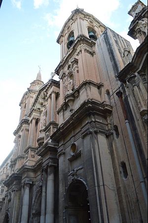
Collegiate Parish Church of St Paul's Shipwreck
Church in Valletta, Malta
Distance: Approx. 285 meters
Latitude and longitude: 35.8974,14.51386
The Collegiate Parish Church of St Paul's Shipwreck, also known as simply the Church of St Paul's Shipwreck, is a Roman Catholic parish church in Valletta, Malta. It is one of Valletta's oldest churches.
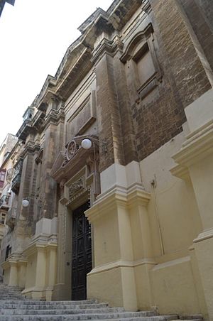
Franciscan Church of St Mary of Jesus
Church in Valletta, Malta
Distance: Approx. 264 meters
Latitude and longitude: 35.89638889,14.51333333
The Franciscan Church of St Mary of Jesus (Convent of the Minori Osservanti) is a church in Valletta, Malta, which is dedicated to St Mary of Jesus and is cared for by the religious order of Friars Minor. It came to be popularly known by the Maltese as Ta' Ġieżu. Ta' Ġieżu is a local corruption of Ta' Ġesù (of Jesus).

Battle of the Malta Convoy
Part of the French Revolutionary Wars, the Siege of Malta (1798–1800)
Distance: Approx. 299 meters
Latitude and longitude: 35.89777778,14.51416667
The Battle of the Malta Convoy was a naval engagement of the French Revolutionary Wars fought on 18 February 1800 during the Siege of Malta. The French garrison at the city of Valletta in Malta had been under siege for eighteen months, blockaded on the landward side by a combined force of British, Portuguese. and irregular Maltese forces and from the sea by a Royal Navy squadron under the overall command of Lord Nelson from his base at Palermo on Sicily.

Church of St Lucy, Valletta
Church in Valletta, Malta
Distance: Approx. 185 meters
Latitude and longitude: 35.89644444,14.51433333
The Church of Saint Lucy is a small Roman Catholic church situated in Valletta, Malta. The church was built in 1570 and features a titular painting above the high altar and the corpse of St Lucian, the martyr.
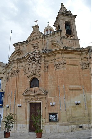
Church of Our Lady of Liesse
Church in Valletta, Malta
Distance: Approx. 254 meters
Latitude and longitude: 35.89508333,14.51336111
The Church of Our Lady of Liesse (Maltese: Knisja tal-Madonna ta' Liesse) is a church in Valletta, Malta. The church was built in 1740 on the site of a 17th-century church. The cupola was built to the design of the Maltese architect Francesco Zammit.
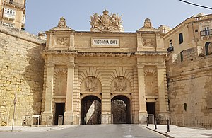
Victoria Gate (Valletta)
City gate in Valletta, Malta
Distance: Approx. 224 meters
Latitude and longitude: 35.896,14.51366667
Victoria Gate (Maltese: Il-Bieb Victoria, Italian: Porta Victoria or Porta Vittoria) is a city gate in Valletta, Malta. It was built by the British in 1885, and was named after Queen Victoria. The gate is the main entrance into the city from the Grand Harbour area, which was once the busiest part of the city.

Carnival tragedy of 1823
Human crush in Valletta, British Malta
Distance: Approx. 264 meters
Latitude and longitude: 35.89638889,14.51333333
The Carnival tragedy of 1823 was a human crush which occurred on 11 February 1823 at the Convent of the Minori Osservanti in Valletta, Malta. About 110 boys who had gone to the convent to receive bread on the last day of carnival celebrations were killed after falling down a flight of steps while trying to get out of the convent.
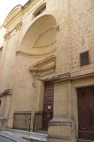
St Roque's Church, Valletta
Church in Valletta, Malta
Distance: Approx. 274 meters
Latitude and longitude: 35.89805556,14.516
The Church of St Roque (Maltese: Knisja ta' San Rokku, Romanian: Biserica Sfântul Rocco) is a 17th-century Baroque church located in Valletta, Malta. The church is the official parish church of the Romanian Orthodox Church in Malta and is subsequently used for Orthodox Divine services. The Romanian Orthodox parish is dedicated to the Birth of John the Baptist.

Monument to Sir Alexander Ball
Monument in the form of a temple in Valletta, Malta
Distance: Approx. 246 meters
Latitude and longitude: 35.89747222,14.51755556
The Monument to Sir Alexander Ball (Maltese: Il-Monument ta' Sir Alexander Ball) is a neoclassical monument in the Lower Barrakka Gardens in Valletta, Malta. It was built in 1810 as a memorial to Sir Alexander Ball, a British admiral who was the first Civil Commissioner of Malta. Attributed to the architect Giorgio Pullicino, the monument is in the form of an ancient Greek temple.

St. Barbara Bastion
Distance: Approx. 173 meters
Latitude and longitude: 35.89638889,14.51444444
Close to the Valletta Grand Harbour, St. Barbara Bastion is a flat-faced bastion with a low parapet overlooking the Grand Harbour Area, Valletta, Malta.

Valletta Contemporary
Contemporary Art Gallery
Distance: Approx. 191 meters
Latitude and longitude: 35.89666667,14.51444444
Valletta Contemporary (VC) is an independent exhibition space in Valletta, Malta. Established in April 2018, the gallery is situated in a 400-year-old former warehouse in East Street, very close to St. Barbara Bastions and Lower Barrakka Gardens.
Weather in this IP's area
few clouds
19 Celsius
19 Celsius
19 Celsius
20 Celsius
1016 hPa
88 %
1016 hPa
1016 hPa
10000 meters
3.6 m/s
250 degree
20 %
06:38:34
16:54:49
