Country:
 Czech Republic
Region:
City:
Latitude and Longitude:
Time Zone:
Postal Code:
IP information under different IP Channel
ip-api
Country
Region
City
ASN
Time Zone
ISP
Blacklist
Proxy
Latitude
Longitude
Postal
Route
IPinfo
Country
Region
City
ASN
Time Zone
ISP
Blacklist
Proxy
Latitude
Longitude
Postal
Route
MaxMind
Country
Region
City
ASN
Time Zone
ISP
Blacklist
Proxy
Latitude
Longitude
Postal
Route
Luminati
Country
CZASN
Time Zone
Europe/Prague
ISP
WIA spol. s.r.o.
Latitude
Longitude
Postal
db-ip
Country
Region
City
ASN
Time Zone
ISP
Blacklist
Proxy
Latitude
Longitude
Postal
Route
ipdata
Country
Region
City
ASN
Time Zone
ISP
Blacklist
Proxy
Latitude
Longitude
Postal
Route
Popular places and events near this IP address

Great Strahov Stadium
Stadium in Prague, Czech Republic
Distance: Approx. 1686 meters
Latitude and longitude: 50.08033611,14.38786111
The Great Strahov Stadium (Czech: Velký strahovský stadion) is a stadium in the Strahov district of Prague, Czech Republic. It was built for displays of synchronized gymnastics on a massive scale, with a field three times as long and three times as wide as the standard association football pitch. Its capacity of 250,000 spectators (56,000 seated) made it larger than any current or former sports stadium, and the second largest sports venue ever.

Stadion Evžena Rošického
Distance: Approx. 1495 meters
Latitude and longitude: 50.08042778,14.3837
Stadion Evžena Rošického, also known simply as Strahov, is a multi-purpose stadium in Strahov, Prague in the Czech Republic. It hosted the 1978 European Athletics Championships and for many years this was the venue for main annual international track and field meet of Prague (Evžen Rošický Memorial and later Josef Odložil Memorial) until Stadion Juliska took the role in 2002. Since then the stadium has used only for minor domestic athletic competitions and mostly for football matches.
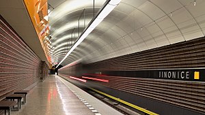
Jinonice (Prague Metro)
Prague metro station
Distance: Approx. 1709 meters
Latitude and longitude: 50.05444444,14.37111111
Jinonice (Czech pronunciation: [ˈjɪnoɲɪtsɛ]) is a Prague Metro station on Line B, located in Jinonice, Prague 5. It was opened on 26 October 1988 as part of the line extension from Smíchovské nádraží to Nové Butovice. General reconstruction took place in 2017.

Bertramka
Distance: Approx. 1729 meters
Latitude and longitude: 50.07030556,14.39508333
Bertramka (Czech: Muzeum W.A. Mozarta a manželů Duškových) is a villa in Prague where Mozart was a frequent guest. Bertramka is now a museum dedicated to the memory of Mozart and to the former owners and Mozart’s hosts: Mr and Mrs Dušek. Bertramka is situated about a mile from the city centre.

Košíře
Distance: Approx. 652 meters
Latitude and longitude: 50.07027778,14.38
Košíře is a district of Prague, part of the municipal area Prague 5. It is situated in the valley of the Motol brook between the districts Smíchov and Motol. Košíře became a town in 1896 and was joined onto Prague in 1921.

Břevnov
District of Prague, Czech Republic
Distance: Approx. 1765 meters
Latitude and longitude: 50.08330556,14.35794444
Břevnov (Czech pronunciation: [ˈbr̝ɛvnof]) is a district in the west of Prague, located in Prague 6. The district is home to the Břevnov Monastery (Czech: Břevnovský klášter). On the territory of Břevnov stems Brusnice brook.
General Inspection of Security Forces
Distance: Approx. 1133 meters
Latitude and longitude: 50.07966944,14.37476667
The General Inspectorate of Security Forces (GIBS) (The Inspectorate General of the Security Forces of the Czech Republic; Czech: Generální inspekce bezpečnostních sborů) is a Czech independent government agency tasked with investigating crimes of the officers of the Police of the Czech Republic, Customs protection, Prison Service, inspection workers or civil employees of these institutions.

National Security Authority (Czech Republic)
Distance: Approx. 1010 meters
Latitude and longitude: 50.06979444,14.38503889
National Security Authority (Czech: Národní bezpečnostní úřad, NBÚ) is a Czech government agency responsible for maintaining security clearances, protection of classified information and cyber security of the Czech Republic. NBÚ is also charged with protection of the Czech government communications and information systems against penetration and network warfare.

Motol (Prague)
Distance: Approx. 1619 meters
Latitude and longitude: 50.0708,14.3483
Motol is a cadastral area of Prague, the capital of the Czech Republic. It is located in the second-tier municipality of Prague 5. It is the location of Motol University Hospital, a large teaching hospital.
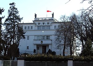
Embassy of Indonesia, Prague
Diplomatic mission
Distance: Approx. 200 meters
Latitude and longitude: 50.070991,14.372992
The Embassy of the Republic of Indonesia in Prague (Indonesian: Kedutaan Besar Republik Indonesia di Praha; Czech: Velvyslanectví Indonéské republiky v Praze) is the diplomatic mission of the Republic of Indonesia to the Czech Republic. The embassy was originally Indonesia's diplomatic mission to Czechoslovakia. After the country's split into the Czech Republic and Slovakia, the embassy became the diplomatic mission for the former.

Ladronka
Activity centre and former squat in Prague, Czech Republic
Distance: Approx. 1423 meters
Latitude and longitude: 50.0785,14.3563
Ladronka is a homestead (usedlost) situated in a park in Břevnov, Prague 6, in the Czech Republic. Built by Charles IV in 1340, it was bought by an Italian count, then owned by the Sovereign Military Order of Malta before being broken into flats during the communist period. It was then squatted in 1993, becoming an internationally famous anarchist, self-managed social centre.

Faculty of Humanities, Charles University
University faculty
Distance: Approx. 1734 meters
Latitude and longitude: 50.054296,14.368604
The Faculty of Humanities, Charles University (Czech: Fakulta humanitních studií Univerzity Karlovy) is a faculty of Charles University in Prague, Czech Republic. Located in Libeň, Prague 8, the faculty has about 220 internal employers and 3250 students. It is a member of the European Colleges of Liberal Arts and Sciences.
Weather in this IP's area
light rain
9 Celsius
6 Celsius
8 Celsius
9 Celsius
1017 hPa
95 %
1017 hPa
987 hPa
8000 meters
4.12 m/s
350 degree
100 %
07:08:56
18:32:31