Country:
 Great Britain
Region:
City:
Latitude and Longitude:
Time Zone:
Postal Code:
IP information under different IP Channel
ip-api
Country
Region
City
ASN
Time Zone
ISP
Blacklist
Proxy
Latitude
Longitude
Postal
Route
IPinfo
Country
Region
City
ASN
Time Zone
ISP
Blacklist
Proxy
Latitude
Longitude
Postal
Route
MaxMind
Country
Region
City
ASN
Time Zone
ISP
Blacklist
Proxy
Latitude
Longitude
Postal
Route
Luminati
Country
GBASN
Time Zone
Europe/London
ISP
CloudCoCo Connect Limited
Latitude
Longitude
Postal
db-ip
Country
Region
City
ASN
Time Zone
ISP
Blacklist
Proxy
Latitude
Longitude
Postal
Route
ipdata
Country
Region
City
ASN
Time Zone
ISP
Blacklist
Proxy
Latitude
Longitude
Postal
Route
Popular places and events near this IP address
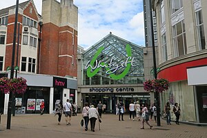
Whitgift Centre
Shopping centre in Croydon, England
Distance: Approx. 453 meters
Latitude and longitude: 51.37583333,-0.10055556
The Whitgift Centre is a large shopping centre in the town centre of Croydon, opening in stages between 1968 and 1970. The centre comprises 1,302,444 sq ft (121,001 m2) of retail space, and was the largest covered shopping development in Greater London until the opening of Westfield London at White City in 2008. The Whitgift Centre has a monthly footfall of 2.08 million.
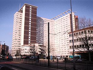
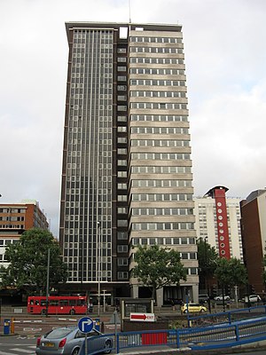
Lunar House
Distance: Approx. 233 meters
Latitude and longitude: 51.37833333,-0.09833333
Lunar House is a 20-storey office block in Croydon, in South London. It is situated at 40 Wellesley Road, on its east side, and houses the headquarters of UK Visas and Immigration, a division of the Home Office in the United Kingdom.
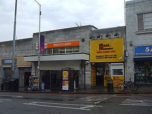
West Croydon station
National rail station and Tramlink tram stop in London
Distance: Approx. 229 meters
Latitude and longitude: 51.37826111,-0.10254444
West Croydon is a combined railway, bus station and tram stop in Croydon, south London. It is served by National Rail, London Overground, Tramlink and London Buses services and is in Travelcard Zone 5. The East London line, part of London Overground, was extended to the station in 2010.
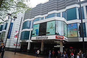
Centrale (Croydon)
Shopping centre in Greater London, England
Distance: Approx. 466 meters
Latitude and longitude: 51.376,-0.103
Centrale is a shopping centre in Croydon, South London, one of the largest covered retail developments in London. It is owned and managed by Unibail-Rodamco-Westfield and was opened in 2004. Plans were announced in January 2013 to redevelop Centrale and combine it with the Whitgift Centre.

Centrale tram stop
Tramlink tram stop in London, England
Distance: Approx. 512 meters
Latitude and longitude: 51.3758,-0.1039
Centrale tram stop is a stop on the Tramlink service in Croydon town centre, serving the Centrale shopping centre. The tram stop was provided and paid for as part of the development of the shopping centre. The stop operates as a transport interchange with trams stopping on one side of the platform and local buses on the other.

North End, Croydon
Distance: Approx. 481 meters
Latitude and longitude: 51.3756,-0.1013
North End is a pedestrianised road in Central Croydon, which includes entrances to the town's two main shopping centres, Centrale and the Whitgift Centre. The road has high street chains including Next, Zara, French Connection, and a large branch of department store House of Fraser. A large Debenhams store on the west side of the road did not reopen after the 2020 Coronavirus lockdown as the company entered administration.
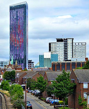
Saffron Square
A town square and tower block in Croydon
Distance: Approx. 176 meters
Latitude and longitude: 51.37888889,-0.09861111
Saffron Square (formerly known as Wellesley Square) is a town square and high-rise building in Croydon, United Kingdom. The purple and red Saffron Tower is currently the second-tallest building in Croydon. Saffron Square is part of the Croydon Vision 2020 regeneration plan for the London Borough of Croydon to add to its goal of being London's Third City.

The Island, Croydon
High-rise residential building in London, England
Distance: Approx. 310 meters
Latitude and longitude: 51.3823,-0.0983
The Island (also known as Newgate Tower, and previously ISLAND and IYLO) is a residential skyscraper in the London Borough of Croydon, London. In 2018, the building's 17th-floor penthouse apartment was described as the "most expensive flat in Croydon". The building was designed to have 20 floors of apartments and a roof height of 61 metres (200 ft).

St Mary's Roman Catholic High School, Croydon
Voluntary aided school in Croydon, Greater London, England
Distance: Approx. 212 meters
Latitude and longitude: 51.38014,-0.09754
St. Mary's Roman Catholic High School is a co-educational, 11-19 secondary school in Croydon, England.
Croydon Co-operative Society
Distance: Approx. 367 meters
Latitude and longitude: 51.3809,-0.1056
The Croydon Co-operative Society was a cooperative retailer in Croydon and surrounding parts of Surrey, England. In 1918, it became part of the new South Suburban Co-operative Society, now the Co-operative Group. A co-operative society had been formed in Croydon in 1860, the Croydon Co-operative Industrial Society, with headquarters in Market Street and later at 39 Church Street.
Apollo House (Croydon)
Distance: Approx. 352 meters
Latitude and longitude: 51.3771,-0.0982
Apollo House is a 22-storey high-rise office building at 36 Wellesley Road in the London Borough of Croydon, London, England. In common with a neighbouring building Lunar House and others developed by Harry Hyams, the building's name was inspired by the Apollo 11 Moon landing in 1969. Like Lunar House, Apollo serves as the headquarters of UK Visas and Immigration, a division of the Home Office in the United Kingdom.
Harris Invictus Academy Croydon
Free school in Croydon, Greater London, England
Distance: Approx. 269 meters
Latitude and longitude: 51.380098,-0.104425
Harris Invictus Academy Croydon is an 11–18 mixed, free secondary school and sixth form in Croydon, Greater London, England. It was established in September 2014 and is part of the Harris Federation.
Weather in this IP's area
scattered clouds
13 Celsius
12 Celsius
11 Celsius
14 Celsius
1027 hPa
88 %
1027 hPa
1020 hPa
10000 meters
2.57 m/s
360 degree
40 %
06:37:31
19:13:00