Country:
Region:
City:
Latitude and Longitude:
Time Zone:
Postal Code:
IP information under different IP Channel
ip-api
Country
Region
City
ASN
Time Zone
ISP
Blacklist
Proxy
Latitude
Longitude
Postal
Route
Luminati
Country
Region
51
City
sanpawlilbahar
ASN
Time Zone
Europe/Malta
ISP
Melita Limited
Latitude
Longitude
Postal
IPinfo
Country
Region
City
ASN
Time Zone
ISP
Blacklist
Proxy
Latitude
Longitude
Postal
Route
db-ip
Country
Region
City
ASN
Time Zone
ISP
Blacklist
Proxy
Latitude
Longitude
Postal
Route
ipdata
Country
Region
City
ASN
Time Zone
ISP
Blacklist
Proxy
Latitude
Longitude
Postal
Route
Popular places and events near this IP address

Swieqi
Local council in Northern Region, Malta
Distance: Approx. 1304 meters
Latitude and longitude: 35.92083333,14.48
Swieqi (Maltese: Is-Swieqi) is a town in the Northern Region of Malta. It is a residential area just 15 minutes by bus from Sliema and within walking distance of Malta's nightlife and entertainment centres, Paceville and St. Julian's.

San Ġwann
Local council in Northern Region, Malta
Distance: Approx. 347 meters
Latitude and longitude: 35.90944444,14.47861111
San Ġwann (English: Saint John) is a town in the Northern Region of Malta, with a population of 14,244 as of 2021. Prior to its establishment as a distinct municipality, it was a fragmented community comprising parts of Birkirkara and St. Julian's.

University of Malta
Public university in Malta
Distance: Approx. 1167 meters
Latitude and longitude: 35.90222222,14.48361111
The University of Malta (Maltese: L-Università ta' Malta, UM, formerly UOM) is a higher education institution in Malta. It offers undergraduate bachelor's degrees, postgraduate master's degrees and postgraduate doctorates. It is a member of the European University Association, the European Access Network, Association of Commonwealth Universities, the Utrecht Network, the Santander Network, the Compostela Group, the European Association for University Lifelong Learning (EUCEN) and the International Student Exchange Programme (ISEP).
Flarestar Observatory
Observatory
Distance: Approx. 385 meters
Latitude and longitude: 35.9111,14.4708
Flarestar Observatory (obs. code: 171) is an astronomical observatory owned and operated and managed by astronomer and AAVSO-member Stephen M. Brincat. It is located near San Ġwann on the island country of Malta.

Madliena
Distance: Approx. 1304 meters
Latitude and longitude: 35.92083333,14.48
Madliena (Maltese: Il-Madliena), formerly spelt Madalena, is an area in Swieqi, in Northern Region, Malta, formerly part of the adjacent town of Għargħur.

Mater Dei Hospital
Hospital in Central Region, Malta
Distance: Approx. 916 meters
Latitude and longitude: 35.90182778,14.47674444
Mater Dei Hospital (MDH; Maltese: Sptar Mater Dei), also known simply as Mater Dei, is an acute general and teaching hospital in Msida, Malta. It was opened in 2007, replacing St. Luke's Hospital.
Chiswick House School
Distance: Approx. 861 meters
Latitude and longitude: 35.9071,14.4837
Chiswick House School forms part of a co-educational establishment in Malta, catering to students between two and eighteen years of age. Chiswick is also proposing to build a new school on virgin land in Pembroke, Malta.

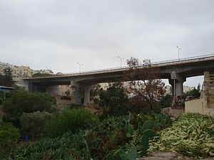
Manwel Dimech Bridge
Bridge in San Ġiljan, Malta
Distance: Approx. 1240 meters
Latitude and longitude: 35.91611111,14.48622222
Manwel Dimech Bridge is a beam bridge at St. Julian's, Malta. It is named after Manuel Dimech and was officially inaugurated on 18 September 1971 by the Minister of Public Works, Lorry Sant.

Santa Margerita Chapel
Distance: Approx. 199 meters
Latitude and longitude: 35.91,14.477
Santa Margerita Chapel (English: Saint Margaret Chapel), also known as Arar Chapel, is a 16th century chapel in San Gwann, Malta. The chapel was built for the farmers working the surrounding fields. At the time, attacks from the sea were common.

Ta' Ċieda Tower
Ancient tower in San Ġwann, Malta
Distance: Approx. 540 meters
Latitude and longitude: 35.9075,14.48
Ta' Ċieda Tower, also known as San Ġwann Roman Tower, is a Punic-Roman tower in San Ġwann, Malta. The exact origins of the tower could date back to pre-history with different architecture. It is argued that the tower could be of Punic origins rather than Roman but the latter have adapted it.

Sanctuary of Our Lady of Tal-Ħerba
Church in Birkirkara, Malta
Distance: Approx. 1316 meters
Latitude and longitude: 35.90122222,14.46488889
The Sanctuary of Our Lady of Tal-Ħerba (Maltese: Santwarju tal-Madonna tal-Ħerba) is a Roman Catholic church in Birkirkara, Malta, dedicated to the Nativity of Mary. It was constructed at various stages between the early 17th century and the 1920s, on the site of an earlier church which had existed since at least 1575. Pope Pius X granted a Pontifical decree of coronation to the venerated Marian image on 13 February 1910 signed via Cardinal Mariano Rampolla y Tindaro, and notarized by Cardinal Angelo di Pietro.

Eastern Region, Malta
Region of Malta
Distance: Approx. 520 meters
Latitude and longitude: 35.91183333,14.48005556
The Eastern Region (Maltese: Reġjun Lvant) is one of the six regions of Malta. The region is located in the northeastern part of the main island of Malta. The region borders the Northern, Port and Southern Regions.
Weather in this IP's area
few clouds
18 Celsius
18 Celsius
18 Celsius
19 Celsius
1024 hPa
82 %
1024 hPa
1013 hPa
10000 meters
3.09 m/s
260 degree
20 %
06:27:37
17:03:41