Country:
 Malta
MaltaRegion:
City:
Latitude and Longitude:
Time Zone:
Postal Code:
IP information under different IP Channel
ip-api
Country
Region
City
ASN
Time Zone
ISP
Blacklist
Proxy
Latitude
Longitude
Postal
Route
IPinfo
Country
Region
City
ASN
Time Zone
ISP
Blacklist
Proxy
Latitude
Longitude
Postal
Route
MaxMind
Country
Region
City
ASN
Time Zone
ISP
Blacklist
Proxy
Latitude
Longitude
Postal
Route
Luminati
Country
MTRegion
32
City
mosta
ASN
Time Zone
Europe/Malta
ISP
Melita Limited
Latitude
Longitude
Postal
db-ip
Country
Region
City
ASN
Time Zone
ISP
Blacklist
Proxy
Latitude
Longitude
Postal
Route
ipdata
Country
Region
City
ASN
Time Zone
ISP
Blacklist
Proxy
Latitude
Longitude
Postal
Route
Popular places and events near this IP address
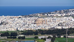
Mosta
Local council in Northern Region, Malta
Distance: Approx. 504 meters
Latitude and longitude: 35.90972222,14.42611111
Mosta (Maltese: Il-Mosta) is a small but densely populated city in the Northern Region of Malta. The most prominent building in Mosta is the Rotunda, a large basilica built by its parishioners' volunteer labour. It features the world's 3rd largest unsupported dome, and displays a replica of a German bombshell that famously crashed through the dome but did not detonate upon impact.

National Stadium, Ta' Qali
Football stadium
Distance: Approx. 2321 meters
Latitude and longitude: 35.895,14.41527778
The National Stadium, locally also referred to as Ta' Qali, officially known as Grawnd Nazzjonali (Maltese for National Stadium), is a stadium located in Ta' Qali, Malta. The stadium, which also contains the headquarters of the Malta Football Association, seats 16,997 people and is, by far, the largest stadium in the country. It serves as the national football stadium of Malta and is the home stadium of the Malta national football team.

Rotunda of Mosta
Church in Mosta, Malta
Distance: Approx. 461 meters
Latitude and longitude: 35.91008333,14.42588889
The Sanctuary Basilica of the Assumption of Our Lady (Maltese: Santwarju Bażilika ta' Santa Marija), commonly known as the Rotunda of Mosta (Maltese: Ir-Rotunda tal-Mosta) or the Mosta Dome, is a Roman Catholic parish church and basilica in Mosta, Malta, dedicated to the Assumption of Mary. It was built between 1833 and the 1860s to neoclassical designs of Giorgio Grognet de Vassé, on the site of an earlier Renaissance church which had been built around 1614 to designs of Tommaso Dingli. The design of the present church is based on the Pantheon in Rome, has the third-largest unsupported dome in the world, and is Malta's largest and most famous church.

Naxxar
Local council in Northern Region, Malta
Distance: Approx. 1753 meters
Latitude and longitude: 35.915,14.44472222
Naxxar (Maltese: In-Naxxar) is a town and local council in the Northern Region of Malta. The population in March 2014 was 14,891. The Naxxar Church is dedicated to Our Lady of Victories.

Wied il-Għasel
Valley in Mosta, Malta
Distance: Approx. 503 meters
Latitude and longitude: 35.918461,14.427141
Wied il-Għasel (English: Honey Valley) is a valley in Mosta, in the Northern Region of Malta. Several caves are located within the valley, one of which is occupied by the small Chapel of St. Paul the Hermit.

Centenary Stadium
Maltese football ground
Distance: Approx. 2140 meters
Latitude and longitude: 35.89666667,14.41555556
The Centenary Stadium (Maltese: il-Grawnd taċ-Ċentinarju) is a stadium located in Ta' Qali, Malta. The stadium, which is situated next to the National Stadium, houses the headquarters of the Malta Youth Football Association. It seats 3,000 and serves as the home stadium of the Malta national under-21 football team.

Charles Abela Memorial Stadium
Distance: Approx. 1355 meters
Latitude and longitude: 35.90472222,14.43472222
The Charles Abela Memorial Stadium, also known as the Mosta Ground is a ground situated in Mosta, Malta. It has a total capacity of 700 with 360 seats. The stadium hosts matches from various competitions, most notably the Maltese Third Division and the Women Maltese First Division.

Gauci Tower
Tower in Malta
Distance: Approx. 1676 meters
Latitude and longitude: 35.91987,14.44252
Gauci Tower (Maltese: Torri Gauci, Italian: Torre Gauci) is a tower in Naxxar, Malta. It was built before 1548 by the Gauci family. The tower remains in good condition.
Church of the Nativity of Mary, Naxxar
Church in Naxxar, Malta
Distance: Approx. 1759 meters
Latitude and longitude: 35.9148,14.4448
The Church of the Nativity of Mary is a Roman Catholic baroque parish church located in Naxxar, Malta.

Villa Francia
Palace in Lija, Malta
Distance: Approx. 2159 meters
Latitude and longitude: 35.90313,14.44496
Villa Francia, initially named Palazzo Francia, then named Villa Preziosi, and officially known as Palazzo Francia and Francia Estate, is an 18th-century palace in Lija, Malta. The palace was built circa 1757, by Francesco Preziosi, with baroque architecture that gave a sense of pride and power to noble people at the time. The first ambitious owner became bankrupt with the expenses of the palace, to make it an outstanding and incomparable building, and because of this he was pressured to sell his possession by the Order of St.

RAF Ta Kali
Distance: Approx. 2175 meters
Latitude and longitude: 35.895,14.42083333
Royal Air Force Ta Kali was a Royal Air Force fighter operations base located on the island of Malta, which started life in 1940 as a diversion airstrip for the main operating bases such as RAF Luqa. Other diversion airstrips similar in function to Ta Kali were located at RAF Hal Far and on Malta's second island of Gozo at Xewkija airfield. The base's name reflects an anglicised corruption of the correct Maltese spelling of Ta' Qali, other phonetic variants of the correct name also appear regularly.
Malta Fairs & Conventions Centre
Multi-purpose venue in Attard, Malta
Distance: Approx. 2181 meters
Latitude and longitude: 35.89566667,14.41747222
The Malta Fairs & Conventions Centre (also known as MFCC) is a multi-purpose venue located in Ta' Qali, Attard, Malta. The centre can be used for concerts, exhibitions, trade fairs, examinations, conferences, galas and weddings. After its expansion in 2018, the venue measures 170m x 50m, totalling 8,500 m2.
Weather in this IP's area
few clouds
19 Celsius
19 Celsius
19 Celsius
20 Celsius
1014 hPa
82 %
1014 hPa
1006 hPa
10000 meters
3.09 m/s
150 degree
20 %
07:12:33
18:21:32