Country:
 Great Britain
Region:
City:
Latitude and Longitude:
Time Zone:
Postal Code:
IP information under different IP Channel
ip-api
Country
Region
City
ASN
Time Zone
ISP
Blacklist
Proxy
Latitude
Longitude
Postal
Route
IPinfo
Country
Region
City
ASN
Time Zone
ISP
Blacklist
Proxy
Latitude
Longitude
Postal
Route
MaxMind
Country
Region
City
ASN
Time Zone
ISP
Blacklist
Proxy
Latitude
Longitude
Postal
Route
Luminati
Country
GBRegion
eng
City
wandsworth
ASN
Time Zone
Europe/London
ISP
Daisy Corporate Services Trading Ltd
Latitude
Longitude
Postal
db-ip
Country
Region
City
ASN
Time Zone
ISP
Blacklist
Proxy
Latitude
Longitude
Postal
Route
ipdata
Country
Region
City
ASN
Time Zone
ISP
Blacklist
Proxy
Latitude
Longitude
Postal
Route
Popular places and events near this IP address

Brondesbury
Human settlement in England
Distance: Approx. 650 meters
Latitude and longitude: 51.54567,-0.20597
Brondesbury (), which includes Brondesbury Park, is an area in the London Borough of Brent, in London, England. The area is traditionally part of the Ancient Parish and subsequent Municipal Borough of Willesden, one of the areas that merged to form the modern borough of Brent. Brondesbury railway station lies 4.1 miles north-west of Charing Cross, and its proximity to the originally Roman A5 road (the borough's eastern boundary) sometimes leads to addresses on the eastern, Camden, side of the road to also be informally described as part of Brondesbury.

Brondesbury railway station
London Overground station
Distance: Approx. 387 meters
Latitude and longitude: 51.5451,-0.202
Brondesbury is on the North London line, on a viaduct crossing Kilburn High Road in the Brondesbury area of Kilburn in the London Borough of Brent in north-west London. It is approximately 200 metres south-east of Kilburn station and half a mile north-west of Kilburn High Road station. Ticket barriers are now in operation.
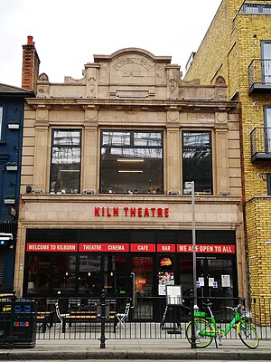
Kiln Theatre
Theatre in Kilburn, London, England
Distance: Approx. 162 meters
Latitude and longitude: 51.5433,-0.2
The Kiln Theatre (formerly the Tricycle Theatre) is a theatre located in Kilburn, in the London Borough of Brent, England. Since 1980, the theatre has presented a wide range of plays reflecting the cultural diversity of the area, as well as new writing, political work and verbatim reconstructions of public inquiries. The theatre has produced original work by playwrights such as Lynn Nottage, Patrick Barlow, Richard Bean, David Edgar, Stephen Jeffreys, Abi Morgan, Simon Stephens, Roy Williams, Lolita Chakrabarti, Moira Buffini, Alexi Kaye Campbell, Florian Zeller, Ayad Akhtar and Zadie Smith.

Kilburn Grange Park
Distance: Approx. 123 meters
Latitude and longitude: 51.54388889,-0.1975
Kilburn Grange Park is a 3.2 hectares (7.9 acres) open space in Kilburn, north-west London adjacent to Kilburn High Road. It is administered by the London Borough of Camden and includes a children's playground, basketball court, outdoor gym equipment and tennis courts. The park first opened in 1913 having previously been part of the Grange estate.
Decca Studios
Former recording studio in West Hampstead, London
Distance: Approx. 644 meters
Latitude and longitude: 51.5463,-0.1904
Decca Studios was a recording facility at 165 Broadhurst Gardens, West Hampstead, North London, England, controlled by Decca Records from 1937 to 1980.

Gaumont State Cinema
Theatre in Kilburn, London, England
Distance: Approx. 168 meters
Latitude and longitude: 51.5413,-0.19757
Gaumont State Cinema is a Grade II* listed Art Deco theatre located in Kilburn, a district in northwest London.

West End Lane
Street in London, England
Distance: Approx. 547 meters
Latitude and longitude: 51.54566,-0.19137
West End Lane is a street in inner north-west London, England (grid reference TQ2585) that runs for about one mile between Kilburn High Road to the south and Finchley Road to the north. Located in the London Borough of Camden, and the NW6 postal district, the street winds through West Hampstead with a mix of residential and commercial buildings. The three West Hampstead stations are all located on the road at the centre of the district of that name.

Cock Tavern Theatre
Pub theatre in London, England
Distance: Approx. 423 meters
Latitude and longitude: 51.539342,-0.195271
The Cock Tavern Theatre was a pub theatre located in Kilburn in the north-west of London. The venue specialised in new works and critical revivals. Resident companies Good Night Out Presents and OperaUpClose were also based at the venue.

Kilburn Priory
Historic monastic community Northwest of London
Distance: Approx. 602 meters
Latitude and longitude: 51.541,-0.1896
Kilburn Priory was a small monastic community of nuns established around 1130–1134 three miles north-west of the City of London, where Watling Street (now Kilburn High Road) met the stream now known as the Westbourne, but variously known as Cuneburna, Keneburna, Keeleburne, Coldburne, or Caleburn, meaning either the royal or cow's stream. The priory gave its name to the area now known as Kilburn, and the local streets Priory Road, Kilburn Priory, Priory Terrace, and Abbey Road. Kilburn Lane connected the priory to the village of Kensal to the west.
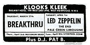
Klooks Kleek
London music venue of the 1960s
Distance: Approx. 611 meters
Latitude and longitude: 51.5463,-0.191
Klooks Kleek was a jazz and rhythm 'n’ blues club on the first floor of the Railway Hotel, West Hampstead, north-west London. Named after "Klook's Clique", a 1956 album by jazz drummer Kenny Clarke (Savoy Records 12006), the club opened on 11 January 1961 with special guest Don Rendell (tenor sax) and closed nine years later on 28 January 1970 after a session by drummer Keef Hartley’s group. There were over 1200 sessions at Klook’s Kleek, around 300 of them featuring jazz, and the others rhythm ‘n’ blues.

Black Lion, Kilburn
Pub in Kilburn, London
Distance: Approx. 181 meters
Latitude and longitude: 51.543796,-0.199868
The Black Lion is a Grade II* listed public house at 274 Kilburn High Road, Kilburn, London. It is on the Campaign for Real Ale's National Inventory of Historic Pub Interiors. It was built in about 1898 by the architect R. A. Lewcock (1846–1932), with the interior carved panels by Frederick T Callcott.

Biddy Mulligan's pub bombing
1975 bombing carried out by the UDA in London
Distance: Approx. 107 meters
Latitude and longitude: 51.54184722,-0.19804444
The Biddy Mulligan's pub bombing occurred on the night of Saturday 20 December 1975 with the explosion of a 3 to 5 lb bomb at Biddy Mulligan's, an Irish pub on the corner of Kilburn High Road and Willesden Lane in northwest London. The device, left in a holdall, caused five injuries and damaged the premises. The Ulster Defence Association (UDA) under the cover name Ulster Freedom Fighters (UFF) claimed responsibility, saying it was targeted because it was frequented by Irish republican sympathisers, with allegedly funds being raised for the Provisional Irish Republican Army (IRA).
Weather in this IP's area
few clouds
25 Celsius
25 Celsius
23 Celsius
26 Celsius
1023 hPa
53 %
1023 hPa
1018 hPa
10000 meters
7.2 m/s
60 degree
20 %
06:42:34
19:06:30