Country:
Region:
City:
Latitude and Longitude:
Time Zone:
Postal Code:
IP information under different IP Channel
ip-api
Country
Region
City
ASN
Time Zone
ISP
Blacklist
Proxy
Latitude
Longitude
Postal
Route
Luminati
Country
Region
eng
City
ilford
ASN
Time Zone
Europe/London
ISP
Daisy Corporate Services Trading Ltd
Latitude
Longitude
Postal
IPinfo
Country
Region
City
ASN
Time Zone
ISP
Blacklist
Proxy
Latitude
Longitude
Postal
Route
db-ip
Country
Region
City
ASN
Time Zone
ISP
Blacklist
Proxy
Latitude
Longitude
Postal
Route
ipdata
Country
Region
City
ASN
Time Zone
ISP
Blacklist
Proxy
Latitude
Longitude
Postal
Route
Popular places and events near this IP address

Coleraine
Town in County Londonderry, Northern Ireland
Distance: Approx. 362 meters
Latitude and longitude: 55.133,-6.661
Coleraine ( kohl-RAYN; from Irish: Cúil Raithin [ˌkuːlʲ ˈɾˠahənʲ], 'nook of the ferns') is a town and civil parish near the mouth of the River Bann in County Londonderry, Northern Ireland. It is 55 miles (89 km) north-west of Belfast and 30 miles (48 km) east of Derry, both of which are linked by major roads and railway connections. It is part of Causeway Coast and Glens district.

County Coleraine
Defunct administrative area in Ireland
Distance: Approx. 168 meters
Latitude and longitude: 55.132,-6.668
County Coleraine, called the County of Colerain in the earliest documents, was one of the counties of Ireland from 1585 to 1613. It was named after its intended county town, Coleraine. It was later subsumed into County Londonderry along with a big part of the once larger County Tyrone and small territories from County Donegal and County Antrim.

Coleraine Borough Council
Human settlement in Northern Ireland
Distance: Approx. 168 meters
Latitude and longitude: 55.132,-6.668
Coleraine Borough Council was a local council mainly in County Londonderry and partly in County Antrim in Northern Ireland. It merged with Ballymoney Borough Council, Limavady Borough Council and Moyle District Council in May 2015 under local government reorganisation in Northern Ireland to become Causeway Coast and Glens District Council. Its headquarters were in the town of Coleraine.
Causeway Institute
Distance: Approx. 194 meters
Latitude and longitude: 55.135,-6.666
The Causeway Institute of Further and Higher Education (informally Causeway Institute or CIFHE) was a third-level educational institution in Northern Ireland, United Kingdom. The Causeway Institute was located on two campuses: Coleraine, County Londonderry and Ballymoney, County Antrim.

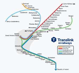
Coleraine railway station
Station in County Londonderry, Northern Ireland
Distance: Approx. 245 meters
Latitude and longitude: 55.133856,-6.662937
Coleraine railway station serves the town of Coleraine in County Londonderry, Northern Ireland. It shares facilities with the town's Ulsterbus bus depot.

The Showgrounds (Coleraine)
Irish football (futbol) stadium
Distance: Approx. 411 meters
Latitude and longitude: 55.13277778,-6.66027778
The Showgrounds is a football stadium in Coleraine, County Londonderry, Northern Ireland. It is the home ground of Coleraine F.C. The stadium holds approximately 3,500 with the stadium consisting of a mix of terracing and seating. Between September 1971 and October 1972, Derry City F.C. were forced to use the stadium as their home-ground after the Irish Football Association banned the use of their ground in Derry, the Brandywell, due to security fears emanating from the Trouble and civil unrest in the nearby Bogside area.
Coleraine High School
Grammar school in Northern Ireland
Distance: Approx. 473 meters
Latitude and longitude: 55.13,-6.662
Coleraine High School was an all-girls' grammar school located in Coleraine, County Londonderry, Northern Ireland. The High School, or Gordonville Ladies' Academy as it was originally known, was founded in 1875 in Alexander Terrace, Coleraine, by Mrs Long, assisted by her daughter and staff. From 1924 until 1959, the school, as a voluntary grammar school, was controlled by a board of governors.
Coleraine (Parliament of Ireland constituency)
Pre-1801 Irish constituency
Distance: Approx. 168 meters
Latitude and longitude: 55.132,-6.668
Coleraine was a constituency represented in the Irish House of Commons from 1611 to 1800. Between 1725 and 1793 Catholics and those married to Catholics could not vote.
Coleraine Castle
Former castle in County Londonderry, Northern Ireland
Distance: Approx. 663 meters
Latitude and longitude: 55.1325,-6.677
Coleraine Castle was a castle situated at Coleraine, County Londonderry, Northern Ireland. The Annals of Ulster reports that the Earl of Atholl, Thomas fitz Roland, built the castle in 1214. It was later destroyed by Hugh de Lacy and the King of Tír Eoghain, Aodh Méith Ó Néill, as evidenced by the same source in 1223.
1973 Coleraine bombings
1973 IRA attack in Northern Ireland
Distance: Approx. 111 meters
Latitude and longitude: 55.133,-6.665
The 1973 Coleraine bombings took place on 12 June 1973 the Provisional IRA detonated two car bombs in Coleraine, County Londonderry, Northern Ireland. The first bomb exploded at 3:00 pm on Railway Road, killing six people and injuring 33; several lost limbs and were left disabled for life. A second bomb exploded five minutes later at Hanover Place.

County Hall, Coleraine
County building in Coleraine, Northern Ireland
Distance: Approx. 672 meters
Latitude and longitude: 55.135,-6.6768
County Hall is a municipal facility in Coleraine, County Londonderry, Northern Ireland. It served as the headquarters of Londonderry County Council from 1960 to 1973.

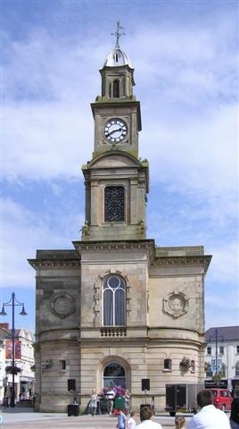
Coleraine Town Hall
Municipal building in Coleraine, Northern Ireland
Distance: Approx. 345 meters
Latitude and longitude: 55.1316,-6.6712
Coleraine Town Hall is a municipal structure in The Diamond in Coleraine, County Londonderry, Northern Ireland. The town hall, which was the headquarters of Coleraine Borough Council, is a Grade B1 listed building.
Weather in this IP's area
overcast clouds
11 Celsius
10 Celsius
11 Celsius
12 Celsius
1021 hPa
78 %
1021 hPa
1020 hPa
10000 meters
5.34 m/s
8.59 m/s
147 degree
100 %
07:47:51
16:33:17