Country:
Region:
City:
Latitude and Longitude:
Time Zone:
Postal Code:
IP information under different IP Channel
ip-api
Country
Region
City
ASN
Time Zone
ISP
Blacklist
Proxy
Latitude
Longitude
Postal
Route
Luminati
Country
Region
eng
City
westdrayton
ASN
Time Zone
Europe/London
ISP
Daisy Corporate Services Trading Ltd
Latitude
Longitude
Postal
IPinfo
Country
Region
City
ASN
Time Zone
ISP
Blacklist
Proxy
Latitude
Longitude
Postal
Route
db-ip
Country
Region
City
ASN
Time Zone
ISP
Blacklist
Proxy
Latitude
Longitude
Postal
Route
ipdata
Country
Region
City
ASN
Time Zone
ISP
Blacklist
Proxy
Latitude
Longitude
Postal
Route
Popular places and events near this IP address

Bisham Abbey
Listed manor house at Bisham in the English county of Berkshire
Distance: Approx. 210 meters
Latitude and longitude: 51.556635,-0.779657
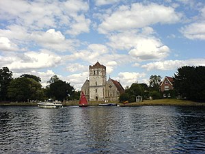
Bisham Abbey is a Grade I listed manor house at Bisham in the English county of Berkshire. The name is taken from the now lost monastery which once stood alongside. This original Bisham Abbey was previously named Bisham Priory, and was the traditional resting place of many Earls of Salisbury.

Marlow Bridge
Bridge in Marlow
Distance: Approx. 1058 meters
Latitude and longitude: 51.567,-0.773
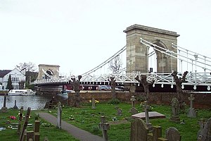
Marlow Bridge is a road traffic and foot bridge over the River Thames in England between the town of Marlow, Buckinghamshire and the village of Bisham in Berkshire. It crosses the Thames just upstream of Marlow Lock, on the reach to Temple Lock. The bridge is a Grade I listed building.
Bisham
Village and civil parish in England
Distance: Approx. 166 meters
Latitude and longitude: 51.558,-0.775
Bisham is a village and civil parish in the Royal Borough of Windsor and Maidenhead in Berkshire, England. The village is on the River Thames, around one mile (1.6 km) south of Marlow in the neighbouring county of Buckinghamshire, and around three miles (5 km) northwest of Maidenhead. At the 2011 Census, the population of the parish was 1,099, down from 1,149 at the 2001 Census.
Temple Lock
Lock and weir on the River Thames in Buckinghamshire, England
Distance: Approx. 1316 meters
Latitude and longitude: 51.5521,-0.793965
Temple Lock is a lock and weir situated on the Buckinghamshire bank of the River Thames near Temple Mill Island opposite Temple Meadows and not far from Hurley, Berkshire. It was first built by the Thames Navigation Commissioners in 1773. The weir runs across from the lock to the Berkshire bank a short distance upstream of the lock.
Marlow Lock
Lock and weir on the River Thames in Buckinghamshire, England
Distance: Approx. 1203 meters
Latitude and longitude: 51.5673,-0.768812
Marlow Lock is a lock and weir situated on the River Thames in the town of Marlow, Buckinghamshire, England, about 300m downstream of Marlow Bridge. The first pound lock was built by the Thames Navigation Commission in 1773. The weir stretches a long way upstream above the lock.
Temple Mill Island
Island in the River Thames
Distance: Approx. 1008 meters
Latitude and longitude: 51.5526,-0.7892
Temple Mill Island is an island in the River Thames in England upstream of Marlow, and just downstream of Temple Lock. It is on the southern Berkshire bank close to Hurley. The island is named after the three watermills that used to be on the island for beating copper and brass.

Bisham Woods
Distance: Approx. 750 meters
Latitude and longitude: 51.5574,-0.7666
Bisham Woods is an 86-hectare (210-acre) biological Site of Special Scientific Interest (SSSI) west of Cookham in Berkshire. The site is also a Local Nature Reserve and part of Chilterns Beechwoods Special Area of Conservation. The SSSI is part of a 153.2-hectare (379-acre) site, also called Bisham Woods, which has been owned and managed by the Woodland Trust since 1990.
Marlow Rowing Club
Distance: Approx. 1031 meters
Latitude and longitude: 51.56680556,-0.77333333
Marlow Rowing Club is a rowing club on the River Thames in England, on the southern bank of the Thames at Bisham in Berkshire, opposite the town of Marlow, Buckinghamshire just beside Marlow Bridge and on the reach above Marlow Lock. Founded in 1871, it is one of the main rowing and sculling centres in England. Members of the club have represented Great Britain in the Olympic Games and World Championships.

Marlow Urban District
Distance: Approx. 1226 meters
Latitude and longitude: 51.566667,-0.766667
Marlow Urban District was a local government authority in the administrative county of Buckinghamshire, England, between 1896 and 1974, covering the town of Marlow.

Pound Lane Cricket Ground
Cricket ground in Marlow, Buckinghamshire
Distance: Approx. 1044 meters
Latitude and longitude: 51.56704,-0.78075
Pound Lane is a cricket ground in Marlow, Buckinghamshire. The first recorded match on the ground was in 1909, when Buckinghamshire played Dorset in the Minor Counties Championship. The county next used the ground for a Minor Counties match in 1913, when it played Berkshire.

Bradnam Wood
Nature reserve in Berkshire, United Kingdom
Distance: Approx. 1007 meters
Latitude and longitude: 51.549,-0.78
Bradnam Wood is a 12.5-hectare (31-acre) Local Nature Reserve west of Maidenhead in Berkshire. It is owned by the Royal Borough of Windsor and Maidenhead and managed by The Woodland Trust. This site has mature woodland at the northern end and more recently planted trees in the south.

Court Garden, Marlow
Building in Buckinghamshire, England
Distance: Approx. 1086 meters
Latitude and longitude: 51.56765,-0.77707
Court Garden in Marlow, Buckinghamshire, England, is a Grade II* listed building on the National Heritage List for England. It was built as a house in about 1758 by Dr William Battie, an eminent physician. It was sold in 1776 to Richard Davenport and remained in the Davenport family until 1894.
Weather in this IP's area
overcast clouds
8 Celsius
7 Celsius
7 Celsius
9 Celsius
1024 hPa
78 %
1024 hPa
1020 hPa
10000 meters
1.96 m/s
2.62 m/s
317 degree
100 %
07:11:29
16:22:32


