Country:
Region:
City:
Latitude and Longitude:
Time Zone:
Postal Code:
IP information under different IP Channel
ip-api
Country
Region
City
ASN
Time Zone
ISP
Blacklist
Proxy
Latitude
Longitude
Postal
Route
Luminati
Country
Region
eng
City
camden
ASN
Time Zone
Europe/London
ISP
Daisy Corporate Services Trading Ltd
Latitude
Longitude
Postal
IPinfo
Country
Region
City
ASN
Time Zone
ISP
Blacklist
Proxy
Latitude
Longitude
Postal
Route
db-ip
Country
Region
City
ASN
Time Zone
ISP
Blacklist
Proxy
Latitude
Longitude
Postal
Route
ipdata
Country
Region
City
ASN
Time Zone
ISP
Blacklist
Proxy
Latitude
Longitude
Postal
Route
Popular places and events near this IP address

Caerphilly
Town in South Wales
Distance: Approx. 390 meters
Latitude and longitude: 51.578,-3.218
Caerphilly (, ; Welsh: Caerffili, Welsh pronunciation: [ˌkairˈfɪlɪ] ) is a town and community in Wales. It is situated at the southern end of the Rhymney Valley. It is 7 miles (11 km) north of Cardiff and 9.5 miles (15.3 km) west of Newport.

Caerphilly Castle
Castle in Caerphilly, Wales
Distance: Approx. 239 meters
Latitude and longitude: 51.5761,-3.2203
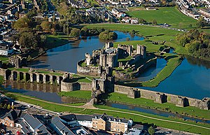
Caerphilly Castle (Welsh: Castell Caerffili) is a medieval fortification in Caerphilly in South Wales. The castle was constructed by Gilbert de Clare in the 13th century as part of his campaign to maintain control of Glamorgan, and saw extensive fighting between Gilbert, his descendants, and the native Welsh rulers. Surrounded by extensive artificial lakes – considered by historian Allen Brown to be "the most elaborate water defences in all Britain" – it occupies around 30 acres (12 ha) and is the largest castle in Wales and the second-largest castle in the United Kingdom after Windsor Castle.
Castle Park, Caerphilly
Distance: Approx. 473 meters
Latitude and longitude: 51.57611111,-3.21166667
Castle Park is a residential area of the town of Caerphilly, south Wales. As the name suggests, it is located near Caerphilly Castle.

Caerphilly (UK Parliament constituency)
Parliamentary constituency in the United Kingdom, 1918 onwards
Distance: Approx. 501 meters
Latitude and longitude: 51.579,-3.218
Caerphilly (Welsh: Caerffili) is a constituency centred on the town of Caerphilly in South Wales, represented in the House of Commons of the UK Parliament since 2024 by Chris Evans of the Labour Party. Since its creation, the constituency has always elected Labour MPs, although the predecessor constituency of East Glamorganshire, and prior to that Glamorganshire had elected Liberal MPs throughout the Victorian era.

Caerphilly railway works
Former engineering facility in Wales
Distance: Approx. 1036 meters
Latitude and longitude: 51.57138889,-3.20388889
Caerphilly railway works in Caerphilly (Welsh: Caerffili) in the county of Glamorgan was the only main railway works in Wales. It was built for the Rhymney Railway in 1899 and taken over by the Great Western Railway at amalgamation in 1923. Much of its initial work was in refurbishing older locomotives with new boilers and covered cabs.

Van, Caerphilly
Human settlement in Wales
Distance: Approx. 900 meters
Latitude and longitude: 51.5711,-3.2062
Van (Welsh: Y Fan) is a suburb and community in Caerphilly county borough in Wales, situated in the east of the town of Caerphilly. It contains the vast housing estate of Lansbury Park and the estates of Porset Park, Castle Park, Mornington Meadows and Badgers Wood. Van mainly consists of residential properties, one industrial estate and only one public house - The Fisherman's Rest.

Aber railway station
Railway station in Caerphilly, Wales
Distance: Approx. 824 meters
Latitude and longitude: 51.5749,-3.2299
Aber railway station is a railway station serving the town of Caerphilly, south Wales. It is a stop on the Rhymney Line 8+1⁄4 miles (13.3 km) north of Cardiff Central on the Valley Lines network. The station is located in the Bondfield Park and Trecenydd areas of Caerphilly.

Caerphilly railway station
Railway station in Caerphilly, Wales
Distance: Approx. 337 meters
Latitude and longitude: 51.5715,-3.2186
Caerphilly railway station (Welsh: Gorsaf reilffordd Caerffili) is a railway station serving the town of Caerphilly, south Wales. It is a stop on the Rhymney Line of the Valley Lines network. The station is located at Station Road in the south of the town.

Caerphilly (Senedd constituency)
Constituency of the Senedd
Distance: Approx. 501 meters
Latitude and longitude: 51.579,-3.218
Caerphilly (Welsh: Caerffili) is a constituency of the Senedd. It elects one Member of the Senedd by the first past the post method of election. It is additionally one of eight constituencies in the South Wales East electoral region, which elects four additional members, in addition to eight constituency members, to produce a degree of proportional representation for the region as a whole.

Virginia Park (Caerphilly)
Distance: Approx. 819 meters
Latitude and longitude: 51.58183333,-3.217
Virginia Park is a rugby ground, cricket ground and former greyhound racing stadium in Caerphilly, South Wales.

St Martin's Comprehensive School
Comprehensive school in Caerphilly, Caerphilly County Borough, Wales
Distance: Approx. 619 meters
Latitude and longitude: 51.56916667,-3.22055556
St Martin's Comprehensive School is a comprehensive school in the County borough of Caerphilly in Mid Glamorgan, Wales. It is located in Caerphilly town.

Twyn Community Centre
Municipal Building in Caerphilly, Wales
Distance: Approx. 21 meters
Latitude and longitude: 51.5745,-3.2177
Twyn Community Centre (Welsh: Canolfan Gymunedol Twyn) is a municipal building in The Twyn Square in Caerphilly, Wales. The structure, which was commissioned as a Calvinistic Methodist Chapel, now accommodates the offices and meeting place of Caerphilly Town Council.
Weather in this IP's area
overcast clouds
9 Celsius
9 Celsius
8 Celsius
9 Celsius
1024 hPa
90 %
1024 hPa
1013 hPa
10000 meters
0.45 m/s
1.79 m/s
134 degree
99 %
07:21:18
16:32:14