Country:
 Switzerland
Region:
City:
Latitude and Longitude:
Time Zone:
Postal Code:
IP information under different IP Channel
ip-api
Country
Region
City
ASN
Time Zone
ISP
Blacklist
Proxy
Latitude
Longitude
Postal
Route
IPinfo
Country
Region
City
ASN
Time Zone
ISP
Blacklist
Proxy
Latitude
Longitude
Postal
Route
MaxMind
Country
Region
City
ASN
Time Zone
ISP
Blacklist
Proxy
Latitude
Longitude
Postal
Route
Luminati
Country
CHRegion
vd
City
prangins
ASN
Time Zone
Europe/Zurich
ISP
netplus.ch SA
Latitude
Longitude
Postal
db-ip
Country
Region
City
ASN
Time Zone
ISP
Blacklist
Proxy
Latitude
Longitude
Postal
Route
ipdata
Country
Region
City
ASN
Time Zone
ISP
Blacklist
Proxy
Latitude
Longitude
Postal
Route
Popular places and events near this IP address
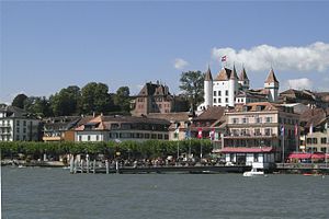
Nyon
Place in Vaud, Switzerland
Distance: Approx. 2371 meters
Latitude and longitude: 46.38333333,6.23333333
Nyon (French pronunciation: [njɔ̃] ; historically German: Neuis or Neuss and Italian: Nione, [ˈnjoːne]) is a municipality in Nyon District in the canton of Vaud in Switzerland. It is located some 25 kilometers north east of Geneva's city centre, and since the 1970s it has become part of the Geneva metropolitan area. It lies on the shores of Lake Geneva and is the seat of Nyon District.

Prangins
Municipality in Vaud, Switzerland
Distance: Approx. 1585 meters
Latitude and longitude: 46.4,6.25
Prangins (French pronunciation: [pʁɑ̃ʒɛ̃]) is a municipality in the district of Nyon in the canton of Vaud in Switzerland. It is located on Lake Geneva.

Toblerone line
Defensive fortifications of Vaud, Switzerland from WWII
Distance: Approx. 1966 meters
Latitude and longitude: 46.40216667,6.28016667
The Toblerone line is a 10 km long defensive line made of "dragon's teeth" fortifications built during the Second World War between Bassins and Prangins, in the Canton of Vaud, Switzerland. These lines of defensive blocks can be found all over Switzerland, though more commonly in border areas. Their purpose was to stop tank invasions.

HBG (time signal)
Time signal radio station in Switzerland
Distance: Approx. 2296 meters
Latitude and longitude: 46.408356,6.252769
HBG was a low frequency time signal transmitter for the Swiss time reference system. It transmitted on 75 kHz with 20 kW power, and was located in Prangins, Switzerland. Due to the cost of urgently needed renovation for the ageing antennas, and the ease with which all existing users could switch to the DCF77 time signal, the Swiss Federal Government decided to shut down HBG at the end of 2011.
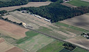
La Côte Airfield
Private airfield in Switzerland
Distance: Approx. 1974 meters
Latitude and longitude: 46.40638889,6.25805556
The La Côte Airfield (ICAO code LSGP) is a private airfield in Prangins, Switzerland. It hosted a fly-in in 2009, 2011, 2013, on August 15, 2015 and in 2019.
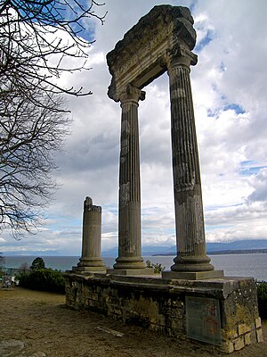
Noviodunum (Switzerland)
Archaeological site in Vaud, Switzerland
Distance: Approx. 2123 meters
Latitude and longitude: 46.381,6.238
Noviodunum or Colonia Iulia Equestris was a Roman era settlement in what is now Nyon in the Canton of Vaud in Switzerland.

Nyon Castle
Castle in Nyon, Switzerland
Distance: Approx. 1885 meters
Latitude and longitude: 46.38218,6.24063
Nyon Castle is a castle in the municipality of Nyon of the Canton of Vaud in Switzerland. It is a Swiss heritage site of national significance.

Duillier Castle
Castle in Duillier, Switzerland
Distance: Approx. 2974 meters
Latitude and longitude: 46.406822,6.234244
Duillier Castle is a castle in the municipality of Duillier of the Canton of Vaud in Switzerland. It is a Swiss heritage site of national significance.
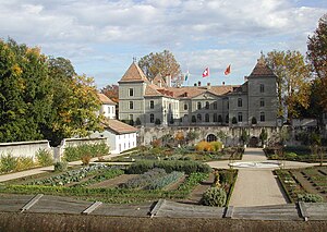
Prangins Castle
Castle in Prangins, Switzerland
Distance: Approx. 1030 meters
Latitude and longitude: 46.39416,6.25196
Prangins Castle is a castle in the municipality of Prangins of the Canton of Vaud in Switzerland. It is a Swiss heritage site of national significance. It is home to one part of the Swiss National Museum.

Sustainability Management School
Swiss business school
Distance: Approx. 3187 meters
Latitude and longitude: 46.415585,6.27851821
Sustainability Management School (SUMAS) is a private business school focused on sustainability and a responsible management education (UN Sustainable Development Knowledge Program, Voluntary Initiative). This training center was founded in 2012 by Ivana Modena with the mission of Inspiring Innovative Leaders. SUMAS's main campus is based in the headquarters of the International Union for Conservation of Nature (IUCN) and World Wide Fund for Nature (WWF), just neighbors without any connection, in Gland in the French-speaking part of Switzerland.

Gland railway station
Railway station in Gland, Switzerland
Distance: Approx. 3482 meters
Latitude and longitude: 46.42,6.26911111
Gland railway station (French: Gare de Gland) is a railway station in the municipality of Gland, in the Swiss canton of Vaud. It is an intermediate stop on the standard gauge Lausanne–Geneva line of Swiss Federal Railways.

Nyon railway station
Railway station in Nyon, Switzerland
Distance: Approx. 2143 meters
Latitude and longitude: 46.38438889,6.236
Nyon railway station (French: Gare de Nyon) is a railway station in the municipality of Nyon, in the Swiss canton of Vaud. It is an intermediate stop on the standard gauge Lausanne–Geneva line of Swiss Federal Railways and the southern terminus of the 1,000 mm (3 ft 3+3⁄8 in) gauge Nyon–St-Cergue–Morez line of the Chemin de fer Nyon–St-Cergue–Morez.
Weather in this IP's area
moderate rain
15 Celsius
14 Celsius
14 Celsius
16 Celsius
1005 hPa
94 %
1005 hPa
962 hPa
10000 meters
0.61 m/s
1.79 m/s
72 degree
100 %
07:42:54
19:01:38