Country:
 Switzerland
Region:
City:
Latitude and Longitude:
Time Zone:
Postal Code:
IP information under different IP Channel
ip-api
Country
Region
City
ASN
Time Zone
ISP
Blacklist
Proxy
Latitude
Longitude
Postal
Route
IPinfo
Country
Region
City
ASN
Time Zone
ISP
Blacklist
Proxy
Latitude
Longitude
Postal
Route
MaxMind
Country
Region
City
ASN
Time Zone
ISP
Blacklist
Proxy
Latitude
Longitude
Postal
Route
Luminati
Country
CHRegion
vs
City
bassenendaz
ASN
Time Zone
Europe/Zurich
ISP
netplus.ch SA
Latitude
Longitude
Postal
db-ip
Country
Region
City
ASN
Time Zone
ISP
Blacklist
Proxy
Latitude
Longitude
Postal
Route
ipdata
Country
Region
City
ASN
Time Zone
ISP
Blacklist
Proxy
Latitude
Longitude
Postal
Route
Popular places and events near this IP address

Battle on the Planta
1475 battle in Europe
Distance: Approx. 3939 meters
Latitude and longitude: 46.21666667,7.35
The Battle on the Planta, fought on 13 November 1475 around Conthey near Sion, Valais, Switzerland, was part of the Burgundian Wars.
Omega European Masters
Golf tournament
Distance: Approx. 3077 meters
Latitude and longitude: 46.18,7.28
The Omega European Masters is the Swiss stop on professional men's golf's European Tour, and in 2009 it became the first event in Europe to be co-sanctioned by the Asian Tour. Founded as the Swiss Open in 1923, the tournament was prefixed with European Masters in 1983, before dropping Swiss Open from the title in 1992. During the 1971 event, Baldovino Dassù became the first player to score 60 for 18 holes on the European circuit.

Veysonnaz
Municipality in Valais, Switzerland
Distance: Approx. 1383 meters
Latitude and longitude: 46.18333333,7.33333333
Veysonnaz is a municipality in the district of Sion in the Swiss canton of Valais.
Conthey District
District in Switzerland
Distance: Approx. 3479 meters
Latitude and longitude: 46.20472222,7.27833333
The district of Conthey (French: District de Conthey, German: Bezirk Gundis) is an administrative district in the canton of Valais, Switzerland. It has a population of 29,424 (as of 31 December 2020). The Conthey district was created as the 13th district of the Valais as the canton joined the restored Swiss Confederacy in 1815, accounting for the thirteen stars in the coat of arms of Valais.

Conthey
Municipality in Valais, Switzerland
Distance: Approx. 3335 meters
Latitude and longitude: 46.21666667,7.3
Conthey (French pronunciation: [kɔ̃tɛ]) is a municipality in the district of Conthey in the canton of Valais in Switzerland.

Nendaz
Municipality in Valais, Switzerland
Distance: Approx. 1510 meters
Latitude and longitude: 46.18333333,7.3
Nendaz is a municipality in the district of Conthey in the canton of Valais in Switzerland.
Haute-Nendaz
Municipality in Valais, Switzerland
Distance: Approx. 1471 meters
Latitude and longitude: 46.18666667,7.29888889
Haute-Nendaz is a village in the municipality of Nendaz, Canton Valais, Switzerland. It is situated on plateau at an altitude between 1300m and 1500m. In winter, it forms part of the 4 Vallées ski resort and is one of the most extensive ski areas in Europe, with a ski area of over 400 km.

Dent de Nendaz
Mountain in Switzerland
Distance: Approx. 4207 meters
Latitude and longitude: 46.15611111,7.2915
The Dent de Nendaz (literally "Tooth of Nendaz") is a mountain of the Swiss Pennine Alps, overlooking Nendaz in the canton of Valais. Its 2,463-metre-high (8,081 ft) summit can be easily reached from the cable car station of Tracouet (2,200 m).

Lac de Tracouet
Distance: Approx. 4195 meters
Latitude and longitude: 46.15972222,7.28388889
Lac de Tracouet (also Lac Noir, "Black Lake") is a lake in the Nendaz municipality in the canton of Valais, Switzerland. It is situated at the foot of the Dent de Nendaz at an elevation of 2,171 m. The lake can be reached by cable car or by foot from Haute-Nendaz to Tracouet (2,200 m) followed by a slight descent to the lake surface.

Thyon
Distance: Approx. 4310 meters
Latitude and longitude: 46.18194444,7.3725
Thyon (also known as Thyon 2000) is a purpose-built ski resort in the Swiss Alps, located in the canton of Valais. The resort is situated in the central part of the canton, in the region of Sion, and is associated with the village of Les Collons. It forms part of the "4 Valleys" interlinked ski area, which together includes Thyon, Veysonnaz, Haute-Nendaz, Verbier and La Tzoumaz.

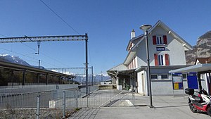
Châteauneuf-Conthey railway station
Railway station in Conthey, Switzerland
Distance: Approx. 3136 meters
Latitude and longitude: 46.21610889,7.30510194
Châteauneuf-Conthey railway station (French: Gare de Châteauneuf-Conthey, German: Bahnhof Châteauneuf-Conthey) is a railway station in the municipality of Conthey, in the Swiss canton of Valais. It is an intermediate stop on the Simplon line and is served by local trains only.
Ardon railway station
Railway station in Ardon, Switzerland
Distance: Approx. 4187 meters
Latitude and longitude: 46.20859389,7.27094694
Ardon railway station (French: Gare d'Ardon, German: Bahnhof Ardon) is a railway station in the municipality of Ardon, in the Swiss canton of Valais. It is an intermediate stop on the Simplon line and is served by local trains only.
Weather in this IP's area
broken clouds
8 Celsius
7 Celsius
7 Celsius
9 Celsius
1018 hPa
86 %
1018 hPa
906 hPa
10000 meters
1.85 m/s
2.26 m/s
113 degree
54 %
07:53:26
18:37:31