Country:
Region:
City:
Latitude and Longitude:
Time Zone:
Postal Code:
IP information under different IP Channel
ip-api
Country
Region
City
ASN
Time Zone
ISP
Blacklist
Proxy
Latitude
Longitude
Postal
Route
Luminati
Country
ASN
Time Zone
Europe/Madrid
ISP
acens Technologies, S.L.
Latitude
Longitude
Postal
IPinfo
Country
Region
City
ASN
Time Zone
ISP
Blacklist
Proxy
Latitude
Longitude
Postal
Route
db-ip
Country
Region
City
ASN
Time Zone
ISP
Blacklist
Proxy
Latitude
Longitude
Postal
Route
ipdata
Country
Region
City
ASN
Time Zone
ISP
Blacklist
Proxy
Latitude
Longitude
Postal
Route
Popular places and events near this IP address

Zaragoza Airport
International airport serving Zaragoza, Aragón, Spain
Distance: Approx. 5877 meters
Latitude and longitude: 41.66611111,-1.04166667
Zaragoza Airport (Aragonese and Spanish: Aeropuerto de Zaragoza; IATA: ZAZ, ICAO: LEZG) is an international airport near Zaragoza, Aragón, Spain. It is located 16 km (9.9 miles) west of Zaragoza, 270 km (170 miles) west of Barcelona, and 262 km (163 miles) northeast of Madrid. In addition to serving as a major cargo airport, it is also a commercial airport and, as Zaragoza Air Base, is the home of the Spanish Air and Space Force 15th Group.
La Joyosa
Municipality in Aragon, Spain
Distance: Approx. 7280 meters
Latitude and longitude: 41.75,-1.06666667
La Joyosa is a municipality located in the province of Zaragoza, Aragon, Spain. According to the 2004 census (INE), the municipality has a population of 609 inhabitants.

Pinseque
Place in Aragon, Spain
Distance: Approx. 8830 meters
Latitude and longitude: 41.73333333,-1.1
Pinseque is a municipality located in the province of Zaragoza, Aragon, Spain. According to the 2014 census (INE), the municipality has a population of 3,625 inhabitants, with a population density of 224.88 people per km² (582.4 per square mile).
Sobradiel
Municipality in Aragon, Spain
Distance: Approx. 3978 meters
Latitude and longitude: 41.73333333,-1.03333333
Sobradiel is a municipality located in the province of Zaragoza, Aragon, Spain. According to the 2004 census (INE), the municipality has a population of 752 inhabitants.

Torres de Berrellén
Place in Aragon, Spain
Distance: Approx. 7280 meters
Latitude and longitude: 41.75,-1.06666667
Torres de Berrellén is a municipality located in the province of Zaragoza, Aragon, Spain. According to the 2004 census (INE), the municipality has a population of 1450 inhabitants. Its population density is 28,08 inhabitants per square kilometre (70/sq mi).

Utebo
Place in Aragon, Spain
Distance: Approx. 934 meters
Latitude and longitude: 41.71666667,-1
Utebo (Aragonese: Utevo) is a town located in the province of Zaragoza, Aragon, Spain. At the time of the 2011 census (INE), the municipality had a population of 18,602 inhabitants, being the third most populous town of the province, only surpassed by Zaragoza and Calatayud, and one of the most populous in Aragon.

Torre del Agua
Tower in Zaragoza, Spain
Distance: Approx. 8701 meters
Latitude and longitude: 41.67055556,-0.9075
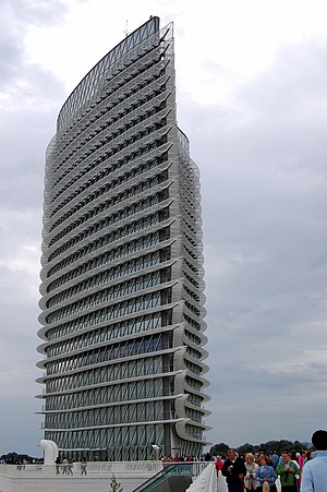
The Torre del Agua (Spanish: Water Tower) is a 76-metre-high (249 ft) tower built at the Expo 2008 site in Zaragoza, Spain. It was designed by Enrique de Teresa and constructed of concrete, steel and glass. Seen from above, the structure has a droplet-of-water shape.

Bridge Pavilion
Building in Zaragoza, Spain
Distance: Approx. 9093 meters
Latitude and longitude: 41.666701,-0.905031
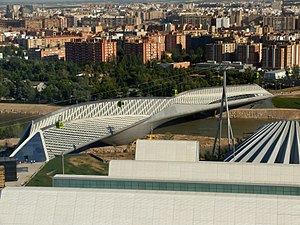
The Bridge Pavilion (Spanish: Pabellón Puente) is a building designed by British-Iraqi architect Zaha Hadid that was constructed for the Expo 2008 in Zaragoza (Spain) as one of its main landmarks. It is an innovative 280-metre-long (919 ft) covered bridge that imitates a gladiola over the river Ebro, connecting the neighbourhood of La Almozara with the exposition site, and thus becoming its main entrance. The new bridge is, at the same time, a multi-level exhibition area; 10,000 visitors per hour were expected to frequent the Pavilion during world exhibition.
Zaragoza–Delicias railway station
Railway station in Spain
Distance: Approx. 9175 meters
Latitude and longitude: 41.65861111,-0.91111111
Zaragoza–Delicias station is a railway station located in the city of Zaragoza in Aragon, Spain. The station opened on 7 May 2003, and the Central Bus Station Zaragoza opened on 5 May 2007, providing a wide intermodality to passengers. It is served by the AVE high-speed trains between Madrid and Barcelona and onwards to Figueres.
Casetas
Place in Aragon, Spain
Distance: Approx. 2634 meters
Latitude and longitude: 41.7189,-1.0275
Casetas is a borough of Zaragoza (Spain) located 15 km west of the city.
Juslibol
Distance: Approx. 8293 meters
Latitude and longitude: 41.7,-0.9
Juslibol is a rural district of the city of Zaragoza, Spain. As of 2013, it has a population of 1518 inhabitants.

Zaragoza Air Base
Airport
Distance: Approx. 5877 meters
Latitude and longitude: 41.66611111,-1.04166667
Zaragoza Air Base (IATA: ZAZ, ICAO: LEZG) is a base of the Spanish Air and Space Force located near Zaragoza, Spain. It is located 16 kilometres (10 mi) west of Zaragoza, 270 km (168 mi) west of Barcelona, and 262 km (163 mi) northeast of Madrid. It shares infrastructure with the Zaragoza Airport.
Weather in this IP's area
clear sky
16 Celsius
16 Celsius
15 Celsius
17 Celsius
1018 hPa
64 %
1018 hPa
993 hPa
10000 meters
5.14 m/s
290 degree
07:57:17
17:41:29

