Country:
 Slovakia
Region:
City:
Latitude and Longitude:
Time Zone:
Postal Code:
IP information under different IP Channel
ip-api
Country
Region
City
ASN
Time Zone
ISP
Blacklist
Proxy
Latitude
Longitude
Postal
Route
IPinfo
Country
Region
City
ASN
Time Zone
ISP
Blacklist
Proxy
Latitude
Longitude
Postal
Route
MaxMind
Country
Region
City
ASN
Time Zone
ISP
Blacklist
Proxy
Latitude
Longitude
Postal
Route
Luminati
Country
SKRegion
zi
City
namestovo
ASN
Time Zone
Europe/Bratislava
ISP
DSI DATA, a. s.
Latitude
Longitude
Postal
db-ip
Country
Region
City
ASN
Time Zone
ISP
Blacklist
Proxy
Latitude
Longitude
Postal
Route
ipdata
Country
Region
City
ASN
Time Zone
ISP
Blacklist
Proxy
Latitude
Longitude
Postal
Route
Popular places and events near this IP address
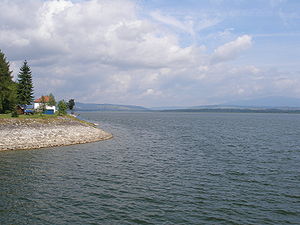
Orava (reservoir)
Reservoir in Slovakia, Poland
Distance: Approx. 4479 meters
Latitude and longitude: 49.39972222,19.54555556
Orava (Slovak: Oravská priehrada) is a reservoir in northernmost Slovakia, forming the largest lake in Slovakia (35.2 km2).
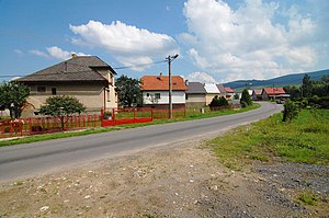
Ťapešovo
Municipality in Slovakia
Distance: Approx. 4333 meters
Latitude and longitude: 49.37972222,19.43833333
Ťapešovo (Hungarian: Tyapessó) is municipality (village) near Námestovo, Žilina Region, Slovakia. It is located on the Biela Orava river. The first written mention of Ťapešovo comes from 1580.
Námestovo District
District in Žilina Region, Slovakia
Distance: Approx. 189 meters
Latitude and longitude: 49.40638889,19.48388889
Námestovo District (okres Námestovo) is a district in the Žilina Region of central Slovakia. Until 1918, the district was part of Árva County, an administrative division of the Kingdom of Hungary.

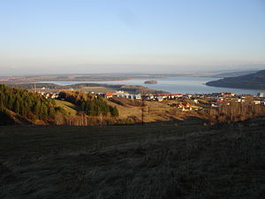
Námestovo
Town in Slovakia
Distance: Approx. 295 meters
Latitude and longitude: 49.40277778,19.48138889
Námestovo (Hungarian: Námesztó; Polish: Namiestów) is a town in northern Slovakia. It is the capital and largest town of Námestovo District in the Žilina Region. As of 2018 its population was 7,827.
Bobrov, Slovakia
Village and municipality in Slovakia
Distance: Approx. 5733 meters
Latitude and longitude: 49.43333333,19.55
Bobrov (Hungarian: Bobró) is a village and municipality in Námestovo District in the Žilina Region of northern Slovakia.

Štefanov nad Oravou
Distance: Approx. 5420 meters
Latitude and longitude: 49.36388889,19.525
Štefanov nad Oravou (Hungarian: Stepanó) is a village and municipality in Tvrdošín District in the Žilina Region of northern Slovakia.

Zubrohlava
Municipality in Slovakia
Distance: Approx. 5564 meters
Latitude and longitude: 49.45,19.51666667
Zubrohlava is a village and municipality in Námestovo District in the Žilina Region of northern Slovakia.

Klin, Námestovo District
Distance: Approx. 3961 meters
Latitude and longitude: 49.44027778,19.48333333
Klin is a village and municipality in Námestovo District in the Žilina Region of northern Slovakia.

Oravská Jasenica
Distance: Approx. 3935 meters
Latitude and longitude: 49.38861111,19.43583333
Oravská Jasenica (Hungarian: Jaszenica) is a village and municipality in Námestovo District in the Žilina Region of northern Slovakia.
Vavrečka
Village and municipality in Žilina Region, Slovakia
Distance: Approx. 2697 meters
Latitude and longitude: 49.38333333,19.46666667
Vavrečka (Hungarian: Vavrecska) is a village and municipality in Námestovo District in the Žilina Region of northern Slovakia.

Bird Island, Slovakia
Distance: Approx. 2061 meters
Latitude and longitude: 49.4125,19.51
Bird Island (Slovak: Vtáčí ostrov) is a 6.86-hectare (17.0-acre) island in the Hrušovská zdrž (2518 ha), which is part of Gabčíkovo Reservoir, south-west of Šamorín, Slovakia. The island was built because of the constructions of the Gabčíkovo-Nagymaros dams on the Danube as habitat compensation for areas consequently flooded. The island is part of proposed special protected areas Dunajské luhy for waterbirds.
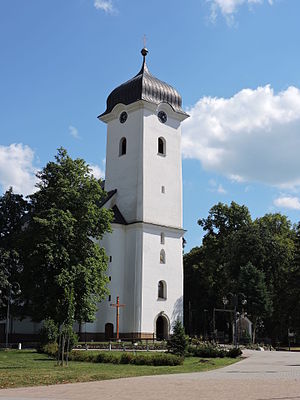
Namestovo church
Distance: Approx. 98 meters
Latitude and longitude: 49.40555556,19.48388889
The Namestovo church is in Námestovo in what is now Slovakia. The oldest record of a Christian congregation in this location is from 1555; however the church building is believed to have been constructed between 1655 and 1658. This was a chapel which now serves as an entry to the church.
Weather in this IP's area
few clouds
10 Celsius
10 Celsius
9 Celsius
10 Celsius
1025 hPa
94 %
1025 hPa
954 hPa
10000 meters
1.51 m/s
1.49 m/s
50 degree
21 %
06:24:29
18:47:11