77.223.175.82 - IP Lookup: Free IP Address Lookup, Postal Code Lookup, IP Location Lookup, IP ASN, Public IP
Country:
Region:
City:
Location:
Time Zone:
Postal Code:
ISP:
ASN:
language:
User-Agent:
Proxy IP:
Blacklist:
IP information under different IP Channel
ip-api
Country
Region
City
ASN
Time Zone
ISP
Blacklist
Proxy
Latitude
Longitude
Postal
Route
db-ip
Country
Region
City
ASN
Time Zone
ISP
Blacklist
Proxy
Latitude
Longitude
Postal
Route
IPinfo
Country
Region
City
ASN
Time Zone
ISP
Blacklist
Proxy
Latitude
Longitude
Postal
Route
IP2Location
77.223.175.82Country
Region
more og romsdal
City
tingvoll
Time Zone
Europe/Oslo
ISP
Language
User-Agent
Latitude
Longitude
Postal
ipdata
Country
Region
City
ASN
Time Zone
ISP
Blacklist
Proxy
Latitude
Longitude
Postal
Route
Popular places and events near this IP address

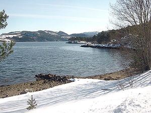
Tingvoll
Municipality in Møre og Romsdal, Norway
Distance: Approx. 4545 meters
Latitude and longitude: 62.95361111,8.21805556
Tingvoll is a municipality in Møre og Romsdal county, Norway. It is part of the Nordmøre region. The administrative centre is the village of Tingvollvågen.

Angvik
Village in Western Norway, Norway
Distance: Approx. 6485 meters
Latitude and longitude: 62.8922,8.086
Angvik or Angvika is a small village in Gjemnes Municipality in Møre og Romsdal county, Norway. The village is located along the western shores of the Tingvollfjorden, just across the fjord from the village of Tingvollvågen. The population of Angvik is about 300.
Rausand
Village in Western Norway, Norway
Distance: Approx. 9420 meters
Latitude and longitude: 62.837,8.1246
Raudsand or Rausand is a village in Molde Municipality in Møre og Romsdal county, Norway. It is located on the Romsdal peninsula along the Tingvollfjorden about 9 kilometres (5.6 mi) northeast of the village of Eidsvåg and 8 kilometres (5.0 mi) south of the village of Angvika in Gjemnes Municipality. The 0.43-square-kilometre (110-acre) village had a population (in 2018) of 276 and a population density of 642 per square kilometre (1,660/sq mi).
Trongfjord
Fjord in Møre og Romsdal, Norway
Distance: Approx. 9389 meters
Latitude and longitude: 62.9818,8.3132
Trongfjorden is a fjord between Surnadal Municipality and Tingvoll Municipality in Møre og Romsdal county, Norway. The fjord is approximately 4 kilometres (2.5 mi) long and is a continuation of the Halsafjorden on the north end near the village of Torjulvågen in Tingvoll Municipality. On the south end, the fjord branches off into several other fjord arms: Hamnesfjorden, Surnadalsfjorden, Stangvikfjorden, and Ålvundfjorden.

Tingvoll Church
Church in Møre og Romsdal, Norway
Distance: Approx. 1210 meters
Latitude and longitude: 62.91185553,8.18160251
Tingvoll Church (Norwegian: Tingvoll kyrkje) is a parish church of the Church of Norway in Tingvoll Municipality in Møre og Romsdal county, Norway. It is located in the village of Tingvollvågen. It is the church for the Tingvoll parish which is part of the Indre Nordmøre prosti (deanery) in the Diocese of Møre.

Flemma
Village in Western Norway, Norway
Distance: Approx. 7052 meters
Latitude and longitude: 62.9357,8.0752
Flemma is a village in Gjemnes Municipality in Møre og Romsdal county, Norway. The village lies along the Tingvollfjorden, about 6 kilometres (3.7 mi) north of the village of Angvika. The mountain Reinsfjellet lies about 7 kilometres (4.3 mi) to the west.

Tingvollvågen
Village in Møre og Romsdal county, Norway
Distance: Approx. 19 meters
Latitude and longitude: 62.9131,8.2056
Tingvollvågen or Tingvoll is the administrative centre of Tingvoll Municipality in Møre og Romsdal county, Norway. The village is located on a small inlet off the Tingvollfjorden, directly across the fjord from the village of Angvika (in Gjemnes Municipality). Tingvollvågen lies about 10 kilometres (6.2 mi) north of the village of Meisingset and about 20 kilometres (12 mi) south of the village of Straumsnes.
Weather in this IP's area
overcast clouds
5 Celsius
4 Celsius
5 Celsius
5 Celsius
991 hPa
84 %
991 hPa
956 hPa
10000 meters
2.25 m/s
2.48 m/s
149 degree
100 %