77.223.162.36 - IP Lookup: Free IP Address Lookup, Postal Code Lookup, IP Location Lookup, IP ASN, Public IP
Country:
Region:
City:
Location:
Time Zone:
Postal Code:
IP information under different IP Channel
ip-api
Country
Region
City
ASN
Time Zone
ISP
Blacklist
Proxy
Latitude
Longitude
Postal
Route
Luminati
Country
Region
15
City
nedrefrei
ASN
Time Zone
Europe/Oslo
ISP
Neas Energi Telekom As
Latitude
Longitude
Postal
IPinfo
Country
Region
City
ASN
Time Zone
ISP
Blacklist
Proxy
Latitude
Longitude
Postal
Route
IP2Location
77.223.162.36Country
Region
more og romsdal
City
hopen
Time Zone
Europe/Oslo
ISP
Language
User-Agent
Latitude
Longitude
Postal
db-ip
Country
Region
City
ASN
Time Zone
ISP
Blacklist
Proxy
Latitude
Longitude
Postal
Route
ipdata
Country
Region
City
ASN
Time Zone
ISP
Blacklist
Proxy
Latitude
Longitude
Postal
Route
Popular places and events near this IP address

Smøla
Municipality in Møre og Romsdal, Norway
Distance: Approx. 6883 meters
Latitude and longitude: 63.40194444,8.02916667
Smøla is a municipality in Møre og Romsdal county, Norway. It is part of the Nordmøre region. The administrative centre of the municipality is the village of Hopen, other villages include Dyrnes, Råket, and Veiholmen.
Hopen, Møre og Romsdal
Village in Western Norway, Norway
Distance: Approx. 224 meters
Latitude and longitude: 63.4654,8.0144
Hopen is the administrative center of Smøla Municipality in Møre og Romsdal county, Norway. The village lies east of the villages of Dyrnes and Råket on the northern coast of the island of Smøla. The main road through Hopen is Norwegian County Road 669 which also heads north connecting many small islands and ending at the island village of Veiholmen.
Dyrnes
Village in Western Norway, Norway
Distance: Approx. 9028 meters
Latitude and longitude: 63.4256,7.8534
Dyrnes is a village in Smøla Municipality in Møre og Romsdal county, Norway. It is located on the northwestern part of the island of Smøla, just east of the village of Råket, and southwest of the village of Veiholmen. The Smøla Wind Farm is located southeast of the village.

Veiholmen
Village and island group in Western Norway, Norway
Distance: Approx. 6889 meters
Latitude and longitude: 63.51888889,7.9525
Veiholmen is a fishing village located on a group of tiny islands in the northern part of Smøla Municipality in Møre og Romsdal county, Norway. The island is located at the end of a 7-kilometre (4.3 mi) long road leading north from the village of Hopen. The road goes over many islands connecting Veiholmen to the island of Smøla to the south.

Smøla Wind Farm
Wind farm in Norway
Distance: Approx. 7710 meters
Latitude and longitude: 63.407,7.924
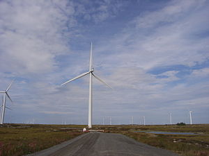
Smøla Wind Farm (Smøla vindpark) is a 68-turbine wind farm located in Smøla Municipality in Møre og Romsdal county, Norway. The farm is located southeast of the village of Dyrnes on the island of Smøla. It is operated by Statkraft and covers an area of 18 square kilometres (6.9 sq mi).

Haugjegla Lighthouse
Coastal lighthouse in Norway
Distance: Approx. 8193 meters
Latitude and longitude: 63.53333333,7.9625
Haugjegla Lighthouse (Norwegian: Haugjegla fyr; also spelled: Hauggjegla) is a coastal lighthouse located in Smøla Municipality in Møre og Romsdal county, Norway. It is located on a waveswept skerry about 1 kilometre (0.62 mi) north of Veiholmen on the north side of the island of Smøla. The lighthouse is only accessible by boat.
Hopen Church
Church in Møre og Romsdal, Norway
Distance: Approx. 283 meters
Latitude and longitude: 63.4659351,8.01337436
Hopen Church (Norwegian: Hopen kirke) is a parish church of the Church of Norway in Smøla Municipality in Møre og Romsdal county, Norway. It is located in the village of Hopen, along the northern coast of the island of Smøla. It is the church for the Hopen parish which is part of the Ytre Nordmøre prosti (deanery) in the Diocese of Møre.

Hopen Municipality
Former municipality in Norway
Distance: Approx. 7 meters
Latitude and longitude: 63.46333333,8.01388889
Hopen is a former municipality in Møre og Romsdal county, Norway. The 50-square-kilometre (19 sq mi) municipality existed from 1915 until its dissolution in 1960. It covered the northeastern part of the island of Smøla, plus the small islands to the north such as Veiholmen, Hammarøya, and Haugøya.
Weather in this IP's area
light rain
3 Celsius
-2 Celsius
3 Celsius
3 Celsius
1015 hPa
66 %
1015 hPa
1015 hPa
10000 meters
8.33 m/s
12.94 m/s
172 degree
100 %
