77.222.253.102 - IP Lookup: Free IP Address Lookup, Postal Code Lookup, IP Location Lookup, IP ASN, Public IP
Country:
Region:
City:
Location:
Time Zone:
Postal Code:
ISP:
ASN:
language:
User-Agent:
Proxy IP:
Blacklist:
IP information under different IP Channel
ip-api
Country
Region
City
ASN
Time Zone
ISP
Blacklist
Proxy
Latitude
Longitude
Postal
Route
db-ip
Country
Region
City
ASN
Time Zone
ISP
Blacklist
Proxy
Latitude
Longitude
Postal
Route
IPinfo
Country
Region
City
ASN
Time Zone
ISP
Blacklist
Proxy
Latitude
Longitude
Postal
Route
IP2Location
77.222.253.102Country
Region
swietokrzyskie
City
skarzysko-kamienna
Time Zone
Europe/Warsaw
ISP
Language
User-Agent
Latitude
Longitude
Postal
ipdata
Country
Region
City
ASN
Time Zone
ISP
Blacklist
Proxy
Latitude
Longitude
Postal
Route
Popular places and events near this IP address

Skarżysko-Kamienna
Place in Świętokrzyskie Voivodeship, Poland
Distance: Approx. 3174 meters
Latitude and longitude: 51.11666667,20.91666667
Skarżysko-Kamienna (pronounced [skarˈʐɨskɔ kaˈmʲɛnːa] ) is a city in northern Świętokrzyskie Voivodeship in south-central Poland by Kamienna river, to the north of Świętokrzyskie Mountains; one of the voivodship's major cities. Prior to 1928, it bore the name of Kamienna; in less formal contexts usually only the first part of the name (Skarżysko) is used. It belongs to historic Polish province of Lesser Poland.

Skarżysko County
County in Świętokrzyskie Voivodeship, Poland
Distance: Approx. 3174 meters
Latitude and longitude: 51.11666667,20.91666667
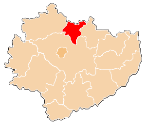
Skarżysko County (Polish: powiat skarżyski) is a unit of territorial administration and local government (powiat) in Świętokrzyskie Voivodeship, south-central Poland. It came into being on January 1, 1999, as a result of the Polish local government reforms passed in 1998. Its administrative seat and largest town is Skarżysko-Kamienna, which lies 34 kilometres (21 mi) north-east of the regional capital Kielce.

Skarżysko Kościelne
Place in Świętokrzyskie Voivodeship, Poland
Distance: Approx. 4028 meters
Latitude and longitude: 51.1375,20.91416667
Skarżysko Kościelne [skarˈʐɨskɔ kɔˈɕt͡ɕɛlnɛ] is a village in Skarżysko County, Świętokrzyskie Voivodeship, Poland. It is the seat of the administrative district of Gmina Skarżysko Kościelne. It should not be confused with the nearby town of Skarżysko-Kamienna.
Gmina Skarżysko Kościelne
Gmina in Świętokrzyskie Voivodeship, Poland
Distance: Approx. 4028 meters
Latitude and longitude: 51.1375,20.91416667
Gmina Skarżysko Kościelne is a rural gmina (administrative district) in Skarżysko County, Świętokrzyskie Voivodeship, in south-central Poland. Its seat is the village of Skarżysko Kościelne, which lies approximately 3 kilometres (2 mi) north of Skarżysko-Kamienna and 36 km (22 mi) north-east of the regional capital Kielce. The gmina covers an area of 53.24 square kilometres (20.6 sq mi), and as of 2006 its total population is 6,188.
Bugaj, Skarżysko County
Village in Świętokrzyskie Voivodeship, Poland
Distance: Approx. 5249 meters
Latitude and longitude: 51.09888889,20.8
Bugaj [ˈbuɡai̯] is a village in the administrative district of Gmina Bliżyn, within Skarżysko County, Świętokrzyskie Voivodeship, in south-central Poland. It lies approximately 4 kilometres (2 mi) east of Bliżyn, 9 km (6 mi) west of Skarżysko-Kamienna, and 28 km (17 mi) north-east of the regional capital Kielce.
Zagórze, Gmina Bliżyn
Village in Świętokrzyskie Voivodeship, Poland
Distance: Approx. 5510 meters
Latitude and longitude: 51.11416667,20.79277778
Zagórze [zaˈɡuʐɛ] is a village in the administrative district of Gmina Bliżyn, within Skarżysko County, Świętokrzyskie Voivodeship, in south-central Poland. It lies approximately 3 kilometres (2 mi) east of Bliżyn, 9 km (6 mi) west of Skarżysko-Kamienna, and 29 km (18 mi) north-east of the regional capital Kielce.
Lipowe Pole Plebańskie
Village in Świętokrzyskie Voivodeship, Poland
Distance: Approx. 4940 meters
Latitude and longitude: 51.15472222,20.89611111
Lipowe Pole Plebańskie [liˈpɔvɛ ˈpɔlɛ plɛˈbaɲskʲɛ] is a village in the administrative district of Gmina Skarżysko Kościelne, within Skarżysko County, Świętokrzyskie Voivodeship, in south-central Poland. It lies approximately 3 kilometres (2 mi) north-west of Skarżysko Kościelne, 5 km (3 mi) north of Skarżysko-Kamienna, and 36 km (22 mi) north-east of the regional capital Kielce.
Lipowe Pole Skarbowe
Village in Świętokrzyskie Voivodeship, Poland
Distance: Approx. 3815 meters
Latitude and longitude: 51.14583333,20.88777778
Lipowe Pole Skarbowe [liˈpɔvɛ ˈpɔlɛ skarˈbɔvɛ] is a village in the administrative district of Gmina Skarżysko Kościelne, within Skarżysko County, Świętokrzyskie Voivodeship, in south-central Poland. It lies approximately 3 kilometres (2 mi) north-west of Skarżysko Kościelne, 4 km (2 mi) north-west of Skarżysko-Kamienna, and 35 km (22 mi) north-east of the regional capital Kielce.
Majków, Świętokrzyskie Voivodeship
Village in Świętokrzyskie Voivodeship, Poland
Distance: Approx. 3487 meters
Latitude and longitude: 51.09444444,20.91166667
Majków (Polish pronunciation: [ˈmajkuf]) is a village in the administrative district of Gmina Skarżysko Kościelne, within Skarżysko County, Świętokrzyskie Voivodeship, in south-central Poland. It lies approximately 5 kilometres (3 mi) south of Skarżysko Kościelne, 3 km (2 mi) south of Skarżysko-Kamienna, and 32 km (20 mi) north-east of the regional capital Kielce.

Michałów, Skarżysko County
Village in Świętokrzyskie Voivodeship, Poland
Distance: Approx. 4559 meters
Latitude and longitude: 51.09888889,20.93277778
Michałów [miˈxawuf] is a village in the administrative district of Gmina Skarżysko Kościelne, within Skarżysko County, Świętokrzyskie Voivodeship, in south-central Poland. It lies approximately 5 kilometres (3 mi) south of Skarżysko Kościelne, 3 km (2 mi) south-east of Skarżysko-Kamienna, and 33 km (21 mi) north-east of the regional capital Kielce.

White Eagle Museum
Military museum in Skarżysko-Kamienna, Poland
Distance: Approx. 3194 meters
Latitude and longitude: 51.087728,20.850264
The White Eagle Museum (Polish: Muzeum im. Orła Białego) is a Polish military museum located in the town of Skarżysko-Kamienna in the central Świętokrzyskie Voivodeship, opened in 1969.

Execution in the Brzask Forest
Mass execution of Polish citizens by the German occupiers
Distance: Approx. 490 meters
Latitude and longitude: 51.11638889,20.86694444
Execution in the Brzask Forest was a mass execution of Polish citizens carried out by the German occupiers on 29 June 1940 in the Brzask Forest near Skarżysko-Kamienna. During the all-day massacre, German SS officers and Ordnungspolizei executed approximately 760 people. Among the murdered were members of Polish underground organizations and representatives of the social and intellectual elite from the area of the pre-war Kielce Voivodeship, arrested as part of the so-called AB-Aktion.
Weather in this IP's area
clear sky
-0 Celsius
-2 Celsius
-0 Celsius
-0 Celsius
1028 hPa
90 %
1028 hPa
992 hPa
10000 meters
1.45 m/s
1.31 m/s
201 degree