77.222.235.39 - IP Lookup: Free IP Address Lookup, Postal Code Lookup, IP Location Lookup, IP ASN, Public IP
Country:
Region:
City:
Location:
Time Zone:
Postal Code:
IP information under different IP Channel
ip-api
Country
Region
City
ASN
Time Zone
ISP
Blacklist
Proxy
Latitude
Longitude
Postal
Route
Luminati
Country
Region
02
City
wroclaw
ASN
Time Zone
Europe/Warsaw
ISP
Vectra S.A.
Latitude
Longitude
Postal
IPinfo
Country
Region
City
ASN
Time Zone
ISP
Blacklist
Proxy
Latitude
Longitude
Postal
Route
IP2Location
77.222.235.39Country
Region
kujawsko-pomorskie
City
inowroclaw
Time Zone
Europe/Warsaw
ISP
Language
User-Agent
Latitude
Longitude
Postal
db-ip
Country
Region
City
ASN
Time Zone
ISP
Blacklist
Proxy
Latitude
Longitude
Postal
Route
ipdata
Country
Region
City
ASN
Time Zone
ISP
Blacklist
Proxy
Latitude
Longitude
Postal
Route
Popular places and events near this IP address
Inowrocław
Place in Kuyavian-Pomeranian Voivodeship, Poland
Distance: Approx. 677 meters
Latitude and longitude: 52.79305556,18.26111111
Inowrocław (Polish pronunciation: [inɔˈvrɔtswaf] ; German: Hohensalza; before 1904: Inowrazlaw; archaic: Jungleslau, Junges Leslau, Junge Leszlaw, Yiddish: לעסלא, romanized: Lesle or Lessle) is a city in central Poland with a total population of 68,101 (as of December 2022). It is situated in the Kuyavian-Pomeranian Voivodeship. It is one of the largest and most historically significant cities within the historic region of Kuyavia.

Kreis Hohensalza
Distance: Approx. 520 meters
Latitude and longitude: 52.7993,18.2562
Kreis Hohensalza ([ˌhoːənˈzalt͡sa]) was one of many Kreise (districts) in the northern administrative region of Bromberg, in the Prussian province of Posen from 1815 to 1919. Its capital was Hohensalza (Inowrocław).

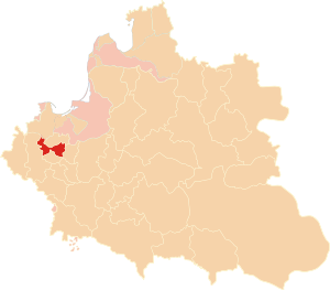
Inowrocław Voivodeship
Distance: Approx. 452 meters
Latitude and longitude: 52.795537,18.260144
Inowrocław Voivodeship (Polish: województwo inowrocławskie) was a unit of administrative division and local government in Poland from the 14th century to the First Partition of Poland in 1772. Together with the neighbouring Brześć Kujawski Voivodeship it was part of the Kuyavia region and the Greater Poland Province. With size of some 2,900 km2 (together with Dobrzyn Land, its area was 5,877 km2.), it was one of the smallest voivodeships of the Polish–Lithuanian Commonwealth.

Inowrocław County
County in Kuyavian-Pomeranian Voivodeship, Poland
Distance: Approx. 677 meters
Latitude and longitude: 52.79305556,18.26111111
Inowrocław County (Polish: powiat inowrocławski) is a unit of territorial administration and local government (powiat) in Kuyavian-Pomeranian Voivodeship, north-central Poland. It came into being on January 1, 1999, as a result of the Polish local government reforms passed in 1998. Its administrative seat and largest town is Inowrocław, which lies 36 km (22 mi) south-west of Toruń and 40 km (25 mi) south-east of Bydgoszcz.

Inowrocław Synagogue
Destroyed synagogue in Inowrocław, Poland
Distance: Approx. 1281 meters
Latitude and longitude: 52.795,18.246
The Inowrocław Synagogue was a former Reform Jewish congregation and synagogue, that was located at 64 Solankowa Street, in what is now Skwer Jan-Paweł II, in Inowrocław, in the Kuyavian-Pomeranian Voivodeship of Poland. Designed in the Byzantine Revival style under the supervision of J. Baumgarten, and completed in 1908, the synagogue served as a house of prayer until World War II when it was destroyed by Nazis in 1939.
Gmina Inowrocław
Gmina in Kuyavian-Pomeranian Voivodeship, Poland
Distance: Approx. 677 meters
Latitude and longitude: 52.79305556,18.26111111
Gmina Inowrocław is a rural gmina (administrative district) in Inowrocław County, Kuyavian-Pomeranian Voivodeship, in north-central Poland. Its seat is the town of Inowrocław, although the town is not part of the territory of the gmina. The gmina covers an area of 171.05 square kilometres (66.0 sq mi), and as of 2006 its total population is 11,106.
Jacewo
Village in Kuyavian-Pomeranian Voivodeship, Poland
Distance: Approx. 1314 meters
Latitude and longitude: 52.8,18.28333333
Jacewo [jaˈt͡sɛvɔ] is a village in the administrative district of Gmina Inowrocław, within Inowrocław County, Kuyavian-Pomeranian Voivodeship, in north-central Poland. It lies approximately 2 kilometres (1 mi) north-east of Inowrocław, 35 km (22 mi) south-west of Toruń, and 40 km (25 mi) south-east of Bydgoszcz.
Kłopot, Kuyavian-Pomeranian Voivodeship
Village in Kuyavian-Pomeranian Voivodeship, Poland
Distance: Approx. 2144 meters
Latitude and longitude: 52.81808611,18.26671111
Kłopot [ˈkwɔpɔt] (translation: Trouble) is a village in the administrative district of Gmina Inowrocław, within Inowrocław County, Kuyavian-Pomeranian Voivodeship, in north-central Poland.
Kruśliwiec
Village in Kuyavian-Pomeranian Voivodeship, Poland
Distance: Approx. 1856 meters
Latitude and longitude: 52.80555556,18.23861111
Kruśliwiec [kruˈɕlivjɛt͡s] is a village in the administrative district of Gmina Inowrocław, within Inowrocław County, Kuyavian-Pomeranian Voivodeship, in north-central Poland.
Marulewy
Village in Kuyavian-Pomeranian Voivodeship, Poland
Distance: Approx. 3090 meters
Latitude and longitude: 52.78527778,18.30388889
Marulewy [maruˈlɛvɨ] is a village in the administrative district of Gmina Inowrocław, within Inowrocław County, Kuyavian-Pomeranian Voivodeship, in north-central Poland.
Mimowola
Village in Kuyavian-Pomeranian Voivodeship, Poland
Distance: Approx. 3592 meters
Latitude and longitude: 52.79416667,18.21111111
Mimowola [mimɔˈvɔla] is a village in the administrative district of Gmina Inowrocław, within Inowrocław County, Kuyavian-Pomeranian Voivodeship, in north-central Poland. It lies approximately 4 kilometres (2 mi) west of Inowrocław, 39 km (24 mi) south-west of Toruń, and 39 km (24 mi) south of Bydgoszcz.

Inowrocław railway station
Railway station in Inowrocław, Poland
Distance: Approx. 1510 meters
Latitude and longitude: 52.8055,18.2443
Inowrocław railway station is a railway station serving the town of Inowrocław, in the Kuyavian-Pomeranian Voivodeship, Poland. The station opened in 1872 and is located on the Chorzów–Tczew railway and Poznań–Skandawa railway. The train services are operated by PKP and Przewozy Regionalne.
Weather in this IP's area
overcast clouds
-3 Celsius
-10 Celsius
-5 Celsius
-3 Celsius
1014 hPa
87 %
1014 hPa
1002 hPa
10000 meters
5.87 m/s
9.96 m/s
302 degree
94 %

