Country:
 France
Region:
City:
Latitude and Longitude:
Time Zone:
Postal Code:
IP information under different IP Channel
ip-api
Country
Region
City
ASN
Time Zone
ISP
Blacklist
Proxy
Latitude
Longitude
Postal
Route
IPinfo
Country
Region
City
ASN
Time Zone
ISP
Blacklist
Proxy
Latitude
Longitude
Postal
Route
MaxMind
Country
Region
City
ASN
Time Zone
ISP
Blacklist
Proxy
Latitude
Longitude
Postal
Route
Luminati
Country
FRRegion
ara
City
saintpriest
ASN
Time Zone
Europe/Paris
ISP
Societe Francaise Du Radiotelephone - SFR SA
Latitude
Longitude
Postal
db-ip
Country
Region
City
ASN
Time Zone
ISP
Blacklist
Proxy
Latitude
Longitude
Postal
Route
ipdata
Country
Region
City
ASN
Time Zone
ISP
Blacklist
Proxy
Latitude
Longitude
Postal
Route
Popular places and events near this IP address

Bron
Commune in Auvergne-Rhône-Alpes, France
Distance: Approx. 3637 meters
Latitude and longitude: 45.7394,4.9139
Bron (French pronunciation: [bʁɔ̃]) is a commune in the Metropolis of Lyon, Auvergne-Rhône-Alpes region, eastern France.
Vénissieux
Commune in Auvergne-Rhône-Alpes, France
Distance: Approx. 3604 meters
Latitude and longitude: 45.6978,4.8867
Vénissieux (French pronunciation: [venisjø] ; Arpitan: Veniciô or Vènissiœx in the Lyonnais dialect) is a commune in the Metropolis of Lyon in Auvergne-Rhône-Alpes region in eastern France.

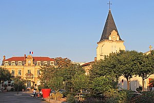
Saint-Priest, Metropolis of Lyon
Commune in Auvergne-Rhône-Alpes, France
Distance: Approx. 1709 meters
Latitude and longitude: 45.6972,4.9447
Saint-Priest (French pronunciation: [sɛ̃ pʁijɛst] ; Arpitan: Sant-Priést) is a commune in the Metropolis of Lyon in the Auvergne-Rhône-Alpes region in east-south France. The 19th-century French historian and epigrapher Auguste Allmer (1815–1899) was a tax collector in Saint-Priest. It is the fourth-largest suburb of the city of Lyon, and is located to its southeast side.

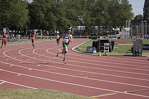
Stade Vuillermet
Sports venue in Lyon
Distance: Approx. 4208 meters
Latitude and longitude: 45.72416667,4.88083333
Stade Vuillermet is a sports stadium in Lyon, Rhône-Alpes in France. The stadium was mostly used for rugby union by Lyon OU, until the club moved to Matmut Stadium in November 2011.

FC Lyon
French sports club
Distance: Approx. 4207 meters
Latitude and longitude: 45.7247,4.8812
Football Club de Lyon is a French sports club. It was established on 17 November 1893, and is notable for its rugby and football sections. They currently compete in the Championnat National 3, the fifth tier of french football.

Lyon tramway
City tramway system in France
Distance: Approx. 1069 meters
Latitude and longitude: 45.71833333,4.92861111
The Lyon tramway (French: Tramway de Lyon) comprises eight lines, seven lines operated by TCL and one by Rhônexpress, in the city of Lyon, France. The original tramway network in Lyon was developed in 1879; the modern network started operation in 2001. Lines T1 and T2 opened in January 2001; T3 opened in December 2006; line T4 opened in April 2009; line Rhônexpress (airport connector) opened in August 2010; line T5 opened in November 2012; line T6 opened in November 2019 and line T7 opened in February 2021.

Vénissieux station
Railway station in the Metropolis of Lyon, France
Distance: Approx. 3307 meters
Latitude and longitude: 45.70527778,4.88805556
Vénissieux station (French: Gare de Vénissieux) is a railway station in the town Vénissieux, a suburb of Lyon, Lyon Metropolis, France. Opened on 1 July 1858, it is served by the SNCF's TER Auvergne-Rhône-Alpes. The station is served by regional trains to Lyon, Bourgoin-Jallieu and Saint-André-le-Gaz.

Saint-Priest station
Distance: Approx. 2480 meters
Latitude and longitude: 45.68666667,4.93388889
Saint-Priest station (French: Gare de Saint-Priest) is a railway station serving the town Saint-Priest, a suburb of Lyon in the Lyon Metropolis, east-south France.
Stade du Rhône
Sports venue in Lyon
Distance: Approx. 2951 meters
Latitude and longitude: 45.71805556,4.89472222
Stade du Rhône is an athletics stadium located in the Parc de Parilly in the commune of Vénissieux in Lyon, France.
Eurexpo
Distance: Approx. 2901 meters
Latitude and longitude: 45.7308,4.9503
Eurexpo is a convention center and exhibition hall in the commune of Chassieu, south-east of Lyon. It is the site of the annual Foire de Lyon.
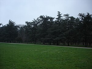
Parc de Parilly
Distance: Approx. 2776 meters
Latitude and longitude: 45.722,4.9
Parc de Parilly is an urban park in the communes of Bron and Vénissieux, Lyon Metropolis. Created in 1937, the park encompasses an area of 178 hectares (440 acres). The park includes numerous sport facilities, including a running track, a hippodrome, and basketball courts.
École de santé des armées
Distance: Approx. 2360 meters
Latitude and longitude: 45.73,4.93
The École de santé des armées (ESA) is the only French military school for future doctors and pharmacists destined to serve within the Ministry of the Armed Forces. They are required to practice in the establishments specific to the health service of the armies, in particular the medical centers of the armies, the hospitals of instruction of the armies, the research centers for the benefit of the Army, the Army of the air force, the National Navy, the National Gendarmerie and military units of Civil Security. It belongs to the Lyon-Bron military health schools (EMSLB) created on September 1, 2018.
Weather in this IP's area
clear sky
20 Celsius
19 Celsius
18 Celsius
21 Celsius
1018 hPa
50 %
1018 hPa
994 hPa
10000 meters
11.32 m/s
350 degree
07:20:11
19:50:05