Country:
 Israel
Region:
City:
Latitude and Longitude:
Time Zone:
Postal Code:
IP information under different IP Channel
ip-api
Country
Region
City
ASN
Time Zone
ISP
Blacklist
Proxy
Latitude
Longitude
Postal
Route
IPinfo
Country
Region
City
ASN
Time Zone
ISP
Blacklist
Proxy
Latitude
Longitude
Postal
Route
MaxMind
Country
Region
City
ASN
Time Zone
ISP
Blacklist
Proxy
Latitude
Longitude
Postal
Route
Luminati
Country
ILRegion
ta
City
telaviv
ASN
Time Zone
Asia/Jerusalem
ISP
Hot-Net internet services Ltd.
Latitude
Longitude
Postal
db-ip
Country
Region
City
ASN
Time Zone
ISP
Blacklist
Proxy
Latitude
Longitude
Postal
Route
ipdata
Country
Region
City
ASN
Time Zone
ISP
Blacklist
Proxy
Latitude
Longitude
Postal
Route
Popular places and events near this IP address
International Jewish Sports Hall of Fame
Sports hall of fame in Netanya, Israel
Distance: Approx. 1443 meters
Latitude and longitude: 32.26093611,34.83539444
The International Jewish Sports Hall of Fame (Hebrew: יד לאיש הספורט היהודי, romanized: Yad Le'ish HaSport HaYehudi) was opened July 7, 1981, in Netanya, Israel. It honors Jewish athletes and their accomplishments from anywhere around the world. It is located at the Wingate Institute for Physical Education and Sport.
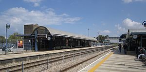
Beit Yehoshua railway station
Railway station in Israel
Distance: Approx. 2300 meters
Latitude and longitude: 32.26283333,34.86026389
Bet Yehoshua railway station (Hebrew: תחנת הרכבת בית יהושע, Taḥanat HaRakevet Beit Yehoshua) is an Israel Railways passenger station located in Beit Yehoshua and serves the village and the southern part of the city of Netanya, with its large industrial zones, as well as other small communities in the area.
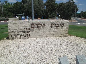
Yakum
Kibbutz in central Israel
Distance: Approx. 197 meters
Latitude and longitude: 32.2475,34.8425
Yakum (Hebrew: יָקוּם, lit. "He (The People) shall rise") is a kibbutz in central Israel. Located in the central part of the Israeli coastal plain, about 30 km north of Tel Aviv, and only 5 km from the southern suburbs of Netanya, it falls under the jurisdiction of Hof HaSharon Regional Council.
Hof HaSharon Regional Council
Israeli regional council
Distance: Approx. 2973 meters
Latitude and longitude: 32.233,34.867
Hof HaSharon Regional Council (Hebrew: מועצה אזורית חוף השרון, Mo'atza Azorit Hof HaSharon, lit. Sharon Coast Regional Council), is a regional council in the Central and Tel Aviv districts of Israel. It is located on the coastline in the Sharon area between Netanya and Herzliya.

Ga'ash
Kibbutz in central Israel
Distance: Approx. 2695 meters
Latitude and longitude: 32.22916667,34.82583333
Ga'ash (Hebrew: גַּעַשׁ, lit. Storm) is a kibbutz in central Israel. Located in the coastal plain to the north of Tel Aviv, it falls under the jurisdiction of Hof HaSharon Regional Council.

Tel Yitzhak
Kibbutz in central Israel
Distance: Approx. 2593 meters
Latitude and longitude: 32.2525,34.86916667
Tel Yitzhak (Hebrew: תֵּל יִצְחָק, lit. 'Yitzhak Hill') is a kibbutz in central Israel. Located in the coastal plain to the south-east of Netanya, it falls under the jurisdiction of Hof HaSharon Regional Council. In 2022 it had a population of 834.

Beit Yehoshua
Moshav in central Israel
Distance: Approx. 2393 meters
Latitude and longitude: 32.26111111,34.86305556
Beit Yehoshua (Hebrew: בֵּית יְהוֹשֻעַ, lit. 'House of Yehoshua') is a moshav in central Israel. Located in the coastal plain near Netanya, it falls under the jurisdiction of Hof HaSharon Regional Council. In 2022 it had a population of 1,117.
Udim
Moshav in central Israel
Distance: Approx. 2112 meters
Latitude and longitude: 32.26638889,34.85138889
Udim (Hebrew: אוּדִים, lit. Firebrands) is a moshav in central Israel. Located near Netanya, it falls under the jurisdiction of Hof HaSharon Regional Council.

Neve Hadassah
Youth village in central Israel
Distance: Approx. 3174 meters
Latitude and longitude: 32.25083333,34.87555556
Neve Hadassah (Hebrew: נְוֵה הֲדַסָּה, lit. 'Hadassah Abode') is a youth village in central Israel. Located in the Sharon plain near Netanya and adjacent to Tel Yitzhak, it falls under the jurisdiction of Hof HaSharon Regional Council. In 2006 it had a population of 668.

Khirbat al-Zababida
Place in Tulkarm, Mandatory Palestine
Distance: Approx. 615 meters
Latitude and longitude: 32.25305556,34.83722222
Khirbat al-Zababida (Arabic: خربة الزبابدة, the Ruin of the People of Kafr Zibad) was a Palestinian Arab village in the Tulkarm Subdistrict. It was depopulated during the 1948 Arab–Israeli War on May 15, 1948. It was located 20 kilometres (12 mi) southwest of Tulkarm, south of Wadi al-Faliq.

Poleg
Stream in Israel
Distance: Approx. 2185 meters
Latitude and longitude: 32.26811944,34.83571667
The Poleg (Hebrew: נחל פולג, romanized: Naḥal Poleg) is a stream in the Sharon plain in Israel that empties into the Mediterranean Sea between Netanya and the Wingate Institute.
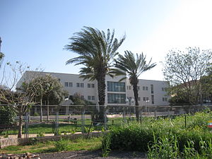
Kiryat Shlomo
Hospital in central Israel
Distance: Approx. 2483 meters
Latitude and longitude: 32.23416667,34.86138889
Kiryat Shlomo (Hebrew: קריית שלמה, lit. Place of Shlomo) is a psychiatric and geriatric hospital in Israel, that has the status of an institutional settlement. It falls within the jurisdiction of Hof HaSharon Regional Council and had a population of 374 in 2022.
Weather in this IP's area
clear sky
28 Celsius
28 Celsius
27 Celsius
28 Celsius
1012 hPa
54 %
1012 hPa
1009 hPa
10000 meters
7.48 m/s
6.44 m/s
357 degree
06:46:26
18:04:43