77.137.193.135 - IP Lookup: Free IP Address Lookup, Postal Code Lookup, IP Location Lookup, IP ASN, Public IP
Country:
 Israel
Region:
City:
Location:
Time Zone:
Postal Code:
ISP:
ASN:
language:
User-Agent:
Proxy IP:
Blacklist:
IP information under different IP Channel
ip-api
Country
Region
City
ASN
Time Zone
ISP
Blacklist
Proxy
Latitude
Longitude
Postal
Route
db-ip
Country
Region
City
ASN
Time Zone
ISP
Blacklist
Proxy
Latitude
Longitude
Postal
Route
IPinfo
Country
Region
City
ASN
Time Zone
ISP
Blacklist
Proxy
Latitude
Longitude
Postal
Route
IP2Location
77.137.193.135Country
ilRegion
hatsafon
City
yoqne'am 'illit
Time Zone
Asia/Jerusalem
ISP
Language
User-Agent
Latitude
Longitude
Postal
ipdata
Country
Region
City
ASN
Time Zone
ISP
Blacklist
Proxy
Latitude
Longitude
Postal
Route
Popular places and events near this IP address
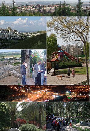
Yokneam Illit
City in northern Israel
Distance: Approx. 848 meters
Latitude and longitude: 32.65944444,35.11
Yokneam Illit (Hebrew: יָקְנְעָם עילית), also Yoqne'am Illit and Jokneam Illit, is a city in northern Israel. It is located in a hilly region of the Lower Galilee at the base of the Carmel Mountains, and overlooks the Jezreel Valley. It is 21 kilometres (13 miles) from Haifa and 80 kilometres (50 mi) from Tel Aviv.

HaZore'a
Kibbutz in northern Israel
Distance: Approx. 1895 meters
Latitude and longitude: 32.64472222,35.12083333
HaZore'a (Hebrew: הַזּוֹרֵעַ, lit. The Sower, named after the neighbouring Tel Zariq, Hebrew: תל זריק) is a kibbutz in northern Israel established in 1936 by German Jews. It is the only kibbutz that was established by members of the Werkleute movement.

Qira, Haifa
Village in Haifa, Mandatory Palestine
Distance: Approx. 998 meters
Latitude and longitude: 32.645,35.1025
Qira (Arabic: قِيرة) was a Palestinian Arab village, located 23 kilometers southeast of Haifa. It was locally referred to as Qira wa Qamun. Its people were Arab tenants, some of whom from the Bedouin tribes of Ka'abiye and Sa'adih.

Eliakim
Place in Northern, Israel
Distance: Approx. 4239 meters
Latitude and longitude: 32.6325,35.06638889
Eliakim (Hebrew: אֶלְיָקִים) is a moshav in northern Israel. Located in the Menashe Heights, it falls under the jurisdiction of Megiddo Regional Council. In 2022 it had a population of 969.

Ein HaEmek
Community settlement in northern Israel
Distance: Approx. 3261 meters
Latitude and longitude: 32.62972222,35.08416667
Ein HaEmek (Hebrew: עֵין הָעֵמֶק, lit. 'Eye of the Valley') is a community settlement in northern Israel. Located near Yokneam, it falls under the jurisdiction of Megiddo Regional Council. In 2022 it had a population of 847.

Yokneam Moshava
Place in Northern, Israel
Distance: Approx. 330 meters
Latitude and longitude: 32.65388889,35.10027778
Yokneam (Hebrew: יָקְנְעָם) is a moshava in the Northern District of Israel. Located on the outskirts of the city of Yokneam Illit on the border of the Jezreel Valley and the Menashe Heights, it falls under the jurisdiction of the Megiddo Regional Council and is administrated by a local committee which is elected every five years. In 2022 it had a population of 1,382.

Khirbat al-Mansura
Arab village in the Haifa subdistrict, Mandatory Palestine
Distance: Approx. 2319 meters
Latitude and longitude: 32.67444444,35.09972222
Khirbat Al-Mansura was a Palestinian village in the Haifa Subdistrict. It was probably depopulated during an offensive by the Carmeli Brigade at the end of April 1948. It was located 18.5 km southeast of Haifa with a mostly Druze population.

Al-Rihaniyya
Arab village in Haifa subdistrict, Mandatory Palestine
Distance: Approx. 4091 meters
Latitude and longitude: 32.62,35.08694444
This page is subject to the extended confirmed restriction related to the Arab-Israeli conflict. Al-Rihaniyya was a Palestinian Arab village in the Haifa Subdistrict. It was depopulated during the 1947–1948 Civil War in Mandatory Palestine on 30 April 1948 as part of the battle of Mishmar HaEmek.

Umm az-Zinat
Place in Haifa, Mandatory Palestine
Distance: Approx. 3669 meters
Latitude and longitude: 32.64805556,35.06527778
Umm az-Zinat (Arabic: أُم الزينات, Umm ez Zînât) was a Palestinian Arab village in the Haifa Subdistrict. It was depopulated during the 1948 War on May 15, 1948, by Golani Brigade's Fourth Battalion. It was located 20.5 km southeast of Haifa.

Ein el-Jarba
Distance: Approx. 2508 meters
Latitude and longitude: 32.6383,35.1231
Ein el-Jarba is a two-period settlement with remains dating to the Early Chalcolithic (6th millennium BC) and the Early Bronze Age IB (4th millennium BC). The Early Chalcolithic settlement is ascribed to the Wadi Rabah culture. The site is located in the Jezreel Valley, ca.

Yokneam–Kfar Yehoshua railway station
Railway station in Israel
Distance: Approx. 3630 meters
Latitude and longitude: 32.6808,35.1257
Yokneam–Kfar Yehoshua railway station (Hebrew: תחנת הרכבת יקנעם – כפר יהושע) is an Israel Railways passenger station situated on the Jezreel Valley railway. The station serves Yokneam Illit, Kiryat Tiv'on, Ramat Yishai and the surrounding area. The station is located between Yokneam and Kfar Yehoshua, east of Highway 70 and south of Highway 722.

Tel Yokneam
Archaeological site in Israel
Distance: Approx. 1159 meters
Latitude and longitude: 32.66416667,35.10175
Tel Yokneam, also spelled Yoqne'am or Jokneam (Hebrew: תֵּל יָקְנְעָם), is an archaeological site located in the northern part of the modern city of Yokneam Illit, Israel. It is known in Arabic as Tell Qamun (Arabic: تل قامون), believed to be a corruption of the Hebrew name. The site is an elevated mound, or tell, spanning around 40 dunams (10 acres/4 ha) and rising steeply to a height of 60 meters (200 ft).
Weather in this IP's area
light rain
12 Celsius
11 Celsius
11 Celsius
12 Celsius
1020 hPa
76 %
1020 hPa
1001 hPa
10000 meters
2.57 m/s
160 degree
20 %