77.119.82.182 - IP Lookup: Free IP Address Lookup, Postal Code Lookup, IP Location Lookup, IP ASN, Public IP
Country:
 Austria
Region:
City:
Location:
Time Zone:
Postal Code:
ISP:
ASN:
language:
User-Agent:
Proxy IP:
Blacklist:
IP information under different IP Channel
ip-api
Country
Region
City
ASN
Time Zone
ISP
Blacklist
Proxy
Latitude
Longitude
Postal
Route
db-ip
Country
Region
City
ASN
Time Zone
ISP
Blacklist
Proxy
Latitude
Longitude
Postal
Route
IPinfo
Country
Region
City
ASN
Time Zone
ISP
Blacklist
Proxy
Latitude
Longitude
Postal
Route
IP2Location
77.119.82.182Country
atRegion
burgenland
City
guttenbach
Time Zone
ISP
Language
User-Agent
Latitude
Longitude
Postal
ipdata
Country
Region
City
ASN
Time Zone
ISP
Blacklist
Proxy
Latitude
Longitude
Postal
Route
Popular places and events near this IP address

Badersdorf
Municipality in Burgenland, Austria
Distance: Approx. 6260 meters
Latitude and longitude: 47.2,16.36666667
Badersdorf (Hungarian: Pöszöny, Croatian: Pesem) is a municipality in Burgenland in the district of Oberwart in Austria.
Großpetersdorf
Municipality in Burgenland, Austria
Distance: Approx. 7524 meters
Latitude and longitude: 47.23333333,16.31666667
Großpetersdorf (Hungarian: Nagyszentmihály) is a municipality in Burgenland in the district of Oberwart in Austria.

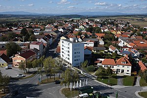
Güssing District
District in Burgenland, Austria
Distance: Approx. 6173 meters
Latitude and longitude: 47.118,16.261
The Bezirk Güssing (Croatian: Kotar Novi Grad; Hungarian: Németújvár Járás) is an administrative district (Bezirk) in the federal state of Burgenland, Austria, bordering on Vas County of Hungary, of which it had been a part prior to 1921. The area of the district is 486.71km², with a population of 25,668 (2022), and the population density is 53 persons per km2. The administrative center and the largest settlement in the district is Güssing.
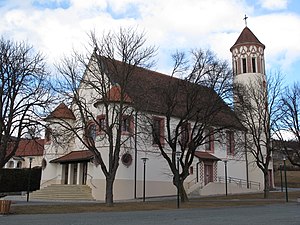
Güttenbach
Municipality in Burgenland, Austria
Distance: Approx. 1261 meters
Latitude and longitude: 47.16666667,16.28333333
Güttenbach (Croatian: Pinkovac, Hungarian: Pinkóc, Slovene: Pinkovec, Pinkovci) is a town in the district of Güssing in the Austrian state of Burgenland.

Neuberg im Burgenland
Municipality in Burgenland, Austria
Distance: Approx. 2523 meters
Latitude and longitude: 47.16666667,16.26666667
Neuberg im Burgenland (Croatian: Nova Gora, Hungarian: Újhegy) is a town in the district of Güssing in the Austrian state of Burgenland.

Rauchwart
Municipality in Burgenland, Austria
Distance: Approx. 6267 meters
Latitude and longitude: 47.13333333,16.23333333
Rauchwart (German pronunciation: [ʁaʊxˈvaʁt] ; Hungarian: Rábort) is a village in the district of Güssing in the Austrian state of Burgenland.

Rohr im Burgenland
Municipality in Burgenland, Austria
Distance: Approx. 6267 meters
Latitude and longitude: 47.13333333,16.23333333
Rohr im Burgenland (Hungarian: Nád or Nádfalu) is a town in the district of Güssing in the Austrian state of Burgenland.

Sankt Michael im Burgenland
Municipality in Burgenland, Austria
Distance: Approx. 6267 meters
Latitude and longitude: 47.13333333,16.23333333
Sankt Michael im Burgenland (Hungarian: Pusztaszentmihály) is a town in the district of Güssing in the Austrian state of Burgenland.

Kohfidisch
Municipality in Burgenland, Austria
Distance: Approx. 3784 meters
Latitude and longitude: 47.16666667,16.35
Kohfidisch (German pronunciation: [koːˈfiːdɪʃ] ; Hungarian: Gyepűfüzes, Croatian: Gornji Fideš, Burgenland Croatian: Zgornji Fideš) is a municipality in the district of Oberwart in the Austrian state of Burgenland.
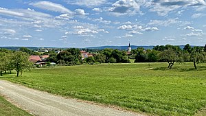
Mischendorf
Municipality in Burgenland, Austria
Distance: Approx. 3916 meters
Latitude and longitude: 47.2,16.31666667
Mischendorf is a town in the district of Oberwart in the Austrian state of Burgenland.

Neuhaus in der Wart
Distance: Approx. 6260 meters
Latitude and longitude: 47.217,16.263
Neuhaus in der Wart (formerly Krobotdorf or Kroatdorf, Croatian: Dobra, Hungarian: Őridobra ) is a Katastralgemeinde of the municipality Mischendorf in southern Burgenland, Austria. It is part of the district Oberwart.

Punitz-Güssing Airfield
Airport in Austria
Distance: Approx. 2535 meters
Latitude and longitude: 47.14694444,16.31666667
Punitz-Güssing Airfield (German: Flugplatz Punitz-Güssing, ICAO: LOGG) is a private use aerodrome located near Punitz, Burgenland, Austria.
Weather in this IP's area
overcast clouds
1 Celsius
1 Celsius
1 Celsius
1 Celsius
1030 hPa
75 %
1030 hPa
994 hPa
10000 meters
0.27 m/s
0.28 m/s
250 degree
99 %