77.118.36.26 - IP Lookup: Free IP Address Lookup, Postal Code Lookup, IP Location Lookup, IP ASN, Public IP
Country:
Region:
City:
Location:
Time Zone:
Postal Code:
IP information under different IP Channel
ip-api
Country
Region
City
ASN
Time Zone
ISP
Blacklist
Proxy
Latitude
Longitude
Postal
Route
Luminati
Country
Region
9
City
vienna
ASN
Time Zone
Europe/Vienna
ISP
Hutchison Drei Austria GmbH
Latitude
Longitude
Postal
IPinfo
Country
Region
City
ASN
Time Zone
ISP
Blacklist
Proxy
Latitude
Longitude
Postal
Route
IP2Location
77.118.36.26Country
Region
niederosterreich
City
rappottenstein
Time Zone
Europe/Vienna
ISP
Language
User-Agent
Latitude
Longitude
Postal
db-ip
Country
Region
City
ASN
Time Zone
ISP
Blacklist
Proxy
Latitude
Longitude
Postal
Route
ipdata
Country
Region
City
ASN
Time Zone
ISP
Blacklist
Proxy
Latitude
Longitude
Postal
Route
Popular places and events near this IP address

Schönbach, Austria
Municipality in Lower Austria, Austria
Distance: Approx. 8662 meters
Latitude and longitude: 48.45,15.03333333
Schönbach is a town in the district of Zwettl in the Austrian state of Lower Austria.
Zwettl District
District in Lower Austria, Austria
Distance: Approx. 8510 meters
Latitude and longitude: 48.581,15.152
Bezirk Zwettl is a district of the state of Lower Austria in Austria.

Waldviertel Pyramid
Distance: Approx. 6150 meters
Latitude and longitude: 48.57555556,15.06138889
The Waldviertel Pyramid is a pyramid in Waldviertel, Austria. It is hidden deep in the forest between Zwettl and Gross-Gerungs. It is the only known structure of its kind in Central Europe.

Großdietmanns
Municipality in Lower Austria, Austria
Distance: Approx. 8037 meters
Latitude and longitude: 48.46666667,15.15
Großdietmanns is a town in the district of Gmünd in the Austrian state of Lower Austria.

Grafenschlag
Municipality in Lower Austria, Austria
Distance: Approx. 6877 meters
Latitude and longitude: 48.5,15.16666667
Grafenschlag is a municipality in the district of Zwettl in the Austrian state of Lower Austria.

Großgöttfritz
Place in Lower Austria, Austria
Distance: Approx. 7780 meters
Latitude and longitude: 48.53333333,15.18333333
Großgöttfritz is a municipality in the district of Zwettl in the Austrian state of Lower Austria.

Rappottenstein
Municipality in Lower Austria, Austria
Distance: Approx. 1081 meters
Latitude and longitude: 48.51666667,15.06666667
Rappottenstein is a municipality in the district of Zwettl in the Austrian state of Lower Austria.
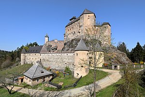
Burg Rappottenstein
Distance: Approx. 1254 meters
Latitude and longitude: 48.51194444,15.08805556
Burg Rappottenstein is a castle in Rappottenstein, Lower Austria, Austria. Burg Rappottenstein is 683 metres (2,241 ft) above sea level.
Weather in this IP's area
scattered clouds
-4 Celsius
-6 Celsius
-5 Celsius
-4 Celsius
1042 hPa
89 %
1042 hPa
945 hPa
10000 meters
1.57 m/s
2.21 m/s
5 degree
38 %
