77.118.34.75 - IP Lookup: Free IP Address Lookup, Postal Code Lookup, IP Location Lookup, IP ASN, Public IP
Country:
Region:
City:
Location:
Time Zone:
Postal Code:
IP information under different IP Channel
ip-api
Country
Region
City
ASN
Time Zone
ISP
Blacklist
Proxy
Latitude
Longitude
Postal
Route
Luminati
Country
Region
9
City
vienna
ASN
Time Zone
Europe/Vienna
ISP
Hutchison Drei Austria GmbH
Latitude
Longitude
Postal
IPinfo
Country
Region
City
ASN
Time Zone
ISP
Blacklist
Proxy
Latitude
Longitude
Postal
Route
IP2Location
77.118.34.75Country
Region
burgenland
City
horitschon
Time Zone
Europe/Vienna
ISP
Language
User-Agent
Latitude
Longitude
Postal
db-ip
Country
Region
City
ASN
Time Zone
ISP
Blacklist
Proxy
Latitude
Longitude
Postal
Route
ipdata
Country
Region
City
ASN
Time Zone
ISP
Blacklist
Proxy
Latitude
Longitude
Postal
Route
Popular places and events near this IP address
Raiding, Austria
Place in Burgenland, Austria
Distance: Approx. 2235 meters
Latitude and longitude: 47.56666667,16.53333333
Raiding (German pronunciation: [ˈʁaɪdɪŋ]; Hungarian: Doborján, pronounced [ˈdoborjaːn]; Croatian: Rajnof) is a small Austrian market town in the district of Oberpullendorf in Burgenland. It is the birthplace of Franz Liszt.
Oberpullendorf District
District in Burgenland, Austria
Distance: Approx. 6825 meters
Latitude and longitude: 47.534,16.496
Bezirk Oberpullendorf (Croatian: Kotar Gornja Pulja; Hungarian: Felsőpulya Járás) is a district of the state of Burgenland in Austria. As of 2023, it had a population of 37,743.

Deutschkreutz
Municipality in Burgenland, Austria
Distance: Approx. 6206 meters
Latitude and longitude: 47.60166667,16.62805556
Deutschkreutz (Hungarian: Sopronkeresztúr until 1899, Németkeresztúr Yiddish: צעלעם, romanized: Zelem Croatian: Kerestur) is an Austrian market town in the district of Oberpullendorf in the state of Burgenland.

Lackenbach
Municipality in Burgenland, Austria
Distance: Approx. 6584 meters
Latitude and longitude: 47.58944444,16.46277778
Lackenbach (Hungarian: Lakompak, Croatian: Lakimpuh) is an Austrian municipality in the District of Oberpullendorf, Burgenland.

Horitschon
Municipality in Burgenland, Austria
Distance: Approx. 4 meters
Latitude and longitude: 47.58333333,16.55
Horitschon (German pronunciation: [ˈhɔʁɪt͡ʃɔn] ; Croatian: Haračun, Hungarian: Haracsony) is a town in the district of Oberpullendorf in the Austrian state of Burgenland. One of five Hungarian consulates at Austria is placed here.

Lackendorf
Municipality in Burgenland, Austria
Distance: Approx. 3754 meters
Latitude and longitude: 47.58333333,16.5
Lackendorf (Croatian: Lakindrof, Hungarian: Lakfalva) is a town in the district of Oberpullendorf in the Austrian state of Burgenland.

Ritzing
Municipality in Burgenland, Austria
Distance: Approx. 5280 meters
Latitude and longitude: 47.61666667,16.5
Ritzing (Croatian: Ricinja, Hungarian: Récény) is a town in the district of Oberpullendorf in the Austrian state of Burgenland.
Unterfrauenhaid
Municipality in Burgenland, Austria
Distance: Approx. 4187 meters
Latitude and longitude: 47.56666667,16.5
Unterfrauenhaid (Croatian: Svetica, Hungarian: Lók) is a town in the district of Oberpullendorf in the Austrian state of Burgenland.

Harka
Place in Győr-Moson-Sopron, Hungary
Distance: Approx. 6716 meters
Latitude and longitude: 47.63333333,16.6
Harka is a village in Győr-Moson-Sopron County, Hungary.
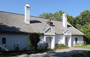
Liszthaus Raiding
Distance: Approx. 2401 meters
Latitude and longitude: 47.56694444,16.52916667
The Liszthaus Raiding is the building where Franz Liszt was born in 1811 which has been a museum since 1979. It is located in Raiding, a town in Burgenland province of Austria. A concert hall next to the house was opened in 2006.

Balf, Hungary
Town in Hungary
Distance: Approx. 6713 meters
Latitude and longitude: 47.6333,16.6
Balf (German: Wolfs) was a village in Sopron then Győr-Sopron County. In 1985 it became part of the town of Sopron. It has approximately 1,000 inhabitants.

Memorial to the Jews of Zelem
Holocaust memorial
Distance: Approx. 5951 meters
Latitude and longitude: 47.599074,16.625736
The Memorial to the Jews of Zelem (German: Denkmal für die Juden von Zelem) commemorates the Jewish community in the Austrian market town of Deutschkreutz in Burgenland, which was expelled in 1938. It was erected and unveiled in 2012 and is located in front of the former residence of the composer Karl Goldmark. The memorial was initiated by Michael Feyer.
Weather in this IP's area
clear sky
3 Celsius
-1 Celsius
2 Celsius
5 Celsius
1038 hPa
48 %
1038 hPa
1008 hPa
10000 meters
3.38 m/s
4.95 m/s
4 degree
5 %

