Country:
Region:
City:
Latitude and Longitude:
Time Zone:
Postal Code:
IP information under different IP Channel
ip-api
Country
Region
City
ASN
Time Zone
ISP
Blacklist
Proxy
Latitude
Longitude
Postal
Route
Luminati
Country
ASN
Time Zone
Europe/Budapest
ISP
Dravanet Co Ltd.
Latitude
Longitude
Postal
IPinfo
Country
Region
City
ASN
Time Zone
ISP
Blacklist
Proxy
Latitude
Longitude
Postal
Route
db-ip
Country
Region
City
ASN
Time Zone
ISP
Blacklist
Proxy
Latitude
Longitude
Postal
Route
ipdata
Country
Region
City
ASN
Time Zone
ISP
Blacklist
Proxy
Latitude
Longitude
Postal
Route
Popular places and events near this IP address
Újlipótváros
Distance: Approx. 645 meters
Latitude and longitude: 47.5186,19.0542
Újlipótváros ("New Leopold Town") is a neighborhood in the 13th district of Budapest, Hungary. It is located north to Lipótváros ("Leopold Town") neighbourhood of the 5th District, with the Szent István Boulevard (Szent István körút) separating it from its southern neighbor, Lipótváros. It lies east of the river Danube, west of Terézváros, and south of Vizafogó.

Budapest Nyugati station
Railway station in Budapest, Hungary
Distance: Approx. 1154 meters
Latitude and longitude: 47.51083333,19.0575
Budapest Nyugati station (Hungarian: Nyugati pályaudvar, pronounced [ˈɲuɡɒti ˈpaːjɒudvɒr]; lit. 'western railway station'), generally referred to simply as Nyugati, is one of the three main railway terminals in Budapest, Hungary. The station is on the Pest side of Budapest, accessible by the 4 and 6 tramline and the M3 metro line.

Lehel tér metro station
Budapest metro station
Distance: Approx. 377 meters
Latitude and longitude: 47.5175,19.06055556
Lehel tér is a station on the Budapest Metro M3 line. It opened on 30 December 1981 with the third phase of the M3 rollout. It was the first phase to run northbound from Deák tér on the line.

Dózsa György út metro station
Budapest metro station
Distance: Approx. 395 meters
Latitude and longitude: 47.52416667,19.06333333
Dózsa György út (Hungarian pronunciation: [ˈdoːʒɒ ˈɟørɟ ˈuːt]) is a station on the Budapest Metro Line 3 (North-South). It is located beneath Váci Avenue at its intersection with the eponymous street Dózsa György út. The station was opened on 7 November 1984 as part of the extension from Lehel tér to Árpád híd.

WestEnd City Center
Shopping mall in Budapest, Hungary
Distance: Approx. 1060 meters
Latitude and longitude: 47.511725,19.05749167
The Westend Shopping Center is a shopping centre built by Hungarian TriGránit Ltd. located next to the Western Railway Station, in Budapest, Hungary. Opened on 12 November 1999, it is known for having been the largest mall in Central Europe until larger ones were inaugurated, including Arena Plaza, also in Pest.

Gundel
Distance: Approx. 1193 meters
Latitude and longitude: 47.51742222,19.07730556
Gundel is a well-known restaurant located in the Budapest City Park, Hungary.

Nyugati pályaudvar metro station
Budapest metro station
Distance: Approx. 1117 meters
Latitude and longitude: 47.51138889,19.05666667
Nyugati pályaudvar (Western Railway Station) is a station on the M3 (North-South) line of the Budapest Metro. It is nominally located on the borders of District V, District VI and District XIII, the station itself is under Váci Road at between its intersections with Grand Boulevard and Katona József Street. The station was opened on 30 December 1981 as part of the extension of the line from Deák Ferenc tér to Lehel tér.

Budapest Zoo and Botanical Garden
Zoo in Budapest, Hungary
Distance: Approx. 1189 meters
Latitude and longitude: 47.51802222,19.07750556
The Budapest Zoo & Botanical Garden (Hungarian: Fővárosi Állat- és Növénykert, lit. 'Metropolitan Zoo and Botanical Garden') is the oldest zoo in Hungary and one of the oldest in the world. It has 1,072 animal species and is located within the City Park of Budapest, in the centre of the city, unusually for a zoo. The zoo opened its doors on 9 August 1866.
Artpool Art Research Center
Distance: Approx. 833 meters
Latitude and longitude: 47.52023672,19.07325697
Artpool Art Research Center is an archive, research space, specialist and media library in Budapest, Hungary, dedicated to international contemporary and avant-garde arts, such as Artist's books, artistamp, mail art, visual poetry, sound poetry, conceptual art, fluxus, installation, performance. It was founded in 1979 based on the "Active Archive" conception as a center for the type of avant-garde art that was marginalized by the state-socialist establishment. The "Active Archive does not only collect material already existing 'out there', but the way it operates also generates the very material to be archived".
Epreskert Art Colony
Distance: Approx. 1130 meters
Latitude and longitude: 47.513,19.072
Epreskert Art Colony (Hungarian: Epreskerti művésztelep; the name means "Mulberry Garden" in Hungarian) was an artists' colony in Budapest in the last decades of the 19th and the first half of the 20th century. Among the artists who worked and lived there the most important were sculptors György Zala and Adolf Huszár, and painter Árpád Feszty.
Oblique (Vasarely)
Collage by 20th-century Hungarian artist
Distance: Approx. 1221 meters
Latitude and longitude: 47.5159,19.0768
Oblique (in Hungarian: Ferde) is a collage by Hungarian artist Victor Vasarely from 1966 to 1974.
Dózsa György Street Synagogue
Former synagogue in Budapest, Hungary
Distance: Approx. 428 meters
Latitude and longitude: 47.52239,19.06732
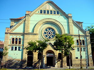
The Dózsa György Street Synagogue (Hungarian: Dózsa György úti zsinagóga), or Angyalföld Synagogue, is a former Orthodox Jewish synagogue located on Dózsa György Street (formerly Aréna Street), in Újlipótváros, in the XIII District of Budapest, in Hungary. Completed as a synagogue in 1909, used as a concentration camp during World War II, and subsequently for profaned use, the building was repurposed in 1984 as an indoor sports center by the Budapest Honvéd Sports Association as a fencing hall. The congregation continues to worship in the cultural hall located on the site; led by Rabbi Peter Deutsch.
Weather in this IP's area
overcast clouds
7 Celsius
7 Celsius
7 Celsius
9 Celsius
1032 hPa
66 %
1032 hPa
1018 hPa
10000 meters
1.11 m/s
1.15 m/s
66 degree
100 %
06:38:31
16:16:34


