77.111.119.229 - IP Lookup: Free IP Address Lookup, Postal Code Lookup, IP Location Lookup, IP ASN, Public IP
Country:
 USA
USARegion:
City:
Location:
Time Zone:
Postal Code:
ISP:
ASN:
language:
User-Agent:
Proxy IP:
Blacklist:
IP information under different IP Channel
ip-api
Country
Region
City
ASN
Time Zone
ISP
Blacklist
Proxy
Latitude
Longitude
Postal
Route
db-ip
Country
Region
City
ASN
Time Zone
ISP
Blacklist
Proxy
Latitude
Longitude
Postal
Route
IPinfo
Country
Region
City
ASN
Time Zone
ISP
Blacklist
Proxy
Latitude
Longitude
Postal
Route
IP2Location
77.111.119.229Country
usRegion
new york
City
new york city
Time Zone
America/New_York
ISP
Language
User-Agent
Latitude
Longitude
Postal
ipdata
Country
Region
City
ASN
Time Zone
ISP
Blacklist
Proxy
Latitude
Longitude
Postal
Route
Popular places and events near this IP address

Upper West Side
Neighborhood in New York City
Distance: Approx. 201 meters
Latitude and longitude: 40.787,-73.975
The Upper West Side (UWS) is a neighborhood in the borough of Manhattan in New York City. It is bounded by Central Park on the east, the Hudson River on the west, West 59th Street to the south, and West 110th Street to the north. The Upper West Side is adjacent to the neighborhoods of Hell's Kitchen to the south, Columbus Circle to the southeast, and Morningside Heights to the north.

Children's Museum of Manhattan
Distance: Approx. 49 meters
Latitude and longitude: 40.78586111,-73.97722222
The Children’s Museum of Manhattan is located on the Upper West Side of Manhattan in New York City. It was founded by Bette Korman, under the name GAME (Growth Through Art and Museum Experience), in 1973. The museum adopted its' current name on May 2, 1985 and moved to its current location on West 83rd Street in 1989.

Zabar's
Specialty food store in New York City
Distance: Approx. 261 meters
Latitude and longitude: 40.78480556,-73.97958333
Zabar's ( ZAY-barz) is an appetizing store at 2245 Broadway and 80th Street, on the Upper West Side of Manhattan in New York City, founded by Louis Zabar and Lillian Zabar. It is known for its selection of bagels, smoked fish, olives, and cheeses. While considered a Jewish delicatessen, Zabar's does not serve kosher food.

86th Street station (IRT Broadway–Seventh Avenue Line)
New York City Subway station in Manhattan
Distance: Approx. 233 meters
Latitude and longitude: 40.7883,-73.9764
The 86th Street station is a local station on the IRT Broadway–Seventh Avenue Line of the New York City Subway. Located at the intersection of West 86th Street and Broadway in the Upper West Side neighborhood of Manhattan, it is served by the 1 train at all times and the 2 train during late nights. The 86th Street station was constructed for the Interborough Rapid Transit Company (IRT) as part of the city's first subway line, which was approved in 1900.
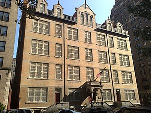
Public School 9 (historic building)
United States historic place
Distance: Approx. 189 meters
Latitude and longitude: 40.78638889,-73.97944444
Public School 9, originally known as Grammar School 9, then later the John Jasper School and currently the Mickey Mantle School, is a historic school building at 466 West End Avenue at West 82nd Street on the Upper West Side of Manhattan, New York City. It was built in 1894-96, and was designed by C. B. J. Snyder, the Superintendent of School Buildings. The building was listed on the U.S. National Register of Historic Places in 1987, and was designated a New York City landmark in 2009.

West Side (Manhattan)
Area of Manhattan in New York City
Distance: Approx. 201 meters
Latitude and longitude: 40.788,-73.978
The West Side of Manhattan refers to the side of Manhattan Island that abuts the Hudson River and faces the U.S. state of New Jersey. The major neighborhoods on the West Side are (from north to south) Inwood, Hudson Heights, Washington Heights, West Harlem, Morningside Heights, Manhattan Valley, the Upper West Side, Hell's Kitchen, Chelsea, the West Village, SoHo, and Tribeca. The 8th Avenue and West Side subway lines connect all parts of the West Side.

Bretton Hall (Manhattan)
Building in New York City, New York
Distance: Approx. 178 meters
Latitude and longitude: 40.78777778,-73.97638889
Bretton Hall is a twelve-story residential building at 2350 Broadway, spanning from West 85th to 86th Street on the Upper West Side of Manhattan, New York City.

Metropolitan Fireproof Warehouse
Structure in New York, US
Distance: Approx. 117 meters
Latitude and longitude: 40.7855,-73.9763
Metropolitan Fireproof Warehouse was an 11-story structure built on the Upper West Side of Manhattan, New York City, in 1925. It fronted seventy-four feet on Amsterdam Avenue between 82nd Avenue and 83rd Street. Continuing in its rear for one hundred feet, the edifice possessed an L fronting twenty-five feet on West 83rd Street.

520 West End Avenue
Distance: Approx. 221 meters
Latitude and longitude: 40.78819444,-73.97797222
520 West End Avenue, also known as the John B. and Isabella Leech Residence, is a landmarked mansion on the northeast corner of West End Avenue and 85th Street, on the Upper West Side of Manhattan. The house, built as a single-family residence, was built in 1892 as the residence of Isabella and John B. Leech. Leech was a prosperous cotton broker.

West-Park Presbyterian Church
Church in Manhattan, New York
Distance: Approx. 266 meters
Latitude and longitude: 40.78777778,-73.97472222
West-Park Presbyterian Church is a Romanesque Revival Presbyterian church located on the corner of Amsterdam Avenue at 86th Street on the Upper West Side of Manhattan in New York City. It consists of a main sanctuary and chapel.

The Belnord
Condominium building in Manhattan, New York
Distance: Approx. 244 meters
Latitude and longitude: 40.78833333,-73.97611111
The Belnord is a condominium building at 225 West 86th Street on the Upper West Side of Manhattan in New York City. The 13-story structure was designed by Hiss and Weekes in the Italian Renaissance Revival style and occupies the full block between Broadway, Amsterdam Avenue, and 86th and 87th Streets. It was built between 1908 and 1909 by a syndicate of investors as a rental apartment building.

Holy Trinity Church (Manhattan)
Catholic church in Manhattan, New York
Distance: Approx. 91 meters
Latitude and longitude: 40.785505,-73.977447
The Church of the Holy Trinity is a Roman Catholic parish church in the Roman Catholic Archdiocese of New York, located at 213 West 82nd Street near Amsterdam Avenue in the Upper West Side neighborhood of Manhattan, New York City. The parish was established in 1898.
Weather in this IP's area
clear sky
-3 Celsius
-6 Celsius
-6 Celsius
-1 Celsius
1030 hPa
59 %
1030 hPa
1028 hPa
10000 meters
1.79 m/s
3.13 m/s
49 degree